Photos • Location
You can help expand this article with text translated from
the corresponding article in Japanese. (October 2011) Click [show] for important translation instructions.
|
| Mimurogawa Dam | |
|---|---|
 | |
| Location | Okayama Prefecture, Japan |
| Coordinates | 35°02′02″N 133°20′24″E / 35.03389°N 133.34000°E |
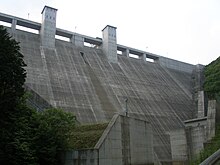
Mimurogawa Dam ( Japanese: 三室川ダム) is a dam in the Okayama Prefecture, Japan, completed in 2005. [1]
References
You can help expand this article with text translated from
the corresponding article in Japanese. (October 2011) Click [show] for important translation instructions.
|
| Mimurogawa Dam | |
|---|---|
 | |
| Location | Okayama Prefecture, Japan |
| Coordinates | 35°02′02″N 133°20′24″E / 35.03389°N 133.34000°E |
Mimurogawa Dam ( Japanese: 三室川ダム) is a dam in the Okayama Prefecture, Japan, completed in 2005. [1]
References