Mehriz
Persian: مهريز | |
|---|---|
City | |
 Pahlavanpoor Garden, Mehriz | |
 Mehriz | |
| Coordinates: 31°34′39″N 54°26′13″E / 31.57750°N 54.43694°E [1] | |
| Country | Iran |
| Province | Yazd |
| County | Mehriz |
| District | Central |
| Population (2016)
[2] | |
| • Total | 34,237 |
| Time zone | UTC+3:30 ( IRST) |
Mehriz ( Persian: مهريز) [a] is a city in the Central District of Mehriz County, Yazd province, Iran, serving as capital of both the county and the district. [4] It shares borders with Yazd to the north, Anar to the southeast, Shahre Babak in Kerman Province to the south, Marvast to the southwest, Taft to the west, and Bafq to the east. Additionally, it lies along the transit highway connecting Bandar Abbas to Tehran, and it marks the beginning of the highway under construction from Mehriz to Neyriz.
Mehriz, formerly known as Mehrgard, later changed to Mehrjerd and Mehriz, owes its name to the directive of Mehrnegar, the daughter of Anushiravan (Khosrow I), a Sassanian king. Situated in the central part of the Yazd province in Iran, Mehriz is renowned for its historical and cultural significance. Let’s explore some of its fascinating attractions:
- Zeen al-Din Caravanserai: A historic caravanserai that served as a resting place for travelers along the ancient trade routes.
- Mehrpadin Complex: This includes a castle (known as Mehrpadin Castle), which dates back to ancient times.
- Zoroastrian Pirnakki Shrine: A sacred site associated with Zoroastrianism.
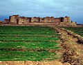
- Sariz Castle: An ancient fortress with a rich history.
- Pahlavanpour Mansion: An elegant historical building.
- Tallest Wind Tower (Badgir): Mehriz boasts the tallest wind tower in Iran.
- Round Caravanserai: The only circular caravanserai in the country. [5]
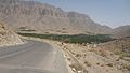
In addition to these, Mehriz has over 600 historical and cultural remnants, with 89 of them registered as national heritage sites in Iran. The city’s heritage dates back more than 10,000 years, as evidenced by the rock carvings on Mount Arnan.
At the time of the 2006 National Census, the city's population was 26,364 in 6,954 households. [6] The following census in 2011 counted 28,483 people in 8,149 households. [7] The 2016 census measured the population of the city as 34,237 people in 10,344 households. [2]
-

-
 Zein Aldin Castle
 -
 Pir-e-Naraki Sanctuary
 -
 Khoshnevis Garden
 -
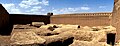
 Sar Yazd Castle
 -
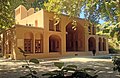 Pahlavanpour Garden
 -
 Khormiz Castle
 -
 Mongabad cypress
 -
 S̄ānīābād
 -
 Khvormiz
 -
 Gharbalbiz spring
 -
 Gharbalbiz spring
 -
 Saryazd Castle
 -
 Caravanserai in Mehriz,
 -
 SarYazd Castle
 -
 Mount Ernan
 -
 manshad
 -
 Tezenj Vellage


.jpg)
.jpg)

.jpg)


- ^ OpenStreetMap contributors (2 March 2023). "Mehriz, Mehriz County" (Map). OpenStreetMap (in Persian). Retrieved 2 March 2023.
- ^ a b "Census of the Islamic Republic of Iran, 1395 (2016)". AMAR (in Persian). The Statistical Center of Iran. p. 21. Archived from the original (Excel) on 18 November 2020. Retrieved 19 December 2022.
- ^ Mehriz can be found at GEOnet Names Server, at this link, by opening the Advanced Search box, entering "-3074688" in the "Unique Feature Id" form, and clicking on "Search Database".
- ^ "The head of Mehriz Islamic Revolution Housing Foundation said: In 2016, 40 residential units were built in this city and given to qualified urban and rural applicants". Yazdi News (in Persian). Archived from the original on 4 December 2020. Retrieved 19 December 2023.
- ^ "مهریز", ویکیپدیا، دانشنامهٔ آزاد (in Persian), 7 July 2024, retrieved 7 July 2024
- ^ "Census of the Islamic Republic of Iran, 1385 (2006)". AMAR (in Persian). The Statistical Center of Iran. p. 21. Archived from the original (Excel) on 20 September 2011. Retrieved 25 September 2022.
- ^ "Census of the Islamic Republic of Iran, 1390 (2011)". Syracuse University (in Persian). The Statistical Center of Iran. p. 21. Archived from the original (Excel) on 20 January 2023. Retrieved 19 December 2022.
Yazd Province, Iran | |||||||||||||||||||||
|---|---|---|---|---|---|---|---|---|---|---|---|---|---|---|---|---|---|---|---|---|---|
| Capital |  | ||||||||||||||||||||
| Counties and cities |
| ||||||||||||||||||||
| Landmarks |
| ||||||||||||||||||||
| populated places | |||||||||||||||||||||
| Capital | |||||||||||||||||
|---|---|---|---|---|---|---|---|---|---|---|---|---|---|---|---|---|---|
| Districts |
| ||||||||||||||||
|
| This Mehriz County location article is a stub. You can help Wikipedia by expanding it. |
Mehriz
Persian: مهريز | |
|---|---|
City | |
|
Pahlavanpoor Garden, Mehriz | |
Mehriz | |
| Coordinates: 31°34′39″N 54°26′13″E / 31.57750°N 54.43694°E [1] | |
| Country | Iran |
| Province | Yazd |
| County | Mehriz |
| District | Central |
| Population (2016)
[2] | |
| • Total | 34,237 |
| Time zone | UTC+3:30 ( IRST) |
Mehriz ( Persian: مهريز) [a] is a city in the Central District of Mehriz County, Yazd province, Iran, serving as capital of both the county and the district. [4] It shares borders with Yazd to the north, Anar to the southeast, Shahre Babak in Kerman Province to the south, Marvast to the southwest, Taft to the west, and Bafq to the east. Additionally, it lies along the transit highway connecting Bandar Abbas to Tehran, and it marks the beginning of the highway under construction from Mehriz to Neyriz.
Mehriz, formerly known as Mehrgard, later changed to Mehrjerd and Mehriz, owes its name to the directive of Mehrnegar, the daughter of Anushiravan (Khosrow I), a Sassanian king. Situated in the central part of the Yazd province in Iran, Mehriz is renowned for its historical and cultural significance. Let’s explore some of its fascinating attractions:
- Zeen al-Din Caravanserai: A historic caravanserai that served as a resting place for travelers along the ancient trade routes.
- Mehrpadin Complex: This includes a castle (known as Mehrpadin Castle), which dates back to ancient times.
- Zoroastrian Pirnakki Shrine: A sacred site associated with Zoroastrianism.
- Sariz Castle: An ancient fortress with a rich history.
- Pahlavanpour Mansion: An elegant historical building.
- Tallest Wind Tower (Badgir): Mehriz boasts the tallest wind tower in Iran.
- Round Caravanserai: The only circular caravanserai in the country. [5]
In addition to these, Mehriz has over 600 historical and cultural remnants, with 89 of them registered as national heritage sites in Iran. The city’s heritage dates back more than 10,000 years, as evidenced by the rock carvings on Mount Arnan.
At the time of the 2006 National Census, the city's population was 26,364 in 6,954 households. [6] The following census in 2011 counted 28,483 people in 8,149 households. [7] The 2016 census measured the population of the city as 34,237 people in 10,344 households. [2]
-
-
Zein Aldin Castle
-
Pir-e-Naraki Sanctuary
-
Khoshnevis Garden
-
Sar Yazd Castle
-
Pahlavanpour Garden
-
Khormiz Castle
-
Mongabad cypress
-
S̄ānīābād
-
Khvormiz
-
Gharbalbiz spring
-
Gharbalbiz spring
-
Saryazd Castle
-
Caravanserai in Mehriz,
-
SarYazd Castle
-
Mount Ernan
-
manshad
-
Tezenj Vellage
- ^ OpenStreetMap contributors (2 March 2023). "Mehriz, Mehriz County" (Map). OpenStreetMap (in Persian). Retrieved 2 March 2023.
- ^ a b "Census of the Islamic Republic of Iran, 1395 (2016)". AMAR (in Persian). The Statistical Center of Iran. p. 21. Archived from the original (Excel) on 18 November 2020. Retrieved 19 December 2022.
- ^ Mehriz can be found at GEOnet Names Server, at this link, by opening the Advanced Search box, entering "-3074688" in the "Unique Feature Id" form, and clicking on "Search Database".
- ^ "The head of Mehriz Islamic Revolution Housing Foundation said: In 2016, 40 residential units were built in this city and given to qualified urban and rural applicants". Yazdi News (in Persian). Archived from the original on 4 December 2020. Retrieved 19 December 2023.
- ^ "مهریز", ویکیپدیا، دانشنامهٔ آزاد (in Persian), 7 July 2024, retrieved 7 July 2024
- ^ "Census of the Islamic Republic of Iran, 1385 (2006)". AMAR (in Persian). The Statistical Center of Iran. p. 21. Archived from the original (Excel) on 20 September 2011. Retrieved 25 September 2022.
- ^ "Census of the Islamic Republic of Iran, 1390 (2011)". Syracuse University (in Persian). The Statistical Center of Iran. p. 21. Archived from the original (Excel) on 20 January 2023. Retrieved 19 December 2022.
Yazd Province, Iran | |||||||||||||||||||||
|---|---|---|---|---|---|---|---|---|---|---|---|---|---|---|---|---|---|---|---|---|---|
| Capital | | ||||||||||||||||||||
| Counties and cities |
| ||||||||||||||||||||
| Landmarks |
| ||||||||||||||||||||
| populated places | |||||||||||||||||||||
| Capital | |||||||||||||||||
|---|---|---|---|---|---|---|---|---|---|---|---|---|---|---|---|---|---|
| Districts |
| ||||||||||||||||
|
| This Mehriz County location article is a stub. You can help Wikipedia by expanding it. |