| UNESCO World Heritage Site | |
|---|---|
 | |
| Location | |
| Criteria | Cultural: ii, iv, v |
| Reference | 493 |
| Inscription | 1988 (12th Session) |
| Area | 65.85 ha |
| Coordinates | 36°26′N 28°13′E / 36.433°N 28.217°E |
The Medieval City of Rhodes was constructed around 1309 to 1523 and is part of the modern capital city of Rhodes on the Island of Rhodes in Greece. The site was added to the UNESCO World Heritage list in 1988. [1]
The Medieval city consists of the high town to the north and the lower town south-southwest. The high town was entirely built by the Hospitaller Rhodes. [2] The Medieval city is located within a 4 kms long wall. [3]
Gallery
-

-
 Medieval church of the Virgin
 -
 Fort Saint Nicolas
 -
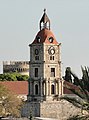 clocktower


References
External links
![]() Media related to
Medieval city of Rhodes at Wikimedia Commons
Media related to
Medieval city of Rhodes at Wikimedia Commons
- Medieval City of Rhodes UNESCO Collection on Google Arts and Culture
- UNESCO entry
.jpg)


|
| This article about Greek history is a stub. You can help Wikipedia by expanding it. |
| UNESCO World Heritage Site | |
|---|---|
|
| |
| Location | |
| Criteria | Cultural: ii, iv, v |
| Reference | 493 |
| Inscription | 1988 (12th Session) |
| Area | 65.85 ha |
| Coordinates | 36°26′N 28°13′E / 36.433°N 28.217°E |
The Medieval City of Rhodes was constructed around 1309 to 1523 and is part of the modern capital city of Rhodes on the Island of Rhodes in Greece. The site was added to the UNESCO World Heritage list in 1988. [1]
The Medieval city consists of the high town to the north and the lower town south-southwest. The high town was entirely built by the Hospitaller Rhodes. [2] The Medieval city is located within a 4 kms long wall. [3]
Gallery
-
-
Medieval church of the Virgin
-
Fort Saint Nicolas
-
clocktower
References
External links
![]() Media related to
Medieval city of Rhodes at Wikimedia Commons
Media related to
Medieval city of Rhodes at Wikimedia Commons
- Medieval City of Rhodes UNESCO Collection on Google Arts and Culture
- UNESCO entry
|
| This article about Greek history is a stub. You can help Wikipedia by expanding it. |