| McKenzie Mountain | |
|---|---|
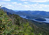
 McKenzie Mountain from
Lake Flower,
Saranac Lake, NY | |
| Highest point | |
| Elevation | 3,861 ft (1,177 m) |
| Prominence | 617 ft (188 m) |
| Coordinates | 44°20′10″N 74°01′53″W / 44.33611°N 74.03139°W |
| Geography | |
| Location | North Elba, New York, U.S. |
| Parent range | Adirondacks |
| Topo map | Saranac Lake |
McKenzie Mountain is a 3,861-foot (1,177 m) mountain in western Essex County in the towns of St. Armand and North Elba in the Adirondack Park, a unit of the Forest Preserve. [1]
History
The mountain was formerly known as Saddleback, due to its shape. There are two trails to the top. One, maintained by NYSDEC, begins at the Jackrabbit Ski Trail, that runs between Saranac Lake and Lake Placid. The other, maintained by the Lake Placid Shore Owner's Association, dates to 1896; it leads from the Lake Shore Path to the summit. [2] Views from the top are extensive, from Whiteface Mountain to the north, with Lake Placid at its feet, to Gothics, Mount Marcy and the Great Range, and the Seward Mountains to the south. A ledge to the west of the trail offers views of the village of Saranac Lake and the Saranac Lakes spread out beyond, Moose Pond, Azure Mountain, Saint Regis Mountain and Debar Mountain to the north.
Climate
| Climate data for McKenzie Mountain 44.3358 N, 74.0347 W, Elevation: 3,514 ft (1,071 m) (1991–2020 normals) | |||||||||||||
|---|---|---|---|---|---|---|---|---|---|---|---|---|---|
| Month | Jan | Feb | Mar | Apr | May | Jun | Jul | Aug | Sep | Oct | Nov | Dec | Year |
| Mean daily maximum °F (°C) | 21.6 (−5.8) |
23.9 (−4.5) |
31.5 (−0.3) |
45.6 (7.6) |
58.5 (14.7) |
66.9 (19.4) |
70.9 (21.6) |
69.6 (20.9) |
63.7 (17.6) |
50.8 (10.4) |
37.0 (2.8) |
27.1 (−2.7) |
47.3 (8.5) |
| Daily mean °F (°C) | 12.8 (−10.7) |
14.5 (−9.7) |
22.4 (−5.3) |
35.6 (2.0) |
48.1 (8.9) |
57.0 (13.9) |
61.3 (16.3) |
60.0 (15.6) |
53.7 (12.1) |
41.9 (5.5) |
29.6 (−1.3) |
19.5 (−6.9) |
38.0 (3.4) |
| Mean daily minimum °F (°C) | 4.0 (−15.6) |
5.1 (−14.9) |
13.3 (−10.4) |
25.5 (−3.6) |
37.8 (3.2) |
47.1 (8.4) |
51.8 (11.0) |
50.3 (10.2) |
43.8 (6.6) |
33.0 (0.6) |
22.2 (−5.4) |
12.0 (−11.1) |
28.8 (−1.7) |
| Average precipitation inches (mm) | 3.75 (95) |
2.79 (71) |
3.48 (88) |
4.44 (113) |
4.78 (121) |
5.85 (149) |
5.31 (135) |
4.93 (125) |
4.68 (119) |
5.31 (135) |
4.24 (108) |
4.06 (103) |
53.62 (1,362) |
| Source: PRISM Climate Group [3] | |||||||||||||
Gallery
-
 Lake Flower, Lower Saranac Lake and Boot Bay Mountain from McKenzie
 -

-
 Whiteface Mountain, left, and Lake Placid, right, from McKenzie


References
- ^ Goodwin, Tony, ed., Adirondack Trails, High Peaks Region, Lake George, New York: Adirondack Mountain Club, 2004. ISBN 1-931951-05-5
- ^ McMartin, Barbara & Bill Ingersoll, Discover the Northern Adirondacks, Lake View Press, Canada Lake, NY, third edition, 2005. ISBN 1-888374-26-8
-
^
"PRISM Climate Group, Oregon State University". PRISM Climate Group, Oregon State University. Retrieved October 20, 2023.
To find the table data on the PRISM website, start by clicking Coordinates (under Location); copy Latitude and Longitude figures from top of table; click Zoom to location; click Precipitation, Minimum temp, Mean temp, Maximum temp; click 30-year normals, 1991-2020; click 800m; click Retrieve Time Series button.
External links
|
| This article about a location in Essex County, New York is a stub. You can help Wikipedia by expanding it. |
| McKenzie Mountain | |
|---|---|
|
McKenzie Mountain from
Lake Flower,
Saranac Lake, NY | |
| Highest point | |
| Elevation | 3,861 ft (1,177 m) |
| Prominence | 617 ft (188 m) |
| Coordinates | 44°20′10″N 74°01′53″W / 44.33611°N 74.03139°W |
| Geography | |
| Location | North Elba, New York, U.S. |
| Parent range | Adirondacks |
| Topo map | Saranac Lake |
McKenzie Mountain is a 3,861-foot (1,177 m) mountain in western Essex County in the towns of St. Armand and North Elba in the Adirondack Park, a unit of the Forest Preserve. [1]
History
The mountain was formerly known as Saddleback, due to its shape. There are two trails to the top. One, maintained by NYSDEC, begins at the Jackrabbit Ski Trail, that runs between Saranac Lake and Lake Placid. The other, maintained by the Lake Placid Shore Owner's Association, dates to 1896; it leads from the Lake Shore Path to the summit. [2] Views from the top are extensive, from Whiteface Mountain to the north, with Lake Placid at its feet, to Gothics, Mount Marcy and the Great Range, and the Seward Mountains to the south. A ledge to the west of the trail offers views of the village of Saranac Lake and the Saranac Lakes spread out beyond, Moose Pond, Azure Mountain, Saint Regis Mountain and Debar Mountain to the north.
Climate
| Climate data for McKenzie Mountain 44.3358 N, 74.0347 W, Elevation: 3,514 ft (1,071 m) (1991–2020 normals) | |||||||||||||
|---|---|---|---|---|---|---|---|---|---|---|---|---|---|
| Month | Jan | Feb | Mar | Apr | May | Jun | Jul | Aug | Sep | Oct | Nov | Dec | Year |
| Mean daily maximum °F (°C) | 21.6 (−5.8) |
23.9 (−4.5) |
31.5 (−0.3) |
45.6 (7.6) |
58.5 (14.7) |
66.9 (19.4) |
70.9 (21.6) |
69.6 (20.9) |
63.7 (17.6) |
50.8 (10.4) |
37.0 (2.8) |
27.1 (−2.7) |
47.3 (8.5) |
| Daily mean °F (°C) | 12.8 (−10.7) |
14.5 (−9.7) |
22.4 (−5.3) |
35.6 (2.0) |
48.1 (8.9) |
57.0 (13.9) |
61.3 (16.3) |
60.0 (15.6) |
53.7 (12.1) |
41.9 (5.5) |
29.6 (−1.3) |
19.5 (−6.9) |
38.0 (3.4) |
| Mean daily minimum °F (°C) | 4.0 (−15.6) |
5.1 (−14.9) |
13.3 (−10.4) |
25.5 (−3.6) |
37.8 (3.2) |
47.1 (8.4) |
51.8 (11.0) |
50.3 (10.2) |
43.8 (6.6) |
33.0 (0.6) |
22.2 (−5.4) |
12.0 (−11.1) |
28.8 (−1.7) |
| Average precipitation inches (mm) | 3.75 (95) |
2.79 (71) |
3.48 (88) |
4.44 (113) |
4.78 (121) |
5.85 (149) |
5.31 (135) |
4.93 (125) |
4.68 (119) |
5.31 (135) |
4.24 (108) |
4.06 (103) |
53.62 (1,362) |
| Source: PRISM Climate Group [3] | |||||||||||||
Gallery
-
Lake Flower, Lower Saranac Lake and Boot Bay Mountain from McKenzie
-
-
Whiteface Mountain, left, and Lake Placid, right, from McKenzie
References
- ^ Goodwin, Tony, ed., Adirondack Trails, High Peaks Region, Lake George, New York: Adirondack Mountain Club, 2004. ISBN 1-931951-05-5
- ^ McMartin, Barbara & Bill Ingersoll, Discover the Northern Adirondacks, Lake View Press, Canada Lake, NY, third edition, 2005. ISBN 1-888374-26-8
-
^
"PRISM Climate Group, Oregon State University". PRISM Climate Group, Oregon State University. Retrieved October 20, 2023.
To find the table data on the PRISM website, start by clicking Coordinates (under Location); copy Latitude and Longitude figures from top of table; click Zoom to location; click Precipitation, Minimum temp, Mean temp, Maximum temp; click 30-year normals, 1991-2020; click 800m; click Retrieve Time Series button.
External links
|
| This article about a location in Essex County, New York is a stub. You can help Wikipedia by expanding it. |