Mayoko | |
|---|---|
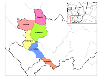
 Mayoko District in the region | |
| Country |
|
| Department | Niari Department |
| Time zone | UTC+1 (GMT +1) |
Mayoko District is a district in the Niari Department of south-western Republic of the Congo. [1] The capital lies at Mayoko. It has a northern border with Gabon. As of 2007, the population is 5,147. [2]
Transport
Mayoko is served by a branch railway of the Congo–Ocean Railway that terminates in Mbinda. It lies near the border with Gabon.
Mining
Mayoko is near deposits of iron ore, which are very close to an existing railway line leading to a port.
See also
References
- ^ "Annuaire Statistique du Congo 2009" (PDF) (in French). Centre National de la Statistique et des Études Économiques (CNSEE). 2011. p. 6. Retrieved 3 June 2012.
- ^ "Population des Départements" (PDF) (in French). Centre National de la Statistique et des Études Économiques (CNSEE). 2011. Retrieved 3 June 2012.
02°19′30″S 12°47′51″E / 2.32500°S 12.79750°E
Mayoko | |
|---|---|
 Mayoko District in the region | |
| Country |
|
| Department | Niari Department |
| Time zone | UTC+1 (GMT +1) |
Mayoko District is a district in the Niari Department of south-western Republic of the Congo. [1] The capital lies at Mayoko. It has a northern border with Gabon. As of 2007, the population is 5,147. [2]
Transport
Mayoko is served by a branch railway of the Congo–Ocean Railway that terminates in Mbinda. It lies near the border with Gabon.
Mining
Mayoko is near deposits of iron ore, which are very close to an existing railway line leading to a port.
See also
References
- ^ "Annuaire Statistique du Congo 2009" (PDF) (in French). Centre National de la Statistique et des Études Économiques (CNSEE). 2011. p. 6. Retrieved 3 June 2012.
- ^ "Population des Départements" (PDF) (in French). Centre National de la Statistique et des Études Économiques (CNSEE). 2011. Retrieved 3 June 2012.
02°19′30″S 12°47′51″E / 2.32500°S 12.79750°E
