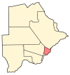
Photos • Location
Matebeleng | |
|---|---|
| Coordinates: 24°32′31″S 26°2′23″E / 24.54194°S 26.03972°E | |
| Country |
|
| District | Kgatleng District |
| Population (2001) | |
| • Total | 1,180 |
Matebeleng, also known as Matebele( Ndebele) is a village in Kgatleng District of Botswana. It is located around 20 km north-east of Gaborone and the population was 1,180 in 2001 census. [1]
References
- ^ "Distribution of population by sex by villages and their associated localities: 2001 population and housing census". Archived from the original on 24 November 2007. Retrieved 8 February 2008.
24°32′31″S 26°2′23″E / 24.54194°S 26.03972°E

