Marienwerder | |
|---|---|
Location of Marienwerder within Barnim district 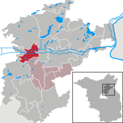 | |
 Marienwerder  Marienwerder | |
| Coordinates: 52°50′33″N 13°36′00″E / 52.84250°N 13.60000°E | |
| Country | Germany |
| State | Brandenburg |
| District | Barnim |
| Municipal assoc. | Biesenthal-Barnim |
| Subdivisions | 3 Ortsteile |
| Government | |
| • Mayor (2019–24) | Annett Klingsporn [1] |
| Area | |
| • Total | 39.92 km2 (15.41 sq mi) |
| Elevation | 35 m (115 ft) |
| Population (2022-12-31)
[2] | |
| • Total | 1,726 |
| • Density | 43/km2 (110/sq mi) |
| Time zone | UTC+01:00 ( CET) |
| • Summer ( DST) | UTC+02:00 ( CEST) |
| Postal codes | 16348 |
| Dialling codes | 03335 |
| Vehicle registration | BAR |
| Website | marienwerder-barnim.de |
Marienwerder is a municipality in the district of Barnim in the state of Brandenburg, Germany.

Every summer since 2004, a two-day music festival called Inselleuchten takes place in Marienwerder in mid-July. From 2007 on the popular actor and musician Axel Prahl hosted it as presenter and figurehead. In 2016 Suzanne Vega gave a stage show here. Due to the COVID-19 pandemic the 2020 festival was canceled and rescheduled to 2021. [3]
History
From 1815 to 1947, Marienwerder was part of the Prussian Province of Brandenburg, from 1947 to 1952 of the State of Brandenburg, from 1952 to 1990 of the East German Bezirk Frankfurt and since 1990 again of Brandenburg.
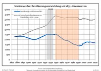
Demography
|
|
|
External links
References
- ^ Landkreis Barnim Wahl der Bürgermeisterin / des Bürgermeisters, accessed 30 June 2021.
- ^ "Bevölkerungsentwicklung und Bevölkerungsstandim Land Brandenburg Dezember 2022" (PDF). Amt für Statistik Berlin-Brandenburg (in German). June 2023.
- ^ "Verlegung auf: 9.–11. Juli 2021". inselleuchten.de/. 2020-05-11. Retrieved 2020-05-14.
- ^ Detailed data sources are to be found in the Wikimedia Commons. Population Projection Brandenburg at Wikimedia Commons
Towns and municipalities in
Barnim district | ||
|---|---|---|
 | ||
| International | |
|---|---|
| National | |
| Geographic | |
|
| This Brandenburg location article is a stub. You can help Wikipedia by expanding it. |
Marienwerder | |
|---|---|
Location of Marienwerder within Barnim district | |
Marienwerder Marienwerder | |
| Coordinates: 52°50′33″N 13°36′00″E / 52.84250°N 13.60000°E | |
| Country | Germany |
| State | Brandenburg |
| District | Barnim |
| Municipal assoc. | Biesenthal-Barnim |
| Subdivisions | 3 Ortsteile |
| Government | |
| • Mayor (2019–24) | Annett Klingsporn [1] |
| Area | |
| • Total | 39.92 km2 (15.41 sq mi) |
| Elevation | 35 m (115 ft) |
| Population (2022-12-31)
[2] | |
| • Total | 1,726 |
| • Density | 43/km2 (110/sq mi) |
| Time zone | UTC+01:00 ( CET) |
| • Summer ( DST) | UTC+02:00 ( CEST) |
| Postal codes | 16348 |
| Dialling codes | 03335 |
| Vehicle registration | BAR |
| Website | marienwerder-barnim.de |
Marienwerder is a municipality in the district of Barnim in the state of Brandenburg, Germany.
Every summer since 2004, a two-day music festival called Inselleuchten takes place in Marienwerder in mid-July. From 2007 on the popular actor and musician Axel Prahl hosted it as presenter and figurehead. In 2016 Suzanne Vega gave a stage show here. Due to the COVID-19 pandemic the 2020 festival was canceled and rescheduled to 2021. [3]
History
From 1815 to 1947, Marienwerder was part of the Prussian Province of Brandenburg, from 1947 to 1952 of the State of Brandenburg, from 1952 to 1990 of the East German Bezirk Frankfurt and since 1990 again of Brandenburg.
Demography
|
|
|
External links
References
- ^ Landkreis Barnim Wahl der Bürgermeisterin / des Bürgermeisters, accessed 30 June 2021.
- ^ "Bevölkerungsentwicklung und Bevölkerungsstandim Land Brandenburg Dezember 2022" (PDF). Amt für Statistik Berlin-Brandenburg (in German). June 2023.
- ^ "Verlegung auf: 9.–11. Juli 2021". inselleuchten.de/. 2020-05-11. Retrieved 2020-05-14.
- ^ Detailed data sources are to be found in the Wikimedia Commons. Population Projection Brandenburg at Wikimedia Commons
Towns and municipalities in
Barnim district | ||
|---|---|---|
| ||
| International | |
|---|---|
| National | |
| Geographic | |
|
| This Brandenburg location article is a stub. You can help Wikipedia by expanding it. |