Mandiana | |
|---|---|
Sub-prefecture and town | |
 | |
| Coordinates: 10°38′N 8°41′W / 10.633°N 8.683°W | |
| Country | |
| Region | Kankan Region |
| Prefecture | Mandiana Prefecture |
| Government | |
| • Mayor | Ibrahima Sira Diakité |
| Population (2014) | |
| • Total | 25,791 |
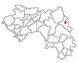
Mandiana is a town located in eastern Guinea. It is the capital of Mandiana Prefecture. As of 2014 the town and surrounding sub-prefecture had a population of 25,791 people. [1]
There are notable gold reserves in the area. It is part of the Birimian rocks, of the Ashanti Gold Belt. It is situated in the Bougouni basin and is underlain by sedimentary rocks of the Upper Birimian Group. The Morila-Syama Gold Belt (known as Morila mine) is located towards the east of the Bougouni basin and is one of the largest gold mines in the area.
- ^ "Guinea". Institut National de la Statistique, Guinea, accessed via Geohive. Archived from the original on 24 November 2015. Retrieved 12 September 2014.
10°38′N 8°41′W / 10.633°N 8.683°W
Mandiana | |
|---|---|
Sub-prefecture and town | |
 | |
| Coordinates: 10°38′N 8°41′W / 10.633°N 8.683°W | |
| Country | |
| Region | Kankan Region |
| Prefecture | Mandiana Prefecture |
| Government | |
| • Mayor | Ibrahima Sira Diakité |
| Population (2014) | |
| • Total | 25,791 |
Mandiana is a town located in eastern Guinea. It is the capital of Mandiana Prefecture. As of 2014 the town and surrounding sub-prefecture had a population of 25,791 people. [1]
There are notable gold reserves in the area. It is part of the Birimian rocks, of the Ashanti Gold Belt. It is situated in the Bougouni basin and is underlain by sedimentary rocks of the Upper Birimian Group. The Morila-Syama Gold Belt (known as Morila mine) is located towards the east of the Bougouni basin and is one of the largest gold mines in the area.
- ^ "Guinea". Institut National de la Statistique, Guinea, accessed via Geohive. Archived from the original on 24 November 2015. Retrieved 12 September 2014.
10°38′N 8°41′W / 10.633°N 8.683°W

