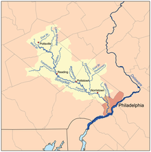
Manatawny Creek is an 18.2-mile-long (29.3 km) [1] tributary of the Schuylkill River in Pennsylvania in the United States. [2]
Etymology
The name of the creek comes from the Lenape (or Delaware Indian) term Man'en'tau'wata'wik. Some early sources state that the term translates to "where we drank liquor", [3] but later sources disagree with that interpretation, putting the meaning closer to "here we drink" or "drink-at-uninhabited-place," without reference to liquor. [4] [5] [6]
Course
The tributary Ironstone Creek joins the Manatawny at Pine Forge. Manatawny Creek is formed by the confluence of Bieber Creek and Pine Creek just below Lobachsville.
Manatawny Creek joins the Schuylkill River at Pottstown in Montgomery County. [2]
Bridges
- The Pleasantville Bridge crosses Manatawny Creek at Oley Township in Berks County.
See also
References
- ^ U.S. Geological Survey. National Hydrography Dataset high-resolution flowline data. The National Map Archived 2012-03-29 at the Wayback Machine, accessed April 1, 2011
- ^ a b Gertler, Edward. Keystone Canoeing, Seneca Press, 2004. ISBN 0-9749692-0-6
- ^ Wagner, A. E.; Balthaser, Francis Wilhauer; Hoch, D. K. (1913). The Story of Berks County (Pennsylvania). Eagle Book and Job Press. p. 28.
- ^ Brinton, Daniel G., C.F. Denke, and Albert Anthony. A Lenâpé - English Dictionary. Biblio Bazaar, 2009. ISBN 978-1103149223, p. 139.
- ^ Nestor, Sandy (2015-05-07). Indian Placenames in America. McFarland. ISBN 978-0-7864-9339-5.
- ^ Lindeström, Peter Mårtensson (1979). Geographia Americae: With an Account of the Delaware Indians : Based on Surveys and Notes Made in 1654-1656. Arno Press. ISBN 978-0-405-11648-3.
External links
40°14′33″N 75°39′32″W / 40.2424°N 75.6588°W