| Malše Maltsch | |
|---|---|
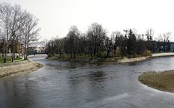
 Confluence of the Malše and Vltava rivers in
České Budějovice | |
| Location | |
| Countries | |
|
Regions/ States | |
| Physical characteristics | |
| Source | |
| • location | Sandl, Gratzen Mountains, Austria |
| • elevation | 985 m (3,232 ft) |
| Mouth | |
• location | Vltava |
• coordinates | 48°58′22″N 14°28′12″E / 48.97278°N 14.47000°E |
• elevation | 384 m (1,260 ft) |
| Length | 96.0 km (59.7 mi) |
| Basin size | 979.1 km2 (378.0 sq mi) |
| Discharge | |
| • average | 7.26 m3/s (256 cu ft/s) near the estuary |
| Basin features | |
| Progression | Vltava→ Elbe→ North Sea |
The Malše ( German: Maltsch) is a river in the Czech Republic and Austria, a right tributary of the Vltava River. It flows through Upper Austria and through the South Bohemian Region. It is 96.0 km (59.7 mi) long.
Etymology
The name is derived from the personal name Malch. The land through which the river flows once belonged to someone of that name. [1]
Characteristic

The Malše originates in the territory of Sandl in the Gratzen Mountains at the elevation of 985 m (3,232 ft), on the slope of the Viehberg mountain, and flows to České Budějovice, where it enters the Vltava River at the elevation of 384 m (1,260 ft). The river is 96.0 km (59.7 mi) long, of which 89.3 km (55.5 mi) is in the Czech Republic (including the 22 km (14 mi) stretch that forms the Austrian-Czech border). Its drainage basin has an area of 979.1 km2 (378.0 sq mi), of which 869.2 km2 (335.6 sq mi) is in the Czech Republic. [2] [3]
The longest tributaries of the Malše are:
| Tributary | Length (km) | River km | Side |
|---|---|---|---|
| Stropnice | 58.4 | 16.6 | right |
| Černá | 29.3 | 44.7 | right |
Settlements
The most notable settlement on the river is the city of České Budějovice. In Austria, the river flows past the territories of Sandl, Windhaag bei Freistadt and Leopoldschlag, then turns north into the hinterland of the Czech Republic. The river then flows through the municipal territories of Dolní Dvořiště, Bujanov, Kaplice, Soběnov, Svatý Jan nad Malší, Velešín, Římov, Doudleby, Plav, Vidov, Roudné and České Budějovice.
Bodies of water
The largest body of water on the Malše and in its whole basin area is the Římov Reservoir with an area of 201 ha (500 acres). It serves as a drinking water reservoir for České Budějovice and the surrounding area. There are 179 bodies of water larger than 1 ha in the basin area. [2]
See also
References
- ^ Loucká, Pavla (1997-09-05). "Řeky si pojmenovali nejdřív" (in Czech). Vesmír. Retrieved 2023-10-20.
- ^ a b "Základní charakteristiky toku Malše a jeho povodí" (in Czech). T. G. Masaryk Water Research Institute. Retrieved 2023-10-20.
- ^ "Řeka Malše – pravostranný přítok Vltavy" (in Czech). CzechTourism. Retrieved 2023-10-20.
External links
- River flow at Roudné station – Flood Warning and Forecasting Service of the Czech Hydrometeorological Institute
| Malše Maltsch | |
|---|---|
 Confluence of the Malše and Vltava rivers in
České Budějovice | |
| Location | |
| Countries | |
|
Regions/ States | |
| Physical characteristics | |
| Source | |
| • location | Sandl, Gratzen Mountains, Austria |
| • elevation | 985 m (3,232 ft) |
| Mouth | |
• location | Vltava |
• coordinates | 48°58′22″N 14°28′12″E / 48.97278°N 14.47000°E |
• elevation | 384 m (1,260 ft) |
| Length | 96.0 km (59.7 mi) |
| Basin size | 979.1 km2 (378.0 sq mi) |
| Discharge | |
| • average | 7.26 m3/s (256 cu ft/s) near the estuary |
| Basin features | |
| Progression | Vltava→ Elbe→ North Sea |
The Malše ( German: Maltsch) is a river in the Czech Republic and Austria, a right tributary of the Vltava River. It flows through Upper Austria and through the South Bohemian Region. It is 96.0 km (59.7 mi) long.
Etymology
The name is derived from the personal name Malch. The land through which the river flows once belonged to someone of that name. [1]
Characteristic

The Malše originates in the territory of Sandl in the Gratzen Mountains at the elevation of 985 m (3,232 ft), on the slope of the Viehberg mountain, and flows to České Budějovice, where it enters the Vltava River at the elevation of 384 m (1,260 ft). The river is 96.0 km (59.7 mi) long, of which 89.3 km (55.5 mi) is in the Czech Republic (including the 22 km (14 mi) stretch that forms the Austrian-Czech border). Its drainage basin has an area of 979.1 km2 (378.0 sq mi), of which 869.2 km2 (335.6 sq mi) is in the Czech Republic. [2] [3]
The longest tributaries of the Malše are:
| Tributary | Length (km) | River km | Side |
|---|---|---|---|
| Stropnice | 58.4 | 16.6 | right |
| Černá | 29.3 | 44.7 | right |
Settlements
The most notable settlement on the river is the city of České Budějovice. In Austria, the river flows past the territories of Sandl, Windhaag bei Freistadt and Leopoldschlag, then turns north into the hinterland of the Czech Republic. The river then flows through the municipal territories of Dolní Dvořiště, Bujanov, Kaplice, Soběnov, Svatý Jan nad Malší, Velešín, Římov, Doudleby, Plav, Vidov, Roudné and České Budějovice.
Bodies of water
The largest body of water on the Malše and in its whole basin area is the Římov Reservoir with an area of 201 ha (500 acres). It serves as a drinking water reservoir for České Budějovice and the surrounding area. There are 179 bodies of water larger than 1 ha in the basin area. [2]
See also
References
- ^ Loucká, Pavla (1997-09-05). "Řeky si pojmenovali nejdřív" (in Czech). Vesmír. Retrieved 2023-10-20.
- ^ a b "Základní charakteristiky toku Malše a jeho povodí" (in Czech). T. G. Masaryk Water Research Institute. Retrieved 2023-10-20.
- ^ "Řeka Malše – pravostranný přítok Vltavy" (in Czech). CzechTourism. Retrieved 2023-10-20.
External links
- River flow at Roudné station – Flood Warning and Forecasting Service of the Czech Hydrometeorological Institute