Mafaijijo | |
|---|---|
| Coordinates: 18°3′S 44°15′E / 18.050°S 44.250°E | |
| Country | |
| Region | Melaky |
| District | Maintirano |
| Government | |
| • Mayor | Raymond Tsiresy |
| Elevation | 60 m (200 ft) |
| Population (2001)
[3] | |
| • Total | 5,000 |
| Time zone | UTC3 ( EAT) |
| Postal code | 413 |
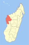
Mafaijijo is a rural municipality in western Madagascar. It belongs to the district of Maintirano, which is a part of Melaky Region. The population of the commune was estimated to be approximately 5,000 in 2001 commune census. [3]
Only primary schooling is available. Farming and raising livestock provides employment for 40% and 60% of the working population. The most important crop is sugarcane, while other important products are bananas, maize and tomatoes. [3]
Roads
The unpaved National road 8a. [4]
References
- ^ Les yeux du maire
- ^ Estimated based on DEM data from Shuttle Radar Topography Mission
- ^ a b c "ILO census data". Cornell University. 2002. Retrieved 2008-03-04.
- ^ L'Express de Madagascar: Routes apres Cheneso
18°3′S 44°15′E / 18.050°S 44.250°E

