Machulishchy
| |
|---|---|
 Orthodox church of St. Pantaleon | |
 Machulishchy Location of Machulishi in Belarus | |
| Coordinates: 53°46′53″N 27°35′45″E / 53.78139°N 27.59583°E | |
| Country | Belarus |
| Region | Minsk Region |
| District | Minsk District |
| Founded | 1590 |
| Elevation | 228 m (748 ft) |
| Population (2023)
[1] | |
| • Total | 10,474 |
| Time zone | UTC+3 ( MSK) |
| Postal code | 223012 |
| License plate | 5 |
| Website | Official website |
Machulishchy [a] ( Belarusian: Мачулішчы, romanized: Mačuliščy; [b] Russian: Мачулищи, romanized: Machulishchi; Polish: Moczuliszcze) is an urban-type settlement in Minsk District, Minsk Region, Belarus. [1] In 2010, it had a population of 7,300. [2] As of 2023, it has a population of 10,474. [1]
History
The settlement was first mentioned in 1590. In 1997, it received the status of urban-type settlement ( Russian: городской посёлок).
Geography
Situated in southern suburb of Minsk, Machulishchy is part of its urban area and one of its main towns also with Zaslawye and Fanipal. It is served by a railway station on the Minsk- Babruysk- Gomel and by the M1 highway. A major Soviet air base operated adjacent to the west side of the town during the Cold War.
Gallery
-
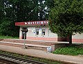 Railway station
 -
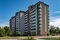 Multi-storeyed buildings
 -
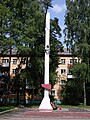 Memorial obelisk devoted to World War II veterans
 -
 House of culture
 -
 Older buildings

_p04.jpg)

_p26.jpg)
_p10.jpg)
Notes
References
- ^ a b c "Численность населения на 1 января 2023 г. и среднегодовая численность населения за 2022 год по Республике Беларусь в разрезе областей, районов, городов, поселков городского типа". belsat.gov.by. Archived from the original on 17 April 2023. Retrieved 29 August 2023.
- ^ (in Russian) 2010 statistics of Belarus Archived 2010-10-30 at the Wayback Machine, rar format ( Belstat)
External links
![]() Media related to
Machulishchy at Wikimedia Commons
Media related to
Machulishchy at Wikimedia Commons
- (in Russian) Machulishchy official website
| Cities |  | |
|---|---|---|
| Urban-type settlement | ||
| Rural councils (sieĺsaviet) | ||
| Districts ( raiony) |  | |
|---|---|---|
| Cities and towns | ||
1 Administrative center of Minsk Region but administratively separated | ||
Machulishchy
| |
|---|---|
|
Orthodox church of St. Pantaleon | |
Machulishchy Location of Machulishi in Belarus | |
| Coordinates: 53°46′53″N 27°35′45″E / 53.78139°N 27.59583°E | |
| Country | Belarus |
| Region | Minsk Region |
| District | Minsk District |
| Founded | 1590 |
| Elevation | 228 m (748 ft) |
| Population (2023)
[1] | |
| • Total | 10,474 |
| Time zone | UTC+3 ( MSK) |
| Postal code | 223012 |
| License plate | 5 |
| Website | Official website |
Machulishchy [a] ( Belarusian: Мачулішчы, romanized: Mačuliščy; [b] Russian: Мачулищи, romanized: Machulishchi; Polish: Moczuliszcze) is an urban-type settlement in Minsk District, Minsk Region, Belarus. [1] In 2010, it had a population of 7,300. [2] As of 2023, it has a population of 10,474. [1]
History
The settlement was first mentioned in 1590. In 1997, it received the status of urban-type settlement ( Russian: городской посёлок).
Geography
Situated in southern suburb of Minsk, Machulishchy is part of its urban area and one of its main towns also with Zaslawye and Fanipal. It is served by a railway station on the Minsk- Babruysk- Gomel and by the M1 highway. A major Soviet air base operated adjacent to the west side of the town during the Cold War.
Gallery
-
Railway station
-
Multi-storeyed buildings
-
Memorial obelisk devoted to World War II veterans
-
House of culture
-
Older buildings
Notes
References
- ^ a b c "Численность населения на 1 января 2023 г. и среднегодовая численность населения за 2022 год по Республике Беларусь в разрезе областей, районов, городов, поселков городского типа". belsat.gov.by. Archived from the original on 17 April 2023. Retrieved 29 August 2023.
- ^ (in Russian) 2010 statistics of Belarus Archived 2010-10-30 at the Wayback Machine, rar format ( Belstat)
External links
![]() Media related to
Machulishchy at Wikimedia Commons
Media related to
Machulishchy at Wikimedia Commons
- (in Russian) Machulishchy official website
| Cities | | |
|---|---|---|
| Urban-type settlement | ||
| Rural councils (sieĺsaviet) | ||
| Districts ( raiony) | | |
|---|---|---|
| Cities and towns | ||
1 Administrative center of Minsk Region but administratively separated | ||