Photos • Location
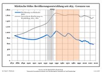
Development of population since 1875 within the current boundaries (Blue line: Population; Dotted line: Comparison to population development of Brandenburg state; Grey background: Time of Nazi rule; Red background: Time of communist rule)

Märkische Höhe | |
|---|---|
 Church | |
Location of Märkische Höhe within Märkisch-Oderland district 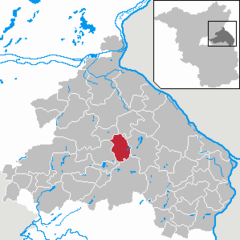 | |
 Märkische Höhe  Märkische Höhe | |
| Coordinates: 52°37′30″N 14°07′30″E / 52.62500°N 14.12500°E | |
| Country | Germany |
| State | Brandenburg |
| District | Märkisch-Oderland |
| Municipal assoc. | Märkische Schweiz |
| Subdivisions | 3 Ortsteile |
| Government | |
| • Mayor (2024–29) | Käte Roos [1] |
| Area | |
| • Total | 34.27 km2 (13.23 sq mi) |
| Elevation | 46 m (151 ft) |
| Population (2022-12-31)
[2] | |
| • Total | 606 |
| • Density | 18/km2 (46/sq mi) |
| Time zone | UTC+01:00 ( CET) |
| • Summer ( DST) | UTC+02:00 ( CEST) |
| Postal codes | 15377 |
| Dialling codes | 033437 |
| Vehicle registration | MOL |
Märkische Höhe is a municipality in the district Märkisch-Oderland, in Brandenburg, Germany.
|
|
- ^ Landkreis Märkisch-Oderland Wahl der Bürgermeisterin / des Bürgermeisters. Retrieved 10 July 2024.
- ^ "Bevölkerungsentwicklung und Bevölkerungsstandim Land Brandenburg Dezember 2022" (PDF). Amt für Statistik Berlin-Brandenburg (in German). June 2023.
- ^ Detailed data sources are to be found in the Wikimedia Commons. Population Projection Brandenburg at Wikimedia Commons
![]() Media related to
Märkische Höhe at Wikimedia Commons
Media related to
Märkische Höhe at Wikimedia Commons
| International | |
|---|---|
| National | |
|
| This Brandenburg location article is a stub. You can help Wikipedia by expanding it. |
Märkische Höhe | |
|---|---|
|
Church | |
Location of Märkische Höhe within Märkisch-Oderland district | |
Märkische Höhe Märkische Höhe | |
| Coordinates: 52°37′30″N 14°07′30″E / 52.62500°N 14.12500°E | |
| Country | Germany |
| State | Brandenburg |
| District | Märkisch-Oderland |
| Municipal assoc. | Märkische Schweiz |
| Subdivisions | 3 Ortsteile |
| Government | |
| • Mayor (2024–29) | Käte Roos [1] |
| Area | |
| • Total | 34.27 km2 (13.23 sq mi) |
| Elevation | 46 m (151 ft) |
| Population (2022-12-31)
[2] | |
| • Total | 606 |
| • Density | 18/km2 (46/sq mi) |
| Time zone | UTC+01:00 ( CET) |
| • Summer ( DST) | UTC+02:00 ( CEST) |
| Postal codes | 15377 |
| Dialling codes | 033437 |
| Vehicle registration | MOL |
Märkische Höhe is a municipality in the district Märkisch-Oderland, in Brandenburg, Germany.
|
|
- ^ Landkreis Märkisch-Oderland Wahl der Bürgermeisterin / des Bürgermeisters. Retrieved 10 July 2024.
- ^ "Bevölkerungsentwicklung und Bevölkerungsstandim Land Brandenburg Dezember 2022" (PDF). Amt für Statistik Berlin-Brandenburg (in German). June 2023.
- ^ Detailed data sources are to be found in the Wikimedia Commons. Population Projection Brandenburg at Wikimedia Commons
![]() Media related to
Märkische Höhe at Wikimedia Commons
Media related to
Märkische Höhe at Wikimedia Commons
| International | |
|---|---|
| National | |
|
| This Brandenburg location article is a stub. You can help Wikipedia by expanding it. |