Lubraniec | |
|---|---|
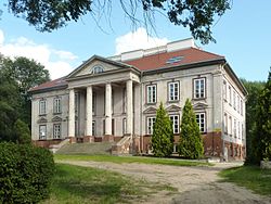
 The palace, built 1827 | |
| Coordinates: 52°32′31″N 18°50′8″E / 52.54194°N 18.83556°E | |
| Country | |
| Voivodeship | Kuyavian-Pomeranian |
| County | Włocławek |
| Gmina | Lubraniec |
| Area | |
| • Total | 1.97 km2 (0.76 sq mi) |
| Population (2010)
[1] | |
| • Total | 3,130 |
| • Density | 1,600/km2 (4,100/sq mi) |
| Time zone | UTC+1 ( CET) |
| • Summer ( DST) | UTC+2 ( CEST) |
| Postal code | 87-890 |
| Vehicle registration | CWL |
| Website | http://www.lubraniec.pl |
Lubraniec [luˈbraɲɛt͡s] is a town in central Poland, with 3,130 inhabitants (2010). [1] It is located in the historic region of Kuyavia.
History
| Year | Pop. | ±% |
|---|---|---|
| 1921 | 2,196 | — |
| 1931 | 2,559 | +16.5% |
| 2010 | 3,130 | +22.3% |
| Source: [2] [3] [1] | ||
Lubraniec was the ancestral seat of the Lubrański noble family. [4] Lubraniec was granted town rights in 1509 by King Sigismund I the Old. [4] It was a private town, [4] administratively located in the Brześć Kujawski Voivodeship in the Greater Poland Province of the Kingdom of Poland. After the Lubrański family became extinct, the town passed to the Dąbski family. [4] Paweł Dąbski, castellan of Brześć Kujawski, granted various privileges to local Jews, confirmed in 1780 by King Stanisław August Poniatowski. [4]
Following the joint German-Soviet invasion of Poland, which started World War II in September 1939, the village was occupied by Germany until 1945. In 1941, the occupiers carried out expulsions of 300 Poles, who were deported to forced labour in Germany, while their houses were handed over to German colonists as part of the Lebensraum policy. [5]
International relations
Twin towns and sister cities
Lubraniec is a twinned with Dutch Winsum.
References
- ^ a b c Stan i struktura ludności oraz ruch naturalny w przekroju terytorialnym w 2010 r. (PDF) (in Polish). Warszawa: Główny Urząd Statystyczny. 2011. p. 54. Archived from the original (PDF) on 13 November 2011.
- ^ Skorowidz miejscowości Rzeczypospolitej Polskiej (in Polish). Vol. I. Warszawa: Główny Urząd Statystyczny. 1925. p. 197.
- ^ Wiadomości Statystyczne Głównego Urzędu Statystycznego (in Polish). Vol. X. Warszawa: Główny Urząd Statystyczny. 1932. p. 200.
- ^
a
b
c
d
e Słownik geograficzny Królestwa Polskiego i innych krajów słowiańskich, Tom V (in Polish). Warszawa. 1884. p. 454.
{{
cite book}}
: CS1 maint: location missing publisher ( link) - ^ Wardzyńska, Maria (2017). Wysiedlenia ludności polskiej z okupowanych ziem polskich włączonych do III Rzeszy w latach 1939-1945 (in Polish). Warszawa: IPN. pp. 292, 294. ISBN 978-83-8098-174-4.
Lubraniec | |
|---|---|
 The palace, built 1827 | |
| Coordinates: 52°32′31″N 18°50′8″E / 52.54194°N 18.83556°E | |
| Country | |
| Voivodeship | Kuyavian-Pomeranian |
| County | Włocławek |
| Gmina | Lubraniec |
| Area | |
| • Total | 1.97 km2 (0.76 sq mi) |
| Population (2010)
[1] | |
| • Total | 3,130 |
| • Density | 1,600/km2 (4,100/sq mi) |
| Time zone | UTC+1 ( CET) |
| • Summer ( DST) | UTC+2 ( CEST) |
| Postal code | 87-890 |
| Vehicle registration | CWL |
| Website | http://www.lubraniec.pl |
Lubraniec [luˈbraɲɛt͡s] is a town in central Poland, with 3,130 inhabitants (2010). [1] It is located in the historic region of Kuyavia.
History
| Year | Pop. | ±% |
|---|---|---|
| 1921 | 2,196 | — |
| 1931 | 2,559 | +16.5% |
| 2010 | 3,130 | +22.3% |
| Source: [2] [3] [1] | ||
Lubraniec was the ancestral seat of the Lubrański noble family. [4] Lubraniec was granted town rights in 1509 by King Sigismund I the Old. [4] It was a private town, [4] administratively located in the Brześć Kujawski Voivodeship in the Greater Poland Province of the Kingdom of Poland. After the Lubrański family became extinct, the town passed to the Dąbski family. [4] Paweł Dąbski, castellan of Brześć Kujawski, granted various privileges to local Jews, confirmed in 1780 by King Stanisław August Poniatowski. [4]
Following the joint German-Soviet invasion of Poland, which started World War II in September 1939, the village was occupied by Germany until 1945. In 1941, the occupiers carried out expulsions of 300 Poles, who were deported to forced labour in Germany, while their houses were handed over to German colonists as part of the Lebensraum policy. [5]
International relations
Twin towns and sister cities
Lubraniec is a twinned with Dutch Winsum.
References
- ^ a b c Stan i struktura ludności oraz ruch naturalny w przekroju terytorialnym w 2010 r. (PDF) (in Polish). Warszawa: Główny Urząd Statystyczny. 2011. p. 54. Archived from the original (PDF) on 13 November 2011.
- ^ Skorowidz miejscowości Rzeczypospolitej Polskiej (in Polish). Vol. I. Warszawa: Główny Urząd Statystyczny. 1925. p. 197.
- ^ Wiadomości Statystyczne Głównego Urzędu Statystycznego (in Polish). Vol. X. Warszawa: Główny Urząd Statystyczny. 1932. p. 200.
- ^
a
b
c
d
e Słownik geograficzny Królestwa Polskiego i innych krajów słowiańskich, Tom V (in Polish). Warszawa. 1884. p. 454.
{{
cite book}}
: CS1 maint: location missing publisher ( link) - ^ Wardzyńska, Maria (2017). Wysiedlenia ludności polskiej z okupowanych ziem polskich włączonych do III Rzeszy w latach 1939-1945 (in Polish). Warszawa: IPN. pp. 292, 294. ISBN 978-83-8098-174-4.


