Photos • Location
Lohača | |
|---|---|
 | |
| Coordinates: 45°49′48.03″N 14°12′36.25″E / 45.8300083°N 14.2100694°E | |
| Country |
|
| Traditional region | Inner Carniola |
| Statistical region | Littoral–Inner Carniola |
| Municipality | Postojna |
| Area | |
| • Total | 1.47 km2 (0.57 sq mi) |
| Elevation | 735.3 m (2,412.4 ft) |
| Population (2002) | |
| • Total | 25 |
| [1] | |
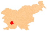
Lohača (pronounced [lɔˈxaːtʃa]) is a small village in the hills west of Planina in the Municipality of Postojna in the Inner Carniola region of Slovenia. [2]
History
Lohača was administratively separated from Strmca in 1994 and made an independent settlement. [3]
References
External links
-
 Media related to
Lohača at Wikimedia Commons
 - Lohača on Geopedia
Lohača | |
|---|---|
 | |
| Coordinates: 45°49′48.03″N 14°12′36.25″E / 45.8300083°N 14.2100694°E | |
| Country |
|
| Traditional region | Inner Carniola |
| Statistical region | Littoral–Inner Carniola |
| Municipality | Postojna |
| Area | |
| • Total | 1.47 km2 (0.57 sq mi) |
| Elevation | 735.3 m (2,412.4 ft) |
| Population (2002) | |
| • Total | 25 |
| [1] | |
Lohača (pronounced [lɔˈxaːtʃa]) is a small village in the hills west of Planina in the Municipality of Postojna in the Inner Carniola region of Slovenia. [2]
History
Lohača was administratively separated from Strmca in 1994 and made an independent settlement. [3]
References
External links
-
 Media related to
Lohača at Wikimedia Commons
 - Lohača on Geopedia

