| Lofa | |
|---|---|
| Location | |
| Countries | Guinea and Liberia |
| Physical characteristics | |
| Source | |
| • location | Macenta Prefecture in Guinea |
| • elevation | 940 m (3,080 ft) |
| Mouth | |
• location | Atlantic Ocean south of Robertsport at |
• coordinates | 6°34′26″N 11°3′38″W / 6.57389°N 11.06056°W |
• elevation | 0 m (0 ft) |
| Length | 410 km (250 mi) |
| Basin size | 10,446 km2 (4,033 sq mi) [1] |
| Discharge | |
| • location | Near mouth |
| • average | (Period: 1979–2015) 18.63 km3/a (590 m3/s) [1] |
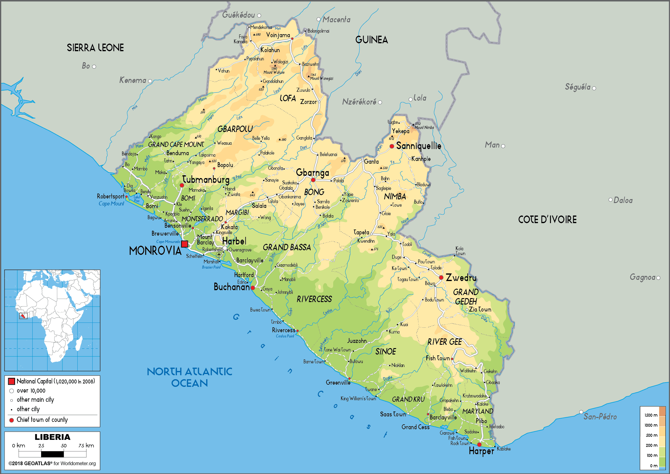
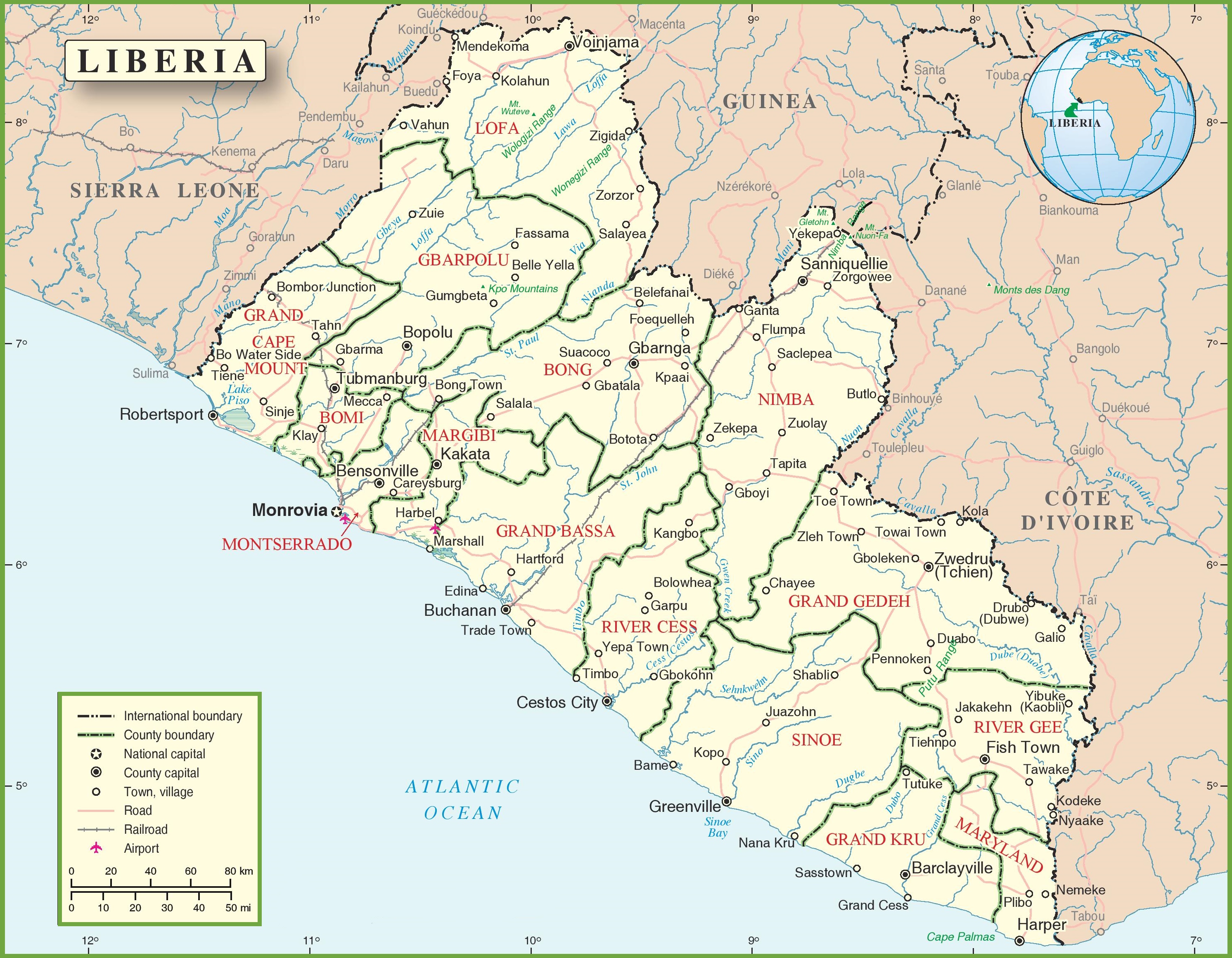
The Lofa or Loffa is a river whose headwaters originate in eastern Guinea northeast of Macenta. The river runs southwest through northeastern Liberia before draining into the North Atlantic Ocean. [2] Historically it has also been known as the Little Cape Mount River. [3] The Lawa River enters the Lofa River in Liberia's Lofa County. [2]
Indigenous species include the pygmy hippopotamus. [4] Several diamond mining concessions along the Lofa River were granted in the late 1950s and early 1960s. [5]
Notes
- ^ a b "River Basins".
- ^
a
b (1)
"Liberia Physical Map". Worldometers. Archived from
the original on 24 June 2020. Retrieved 24 June 2020..
(2) "Liberia Political Map". OnTheWorldMap. Archived from the original on 24 June 2020. Retrieved 24 June 2020.. - ^ Sims, James L.; Seymour, George L.; Anderson, Benjamin J. K.; Fairhead, James (2003). African-American Exploration in West Africa: Four Nineteenth-century Diaries. Indiana University Press. p. 375. ISBN 0-253-34194-9.
- ^ "At last New York has a pair of pygmy hippos" (PDF). The New York Times. 14 July 1912. Retrieved 12 January 2009.
- ^ Greenhalgh, Peter (1985). West African Diamonds. Manchester University Press. pp. 72–73. ISBN 0-7190-1763-7.
| International | |
|---|---|
| National | |
| Lofa | |
|---|---|
| Location | |
| Countries | Guinea and Liberia |
| Physical characteristics | |
| Source | |
| • location | Macenta Prefecture in Guinea |
| • elevation | 940 m (3,080 ft) |
| Mouth | |
• location | Atlantic Ocean south of Robertsport at |
• coordinates | 6°34′26″N 11°3′38″W / 6.57389°N 11.06056°W |
• elevation | 0 m (0 ft) |
| Length | 410 km (250 mi) |
| Basin size | 10,446 km2 (4,033 sq mi) [1] |
| Discharge | |
| • location | Near mouth |
| • average | (Period: 1979–2015) 18.63 km3/a (590 m3/s) [1] |
The Lofa or Loffa is a river whose headwaters originate in eastern Guinea northeast of Macenta. The river runs southwest through northeastern Liberia before draining into the North Atlantic Ocean. [2] Historically it has also been known as the Little Cape Mount River. [3] The Lawa River enters the Lofa River in Liberia's Lofa County. [2]
Indigenous species include the pygmy hippopotamus. [4] Several diamond mining concessions along the Lofa River were granted in the late 1950s and early 1960s. [5]
Notes
- ^ a b "River Basins".
- ^
a
b (1)
"Liberia Physical Map". Worldometers. Archived from
the original on 24 June 2020. Retrieved 24 June 2020..
(2) "Liberia Political Map". OnTheWorldMap. Archived from the original on 24 June 2020. Retrieved 24 June 2020.. - ^ Sims, James L.; Seymour, George L.; Anderson, Benjamin J. K.; Fairhead, James (2003). African-American Exploration in West Africa: Four Nineteenth-century Diaries. Indiana University Press. p. 375. ISBN 0-253-34194-9.
- ^ "At last New York has a pair of pygmy hippos" (PDF). The New York Times. 14 July 1912. Retrieved 12 January 2009.
- ^ Greenhalgh, Peter (1985). West African Diamonds. Manchester University Press. pp. 72–73. ISBN 0-7190-1763-7.
| International | |
|---|---|
| National | |