_(50).jpg)
From 1980 to the present, 81 tropical or subtropical cyclones affected the U.S. state of Texas. According to David Roth of the Weather Prediction Center, a tropical cyclone makes landfall along the coastline about three times every four years, and on any 50 mi (80 km) segment of the coastline a hurricane makes landfall about once every six years. [1]
The most active month is September, with 21 total storms, while no recorded storms have affected Texas during the months of December through May. While the most intense storm in terms of barometric pressure is Hurricane Allen in 1980, Hurricane Harvey in 2017 caused the most fatalities and damages, with $125 billion in Texas. [nb 1] The first storm to impact the state during the period is also Hurricane Allen in August 1980, with the most recent being Hurricane Harvey on August 25, 2017. In terms of wind speed, Hurricane Harvey is the strongest storm to affect the state since 1980, producing maximum sustained winds equivalent to Category 4 status on the SaffirŌĆōSimpson hurricane scale. [1]
During the 1980s, multiple tropical cyclones affected the state, of which six made landfall as hurricanes; three made landfall as major hurricanes. [1] [nb 2] Hurricane Alicia is the most destructive hurricane of the decade, severely impacting the Greater Houston area. The names of all three major hurricanes that impacted Texas during the 1980s were later retired by the World Meteorological Organization. [3] In contrast to the 1980s, during the 1990s only one hurricane, Hurricane Bret, made landfall on the Texas coast. [4] In the next decade five hurricanes would make landfall on Texas. [1] Hurricane Ike, the second costliest hurricane to impact Texas, made landfall during the decade. Other notable systems include Tropical Storm Allison and Hurricane Rita.
1980ŌĆō1984

- August 10, 1980 ŌĆō Hurricane Allen makes landfall near Brownsville as a Category 3 hurricane. A wind gust of 140 mph (230 km/h) is reported in Port Mansfield. Heavy rainfall is reported across South Texas, with a peak of 20.2 in (510 mm) in Kingsville. Nearly all structures on South Padre Island are destroyed. [5] At least 12 tornadoes are also reported as a result of Allen. One damages hangars and aircraft at Robert Mueller Municipal Airport, causing $250 million in damages. [5] [6] Two deaths are directly attributed to Allen, both of which are drownings in the Corpus Christi area, with five others indirectly killed. [1] An estimated $600 million in damages are attributed to Allen. [5]
- September 5, 1980 ŌĆō Tropical Storm Danielle makes landfall near Galveston Bay as a weak tropical storm. As it moves inland, it causes severe and widespread flooding across Texas. Areas are inundated by the rain, peaking at 18.29 in (465 mm) in Nederland. [7] One person is killed due to rains associated with Danielle. [8] [9]
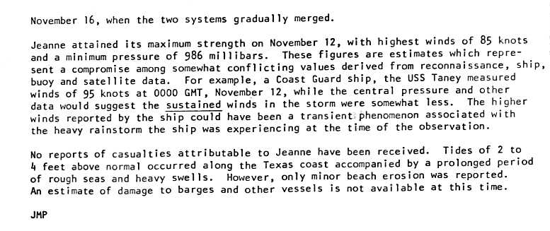
- Mid-November 1980 ŌĆō Hurricane Jeanne over the Western Gulf of Mexico causes tides to rise up to 4 ft (1.2 m) above average along the Texas coast. Coastal flooding also occurs, with the worst being near Galveston. Minimal damage is reported. [10] [11]
- Late-August 1981 ŌĆō Tropical Depression Eight moves ashore northeast Mexico on August 29 and into the United States on August 30. As an ill-defined surface low, a large thunderstorm complex forms near its center that day, which unleashes very heavy rainfall in a 50 mi (80 km) wide band covering a 200 mi (320 km) path from Seguin to north of Houston. The highest rainfall amount reported is from Cheapside, where 18 in (460 mm) falls in a 24ŌĆæhour period ending on the morning of August 31. Five die in the town of Shiner due to the heavy rains. [12] Heavy rain in downtown Hallettsville causes floods and torrential rain, reaching a peak of 5 ft (1.5 m). Significant flooding also occurs along the Lavaca, Guadalupe, and Colorado rivers in Texas. Damages from the floods amount to nearly $21 million. [13]
- October 13, 1981 ŌĆō Hurricane Norma makes landfall on the Pacific coast of Mexico, but its remnants produce 21 in (530 mm) of rain near Dallas-Fort Worth, killing five. [14] Multiple tornadoes touch down in six counties in the region, injuring three. [15] Hurricane Norma causes $50 million in damages and kills three people in Texas. [16]
- September 11, 1982 ŌĆō Tropical Storm Chris makes landfall near Sabine Pass. [17] Before landfall the storm causes tides of 5 to 6 ft (1.5ŌĆō1.8 m) in height. [17] Rainfall from Chris peaks at 0.96 in (24 mm) in Evadale. [18]

- August 18, 1983 ŌĆō Hurricane Alicia makes landfall near Galveston as a Category 3 hurricane. Alicia causes $2.6 billion in damage and 13 fatalities, along with an estimated 5,805 residential structures either heavily damaged or destroyed. [1] [19] In advance of Alicia, offshore drilling platforms are evacuated. [20] At one point during the storm, the entire city of Galveston loses power, with 250,000 electricity customers in Houston losing power as well. [21] At the time, Hurricane Alicia is the costliest hurricane to impact Texas, not adjusting for inflation. [1] High rainfall totals are reported across Southeast Texas, with a peak of 9.5 in (240 mm) of rain in Liberty. The peak wind gust in Galveston is 102 mph (164 km/h). [19] An estimated storm surge of up to 12 ft (3.7 m) is estimated in Galveston Bay. Alicia also causes 23 tornadoes, concentrated around the Galveston and Tyler areas. [19] [22]
- August 28, 1983 ŌĆō Hurricane Barry, a Category 1, makes landfall just south of Brownsville and forces the evacuation of 4,000 people, but causes minor damage. [23]
- Mid-October 1983 ŌĆō The remnants of Hurricane Tico from the Eastern Pacific cause rainfall over much of Texas, most of which is in northern Texas, where rainfall peaks at 9.59 in (0.244 m) in Quanah. [18] [24] Numerous road closures take place due to the floods caused by the remnants of Tico. [25] In Val Verde County, 100 people are evacuated due to the heavy rain. Tico's remnants kill one person and cause $93 million in damages. [1]
- Mid-September 1984 ŌĆō The remnants of Tropical Storm Edouard cause severe flooding in South Texas, where some isolated locations receive totals in excess of 20 in (510 mm). [26]
1985ŌĆō1989
- October 11, 1985 ŌĆō The remnants of Hurricane Waldo produce rainfall over most of West Texas, with multiple rain totals of at least 5 in (130 mm). [27]
- Late-October 1985 ŌĆō Hurricane Juan dumps up to 10 in (250 mm) of rain in extreme southeastern Texas, peaking at 12.84 in (326 mm) in Alto, killing one coastal resident. [28] [29] The rains cause widespread floods that lead to road closures, and gusty winds cause some power outages. [30] Coastal flooding is also reported as a result of high tides caused by Juan. [30]
- June 26, 1986 ŌĆō Hurricane Bonnie makes landfall near High Island in Southeast Texas as a Category 1 hurricane, killing four people in Texas [1] and producing heavy rainfall that causes street flooding. Rainfall peaks at 13 in (330 mm), with many areas picking up at least 10 in (250 mm). [31] Bonnie also spawns four tornadoes in Texas. [32]
- August 6, 1986 ŌĆō A tropical depression produces rain over South Texas with a maximum total of 4.5 in (110 mm) near Refugio. [33]
- September 23, 1986 ŌĆō The remnants of Hurricane Newton produce 1 in (25 mm) rainfall totals over the Texas Panhandle with an area of 3 in (76 mm) near the border between New Mexico and Texas, peaking at 3.97 in (101 mm) in Wharton. [34] [35]
- Early-October 1986 ŌĆō The remnants of Hurricane Paine produce widespread rainfall over western and northern Texas, most of which receives at least an inch of rain, with 10.39 in (264 mm) in Wellington. [18] [36]
- October 22, 1986 ŌĆō The remnants of Hurricane Roslyn produce rainfall over much of southern and eastern Texas, with the heaviest totals along the middle Texas coast, where rainfall totals exceeds 10 in (250 mm). [37] Roslyn causes low-water crossings and streams to flood. [38]

- August 10, 1987 ŌĆō An unnamed storm makes landfall near High Island, Texas, producing over 1 in (25 mm) of rain to eastern portions of the state, peaking at 4.25 in (108 mm) in Umbarger. [18] [39] [40]
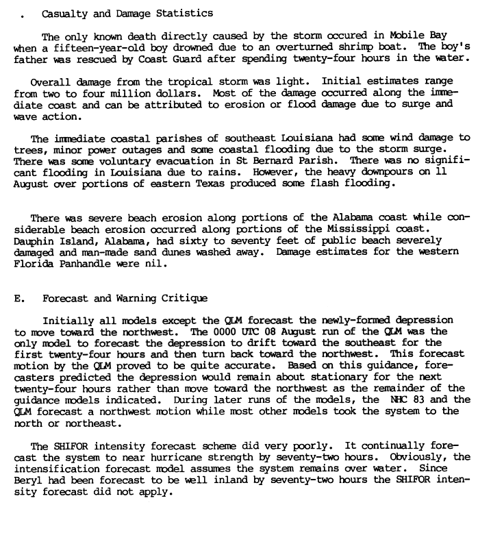
- August 12, 1988 ŌĆō Tropical Storm Beryl produces heavy rainfall over East Texas. Some areas receive 11.8 in (300 mm) of rain, causing localized flash flooding. [41] [42] [43]
- September 2, 1988 ŌĆō Tropical Depression Ten produces heavy rain over Southeast Texas, peaking at 8.16 in (207 mm) in Galveston. [18] [44] [45]
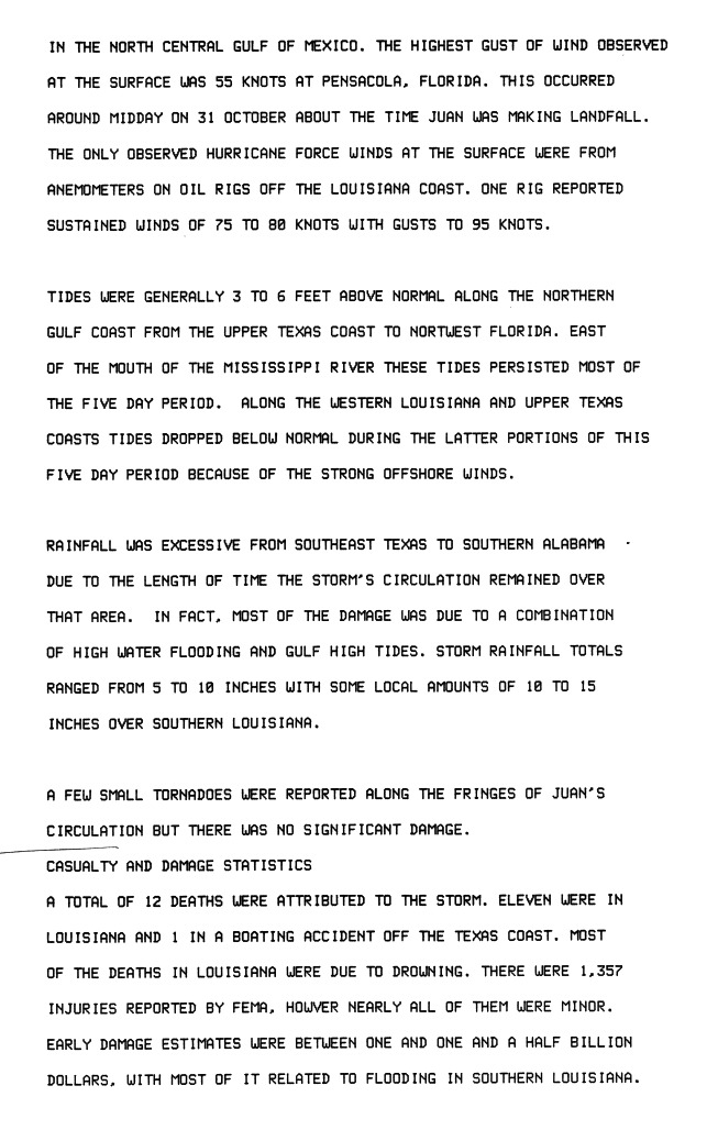
- September 17, 1988 ŌĆō Hurricane Gilbert makes landfall in northern Mexico with winds of 135 mph (217 km/h) and causes tides to rise up to 5 ft (1.5 m) above normal. [1] [46] As a result, beach erosion is reported on Padre Island. [46] Rainfall peaks at 7.45 in (189 mm) in Anson. [18] Minor wind damage is reported from Gilbert. Twenty-nine tornadoes are recorded across Texas, with the worst damage in San Antonio. Gilbert causes three deaths in Texas, all resulting from tornadoes in San Antonio. [47] [48] Damages from Gilbert total to $50 million. [1]
- Late-June 1989 ŌĆō Tropical Storm Allison makes landfall near Freeport, causing three deaths in the state. [49] [50] Tropical Storm Allison produces torrential rainfall across the state, with amounts of more than 10 in (250 mm) over much of the upper Texas coast, peaking at 20.28 in (515 mm) in Orange. [18] [51] Storm surge from the storm measures 7 ft (2.1 m) in Trinity Bay. [46] As a result, beach erosion is reported on Padre Island. [52] Allison causes an estimated $400 million in Texas alone. [51]
- August 1, 1989 ŌĆō Hurricane Chantal makes landfall as a minimal hurricane at High Island, Texas, causing two deaths from flash flooding. [1] [53]
- Early-October 1989 ŌĆō Hurricane Raymond from the East Pacific causes rainfall in northern Texas, peaking at 2.80 in (71 mm) in Yorktown. [18] [54]
- October 16, 1989 ŌĆō Hurricane Jerry affects the Galveston area as a minimal hurricane. The storm kills three people when a car is blown off The Galveston seawall. Jerry causes $70 million in damage and kills three. [1] [55]
1990ŌĆō1994

- October 3, 1990 ŌĆō Tropical Storm Rachel's remnants affect portions of West Texas. [56] Roads in Big Bend National Park are closed due to high water levels. Rainfall peaks at 1.5 in (38 mm) in Lubbock, causing minor street flooding, which leads to several car accidents. [56]
- July 6, 1991 ŌĆō Tropical Depression Two causes isolated rainfall over Texas, with a maximum total of 3 in (76 mm) reported within the vicinity of Anahuac. [57]
- August 24, 1992 ŌĆō The remnants of Hurricane Lester, which originated from the East Pacific, cause rainfall in North Texas, amounting up to 3 in (76 mm) in locations and peaking at 3.54 in (90 mm) in Chisos Basin. [18] [58]
- June 20, 1993 ŌĆō Tropical Storm Arlene makes landfall near Padre Island. Heavy beach erosion occurs as a result of the storm. Arlene causes $55 million in damage and its flooding rains kill one person. [59] [60]
- September 14, 1993 ŌĆō Hurricane Lidia moves into Texas before being absorbed by a cold front near Austin. [61] Lida's remnants cause moderate rainfall across the state, peaking at 7.3 in (190 mm) in Denton. [18] The combination of the front and the hurricane's remnants trigger tornadoes, and one causes more than $8 million in damages. Five people are injured in Arlington after a roof is torn off their hotel. [62]
- Mid-October 1994 ŌĆō The remnants of Hurricane Rosa cause severe flooding in Texas. [63] In some locations the flood is considered a 100-year event, peaking at 29.40 in (747 mm) in Cypress. [63] The floods kill 22 people and cause $700 million in damages. [63]
1995ŌĆō1999
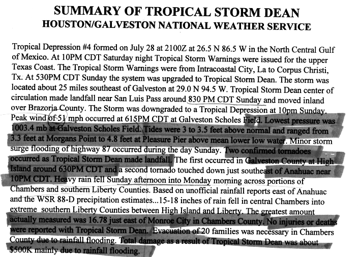
- July 31, 1995 ŌĆō Tropical Storm Dean makes landfall near Freeport. Dean drops nearly 17 in (430 mm) of rain in Monroe City. [64] The rainfall results in moderate localized damage. [65]
- August 12, 1995 ŌĆō Tropical Storm Gabrielle makes landfall just south of the TexasŌĆōMexico border as a strong tropical storm, producing rainfall in southern Texas, peaking at 6.26 in (159 mm) in Weslaco. [66] Slight storm surge associated with Gabrielle floods beaches along the southern Texas coast. [18] [67]
- September 16, 1995 ŌĆō Hurricane Ismael's remnants move across the Texas Panhandle. Rainfall peaks at 6.57 in (167 mm) in Ransom Canyon, [18] and flash flooding results in the area. [68] [69]
- August 23, 1996 ŌĆō Hurricane Dolly makes landfall near Tampico, Mexico. [70] The storm causes beneficial rainfall in southern Texas, peaking at 5.53 in (140 mm) in Corpus Christi, providing drought relief to the area. [70]
- October 4, 1996 ŌĆō Tropical Storm Josephine forms just offshore of the Texas coast, bringing heavy rain to the state. Rainfall peaks at 10.81 in (275 mm) in Brownsville. [18] The storm, although remaining offshore, causes severe beach erosion across much of the coast. [71] Several houses are lost and up to 65 ft (20 m) of shore-front property on Galveston Island is eroded. [71]
- August 23, 1998 ŌĆō Tropical Storm Charley makes landfall near Port Aransas. Severe inland flooding occurs in Val Verde Country and 13 people are killed. Del Rio records 17 in (430 mm) of rain in 24 hours from the storm, a city record and the most rainfall from a tropical cyclone in Texas since Tropical Storm Claudette in 1979. [72]
- September 11, 1998 ŌĆō Tropical Storm Frances makes landfall north of Corpus Christi on September 11 as a moderately strong tropical storm. Rainfall causes large amounts of flooding in southeast Texas and southwest Louisiana, peaking at 21.76 in (553 mm) in Goose Creek. [18] As a result of the rains, many rivers and bayous overflow. [73] Due to the storm, tides are 5 ft (1.5 m) above average. [74] Frances causes an estimated total of $500 million in property damage. [75]
- Mid-October 1998 ŌĆō Moisture associated with the remnants of Hurricane Madeline results in flooding in Central Texas. [76] The event breaks numerous rain records in the region, including the wettest month for San Antonio since records began in 1885. [73] In addition, 15 rivers exceed the previously known peak flow. [73] The floods kill 31 people. [76] and cause $1.5 billion in damages. [77]
- August 23, 1999 ŌĆō Hurricane Bret makes landfall as a Category 3 hurricane on Padre Island, becoming the first major hurricane to hit Texas since Hurricane Alicia in 1983. [78] As it approaches landfall, large swells cause minor beach erosion along the coast. Along with rainfall from Bret, beaches in Matagorda County are closed due to the high water level. [79] Further inland, heavy rainfall occurs across South Texas, reaching 13.18 in (335 mm) in Sarita. [80] At the height of the storm, power outages cut electricity to an estimated 64,000 customers. [81] Due to the small size of Bret and its landfall in a relatively unpopulated region of the Texas coast, damages from Bret total just $15 million, but it causes four deaths, all of which are attributed to a semi-trailer truck jackknifing in Laredo. [82]
- September 8, 1999 ŌĆō Tropical Depression Seven's remnants produce light rainfall, peaking at 3.35 in (85 mm) in Harlingen. [83]
2000ŌĆō2004

- September 9, 2000 ŌĆō Tropical Depression Nine makes landfall near Sabine Pass, with maximum sustained winds of 30 mph (48 km/h). Minimal damage is reported. [84]
- June 5, 2001 ŌĆō Tropical Storm Allison makes landfall near Freeport. It stalls over eastern Texas for several days, dropping extreme amounts of rain which leads to catastrophic flooding. [85] Allison causes flash flooding in the area, producing widespread street flooding and filling nearby bayous to severe levels. [86] Rainfall peaks at 36.99 in (940 mm) at the Port of Houston. [87] The Texas Medical Center is severely damaged, with losses of up to $2 billion. Patient evacuations and medical services are disrupted due to power outages caused by the storm. [87] Allison causes an estimated $4.8 billion in damages, nearly all of it related to freshwater flooding in the Greater Houston region. [85] Tropical Storm Allison causes 23 deaths in the state, [88] and was the only non-hurricane strength storm to have its name retired until Tropical Storm Erika (did not affect the U.S.) in 2015. [89]
- August 9, 2002 ŌĆō Tropical Storm Bertha makes landfall as a tropical depression near Kingsville, causing isolated rainfall throughout the state. [90] [91]
- September 7, 2002 ŌĆō Tropical Storm Fay makes landfall near Port O'Connor, where it causes heavy rainfall and $450,000 in damage. [92] Rainfall peaks at 18.49 in (470 mm) in Fowlerton. [18] Fay causes five tornadoes, one of which injures three people. Much of the impact takes place in Brazoria County, where over 2,300 homes are damaged. [93]
- June 30, 2003 ŌĆō Tropical Storm Bill causes minor beach erosion on the Bolivar Peninsula. [94]
- July 15, 2003 ŌĆō Hurricane Claudette makes landfall at Matagorda Island near Port O'Connor as a strong Category 1 storm, with maximum sustained winds of 90 mph (140 km/h). Claudette is responsible for one direct death. Inland towns in Texas sustain significant wind damage. Estimated damages total up to $180 million. [95]
- August 16, 2003 ŌĆō Hurricane Erika makes landfall in the Mexican state of Tamaulipas as a minor Category 1 hurricane, causing minor coastal damage and beach erosion in parts of southern Texas. [96]
- August 31, 2003 ŌĆō Tropical Storm Grace makes landfall near San Luis Pass with maximum sustained winds of 40 mph (64 km/h), causing heavy rainfall along the Texas coast and resulting in $113,000 in total damages. [97]
- September 22, 2003 ŌĆō Hurricane Marty from the East Pacific makes landfall in the Mexican state of Baja California Sur. Rainfall associated with the remnants of Marty affects western Texas. [98]
- September 20, 2004 ŌĆō As the remnants of Hurricane Javier move northeast through northwest Mexico, 1 in (25 mm) of rain is reported in western Texas. [99]
- September 24, 2004 ŌĆō Four days after Hurricane Javier affected the state, Hurricane Ivan, having regenerated into a tropical storm in the Gulf of Mexico, makes landfall near Cameron, Louisiana, as a tropical depression. Over 7 in (180 mm) of rain is dropped on eastern Texas. [100]
- October 10, 2004 ŌĆō Tropical Storm Matthew moves ashore in southern Louisiana, producing locally heavy rainfall in eastern Texas, peaking at 6.10 in (155 mm) in Matagorda, but little damage. [18] [101]
2005ŌĆō2009

- July 20, 2005 ŌĆō Hurricane Emily makes landfall in Tamaulipas, Mexico, providing rainfall to drought-affected areas of southern Texas. [102] Rainfall peaks at 5.2 in (130 mm) in Mercedes, and is spread from about 1 to 3 in (25ŌĆō76 mm) elsewhere. [103]
- September 23, 2005 ŌĆō Hurricane Rita makes landfall as a Category 3 hurricane on the border between Louisiana and Texas on September 23. [104] In preparation for its landfall, the largest evacuation in United States history takes place, with over 3 million people evacuating inland. [105] At one point during the storm, 1 million energy customers lose power due to outages. [106] Rita causes a peak of 10.48 in (266 mm) in Center. [18] [107] Major flooding is reported in Port Arthur and Beaumont. Offshore oil platforms throughout Rita's path also suffer significant damage, though the refineries of Houston, originally thought to be at risk, escape the brunt of the storm. Many of the indirect deaths linked to Rita are caused by a single bus fire in mass evacuations out of Houston. [104] Rita causes 59 deaths in the state all told. [1]
- September 2, 2006 ŌĆō The remnants of Hurricane John, an East Pacific storm, cause moderate to heavy rainfall. In northern Texas, moisture from the storm combined with a cold front produces rainfall of over 4 in (100 mm), helping alleviate severe drought. [108] [109]
- September 16, 2006 ŌĆō Hurricane Lane, another East Pacific storm, makes landfall in the Mexican state of Sinaloa. Lane's remnants combine with an upper-level trough over southeast portions of the state, dropping over 5 in (130 mm) of rain in some locations. [110]
- August 16, 2007 ŌĆō Tropical Storm Erin makes landfall near Lamar as a minimal tropical storm. Rainfall peaks in Texas at 10.7 in (270 mm) in Sisterdale. [111] Erin causes nine deaths in the state and causes nearly $49 million in damages. [112] [113]
- September 13, 2007 ŌĆō Hurricane Humberto rapidly intensifies before making landfall just west of the LouisianaŌĆōTexas border with winds of up to 90 mph, dropping up to 14.13 in (359 mm) of rain. [114] The storm kills one person and leaves $50 million in damage. [115]

- July 23, 2008 ŌĆō Hurricane Dolly makes landfall at South Padre Island with winds near 100 mph. A storm surge of 4 ft (1.2 m) is observed across much of the coast of southern Texas. [116] Dolly's remnants cause coastal and inland flooding and over 12 in (300 mm) of rain in some locations, peaking at 15 in (380 mm) in Harlingen. [117] On South Padre Island, moderate structural damage, mostly to roofs, is reported. Tree and utility pole damage is widespread across Cameron County. Widespread power outages are reported across southern Texas as a result of Dolly. [116]
- August 5, 2008 ŌĆō Tropical Storm Edouard makes landfall near Port Arthur with winds near 65 mph. Edouard provides beneficial rain to a drought stricken central Texas. [118]
- September 1, 2008 ŌĆō Hurricane Gustav produces heavy rain to extreme East Texas as it makes landfall in Louisiana as a Category 2 hurricane. [119] The storm causes strong rip currents and minor overwash of the coast. [120]
- September 13, 2008 ŌĆō Hurricane Ike makes landfall at Galveston as a large Category 2 hurricane. Its large size contributes to a storm surge that is as high as 20 ft (6.1 m), [121] which inundates many of the barrier islands off the Texas coast. Many structures on the Bolivar Peninsula are destroyed. [122] Most notably, in Gilchrist all but one house is destroyed by the storm surge. [123] The storm also causes heavy rains where it makes landfall, peaking at 18.9 in (480 mm). [124] At one point, the storm knocks out power to as many as an estimated 2.6 million people. [1] Ike is one of the most destructive hurricanes ever to hit Texas and one of the deadliest, causing $19.3 billion in damages and killing 84 people. [1]
- October 13, 2008 ŌĆō Hurricane Norbert causes moderate rainfall over West Texas after moving inland from the eastern Pacific. [125]
- November 10, 2009 ŌĆō Hurricane Ida causes minimal effects on Texas, producing high tides that lead to road closures. [126]
2010ŌĆō2014

- June 30, 2010 ŌĆō Hurricane Alex makes landfall at Soto la Marina, Tamaulipas in Mexico as a large Category 2 hurricane, bringing heavy rains, wind, and tornadoes to South Texas. [127] The hurricane's remnants also bring heavy rains to portions of the Rio Grande, causing it to exceed record levels. [128]
- July 8, 2010 ŌĆō Tropical Depression Two makes landfall on South Padre Island, dropping 1 to 3 in (25 to 76 mm) of rain in south Texas, peaking at 8.95 in (227 mm) in Chincorro. [129] However, there are no reports of significant damage. [130]
- September 7, 2010 ŌĆō Tropical Storm Hermine makes landfall in northeastern Mexico as a strong tropical storm with 65 mph (105 km/h) winds. [131] A storm surge of 3.4 ft (1.0 m) is reported at Port Aransas as the storm approaches the coast. In the Rio Grande Valley, an estimated 35,000 homes lose power due to Hermine, [132] while in Bexar County, 100,000 customers lose power. [133] Farm crops in the Texas Coastal Bend are also damaged by the strong winds and rain. [134] In addition, numerous roads are closed due to overwash. Hermine kills five people and causes $240 million in damages in the state. [131]
- June 30, 2011 ŌĆō Tropical Storm Arlene makes landfall south of Texas near Cabo Rojo. [135] The outer bands of Arlene produce 1 to 4 in (25ŌĆō102 mm) of rain in southern Texas. [136]
- July 30, 2011 ŌĆō Tropical Storm Don makes landfall near Baffin Bay, Texas before quickly dissipating. The storm produces minimal rainfall in extreme southern Texas, peaking at 2.56 in (65 mm) in Bay City. [137] Cotton farms benefit from the minimal rainfall. [138]
- Early-September 2011 ŌĆō The outer bands of Tropical Storm Lee cause light rain in eastern Texas, peaking at 3.97 in (101 mm) in Nederland. [18] Despite the light rainfall, strong winds further inland help ignite numerous wildfires throughout the state. [139] One of the fires, the Bastrop County Complex fire, destroys 1,700 homes and businesses, becoming the most destructive wildfire in Texas history. [140]
- August 31, 2012 ŌĆō Outer rainbands associated with Hurricane Isaac cause slight rainfall in East Texas, peaking at around 3 in (7.6 cm) near Galveston Bay. [141] Strong winds associated with Isaac's thunderstorms knock down many trees in Trinity County, where wind gusts peak at an estimated 65 mph (105 km/h). [142]
- September 29, 2012 ŌĆō Moisture associated with the remnants of Hurricane Miriam and Tropical Storm Norman brings light rainfall over areas of Texas, slightly alleviating drought conditions. Rainfall in the state measures 1ŌĆō4 in (25ŌĆō102 mm), causing some flash flooding. Combined with a surface trough, the moisture generates severe thunderstorms which later coalesce into a squall line, bringing strong winds which cause numerous reports of window damage. A weather station near Paducah records a peak wind gust of 96 mph (154 km/h). [143]
- Mid-September 2013 ŌĆō As Hurricane Ingrid passes to the south, its outer rainbands drop isolated areas of heavy rainfall across South Texas. Rainfall totals from the bands peak at approximately 3 in (76 mm) near the Texas border with Mexico. [144]
- September 3, 2014 ŌĆō Despite making landfall near Tampico, Mexico, the outer rainbands of Tropical Storm Dolly traverse South Texas, producing rainfall totals peaking at 2.91 in (74 mm) in Hidalgo County. After dissipating, moisture from the remnant system causes additional showers in the area. Urban flooding as a result of poor water drainage occurs in Brownsville, Edinburg, and McAllen. However, the heavy rainfall helps to alleviate some drought conditions in South Texas. [145]
- September 20, 2014 ŌĆō Flooding associated with the remnants of Hurricane Odile kill one sheriff's deputy in Austin. [146]
2015ŌĆō2019

- Mid-June 2015 ŌĆō Tropical Storm Bill makes landfall on Matagorda Island with sustained winds of 60 mph (95 km/h), causing gusts peaking at 53 mph (85 km/h) in Palacios and Port O'Connor in addition to producing a 3 ft (0.9 m) storm surge in Port Lavaca. [147] However, most of Bill's impacts in Texas are associated with heavy rainfall. Several isolated areas receive rainfall in excess of 10 in (25 cm) of rainfall, including a large swath of Victoria County. [148] In Wharton, rainfall peaks at 13.05 in (331 mm). [149]
- October 20ŌĆō24, 2015 ŌĆō Hurricane Patricia's remnants bring heavy rain to Texas. The maximum rainfall total is reported to be 20.87 in (530 mm) in Corsicana. [150] This rain causes the flooding and closure of Interstate 45 in that area. [151]
- September 8, 2016 ŌĆō The remnants of Hurricane Newton bring heavy rains to parts of western Texas, however there are no reports of significant damage.
- June 22, 2017 ŌĆō Tropical Storm Cindy makes landfall near Port Arthur with winds of 45 mph (70 km/h). One fatality takes place in Bolivar Peninsula. [152]
- Late August 2017 ŌĆō Hurricane Harvey makes landfall on San Jos├® Island near Rockport as a Category 4 hurricane on August 26 with sustained winds of 130 mph (215 km/h). [153] The Aransas County Airport in Rockport registers a peak wind gust of 145 mph (233 km/h) within Harvey's eyewall. Extensive wind damage occurs in Rockport and Fulton, with many roofs blown off and walls torn apart; widespread damage also befalls nearby communities. [154] Storm surge inundates areas along San Antonio and Hynes bays under as much as 8ŌĆō10 ft (2.4ŌĆō3.0 m) of water, resulting in major flood conditions. [153] [154] Weak steering currents cause Harvey to slowly meander along the Texas Coastal Plain for several days, subjecting large swaths of the region to prolonged and torrential rainfall from the storm's rainbands. [153] [155] The rains constitute the most prolific rainfall event associated with a tropical cyclone in U.S. history, with the peak rainfall total of 60.58 in (1,539 mm) near Nederland setting the national record for the largest rainfall total measured in connection to a tropical cyclone; [153] at least 18 observing sites report amounts exceeding the previous record for the contiguous U.S. of 48 in (1,200 mm). [156] The unprecedented scale of the rainfall in both extent and magnitude causes catastrophic flooding, displacing approximately 1.8 million people. [153] [155] Bayous in the Greater Houston area rapidly rise and overrun their banks, prompting evacuations and submerging parts of Houston; 60,049 residents are rescued. [155] Parts of all 22 major freeways in the metropolitan area suffer inundation. [157] Tens of thousands of homes in Southeast Texas are inundated by record flooding. [158] In total, Harvey's effects destroyed 16,930 homes and damaged 290,063 homes. [155] At least 68 deaths are directly attributed to Harvey's forces, making it the deadliest hurricane in Texas since 1919; an additional 35 deaths are indirectly attributed to Harvey. The NOAA estimates a $125 billion damage toll for Harvey, making it the second costliest hurricane in U.S. history when adjusting for inflation and the costliest hurricane in Texas history. [153] [159]
- September 17ŌĆō19, 2019 ŌĆō Tropical Storm Imelda makes landfall near Freeport, Texas with winds of 40 mph (64 km/h). [160] The slow and erratic movement of the tropical cyclone produces widespread and catastrophic flooding across much of southeastern Texas. [161] A peak rainfall total of 43.39 in (1,102 mm) is recorded at North Fork Taylor's Bayou in Jefferson County. [162] Imelda's effects kill five people. [163]
2020ŌĆōpresent

- July 25, 2020 ŌĆō Hurricane Hanna makes landfall roughly 12 mi (19 km) north-northwest of Port Mansfield with maximum sustained winds of 90 mph (150 km/h). Texas incurs over $1.1 billion in damage, sustaining heavy losses to crops in the Rio Grande Valley and widespread power outages affecting some 200,000 people. Five indirect deaths are attributed to the storm, including four from carbon monoxide poisoning in Edinburg. Rainfall totals of 6ŌĆō12 in (150ŌĆō300 mm) occur across the Rio Grande Valley, punctuated by a peak total of 15.49 in (393 mm) near Santa Rosa. The heavy rains trigger flash floods and prompt water rescues in Hidalgo and Cameron counties. [164]
- August 26, 2020 ŌĆō the western extent of Hurricane Laura impacts southeast Texas, bringing 60ŌĆō110 mph (97ŌĆō177 km/h) wind gusts and leaving Orange hardest-hit. More than 160,000 energy customers lose power, including about 90 percent of Orange County. [165] [166] Six people die of carbon monoxide poisoning in Laura's aftermath and an additional 18 people are treated for carbon monoxide injuries. [166] [167]
- Mid-September 2020 ŌĆō the slow-moving Tropical Storm Beta causes extensive rainfall across southeast Texas, with a station in Brookside registering a peak accumulation of 15.77 in (401 mm). Significant flooding occurs in southern parts of Houston with damage to at least 20ŌĆō25 homes; one person drowns in Brays Bayou. [168]
- October 9, 2020 ŌĆō Hurricane Delta makes landfall near Creole, Louisiana, as a Category 2 hurricane. Hurricane-force winds extend west into Southeast Texas, with the Southeast Texas Regional Airport registering a peak gust of 90 mph (140 km/h). Around 5ŌĆō10 in (130ŌĆō250 mm) of rain falls over the region. [169] Power outages affected over 100,000 energy customers in Southeast Texas. [170] Swells from Delta cause some beach erosion and coastal flooding throughout the Texas coast. [171] [172]
- September 14, 2021 ŌĆō the slow-moving Hurricane Nicholas makes landfall on the eastern part of Matagorda Peninsula as a low-end Category 1 hurricane with sustained winds of 75 mph (121 km/h). Over 500,000 people lose power in the state's affected areas. [173] Measured rainfall totals peak at 10.19 in (259 mm) in Freeport, though the NWS estimates totals of 10ŌĆō15 in (250ŌĆō380 mm) in the vicinity of Galveston. [174] The damage from Nicholas is most considerable in Brazoria and Matagorda counties. [173] Virtually all homes in Surfside Beach sustain damage. [175]
- August 22, 2023 ŌĆō Tropical Storm Harold makes landfall on Padre Island with estimated sustained winds of 50 mph (80 km/h). [176] Wind gusts reached 67 mph (108 km/h) in Loyola Beach and 65 mph (105 km/h) in Corpus Christi. [177] Approximately 20,000 electricity customers lost power in Texas, including over 12,000 American Electric Power power outages in Corpus Christi. [176] [178] Roughly 7 in (180 mm) of rain occurred on Mustang Island east of Corpus Christi. [179]
Monthly statistics
| Month | Number of storms |
|---|---|
| June | 8
|
| July | 7
|
| August | 20
|
| September | 25
|
| October | 13
|
| November | 2
|
Deadly storms
The following is a list of tropical storms with known deaths in the state.
| Name | Year | Number of deaths | Notes |
|---|---|---|---|
| Harvey | 2017 | 103 | [1] |
| Ike | 2008 | 84 | [180] |
| Rita | 2005 | 59 | [1] |
| Allison | 2001 | 23 | [88] |
| Alicia | 1983 | 13 | [1] |
| Charley | 1998 | 13 | [72] |
| Erin | 2007 | 9 | [112] |
| Laura | 2020 | 9 | [181] |
| Allen | 1980 | 7 | [1] |
| Eight | 1981 | 5 | [12] |
| Norma | 1981 | 5 | [14] |
| Hermine | 2010 | 5 | [131] |
| Imelda | 2019 | 5 | |
| Bonnie | 1986 | 4 | [1] |
| Bret | 1999 | 4 | [82] |
| Allison | 1989 | 3 | [51] |
| Jerry | 1989 | 3 | [1] |
| Chantal | 1989 | 2 |
See also
- Atlantic hurricane season
- List of Atlantic hurricanes
- List of Pacific hurricanes
- List of wettest known tropical cyclones affecting Texas
Notes
- ^ All damage totals are in the value of the USD during the storm's year of existence.
- ^ A major hurricane is a storm that ranks as Category 3 or higher on the SaffirŌĆōSimpson hurricane scale. [2]
References
- ^ a b c d e f g h i j k l m n o p q r s t u v Roth, David M; Hydrometeorological Prediction Center. Texas Hurricane History (PDF). United States National Oceanic and Atmospheric Administration's National Weather Service. Retrieved July 1, 2012.
- ^ Chris Landsea (June 2, 2011). "A: Basic Definitions". In Neal Dorst (ed.). Hurricane Research Division: Frequently Asked Questions (PDF). Atlantic Oceanographic and Meteorological Laboratory. What is a super-typhoon? What is a major hurricane ? What is an intense hurricane ?. Archived from the original on June 15, 2006. Retrieved December 27, 2011.
- ^ National Hurricane Center. "Tropical Cyclone Naming History and Retired Names". United States National Oceanic and Atmospheric Administration's National Weather Service. Retrieved August 2, 2012.
- ^ Berger, Eric; Houston Chronicle Publishing Company Division; Hearst Newspapers Partnership, L.P. (September 9, 2007). "Texas spins the wheel in hurricane roulette / After a lull that began in 1989, the law of averages is not considered favorable for state". The Houston Chronicle. Retrieved August 2, 2012.
- ^ a b c National Hurricane Center (1980). Hurricane Allen (Preliminary Report). United States National Oceanic and Atmospheric Administration's National Weather Service. Retrieved May 19, 2006.
- ^ Albert Ramon (May 13, 2011). "Remembering the 1980 tornado". KVUE Television, Inc. Archived from the original on August 30, 2011. Retrieved July 6, 2012.
- ^ Roth, David M; Hydrometeorological Prediction Center. Tropical Cyclone Point Maxima. United States National Oceanic and Atmospheric Administration's National Weather Service.
- ^ National Hurricane Center (1980). Tropical Storm Danielle (Preliminary Report). United States National Oceanic and Atmospheric Administration's National Weather Service. Retrieved January 14, 2008.
- ^ "Tropical Storm Danielle Strikes Texas". Indiana Gazette. Houston, Texas. Associated Press. September 6, 1980. p. 4. Retrieved July 3, 2012.
- ^ Pessilier, Joseph M; National Hurricane Center (1980). Hurricane Jeanne (Preliminary Report). United States National Oceanic and Atmospheric Administration's National Weather Service. p. 2. Retrieved July 8, 2012.
- ^ "Summary of Significant Floods in the United States, Puerto Rico, and the Virgin Islands, 1970 Through 1989". United States Geological Survey. Retrieved July 8, 2012.
- ^ a b Pattan, John; Slade Jr, Raymond M. "Major and Catastrophic Storms and Floods in Texas". United States Geological Survey. Retrieved July 6, 2012.
- ^ Federal Emergency Management Agency. "Significant Flood Events as of May 31, 2012". United States Department of Homeland Security. Retrieved July 22, 2012.
- ^ a b Roth, David M; Hydrometeorological Prediction Center. "Hurricane Norma (1981) Rainfall Totals". Tropical Cyclone Rainfall Point Maxima. United States National Oceanic and Atmospheric Administration's National Weather Service. Retrieved July 1, 2012.
- ^ "Storm Swamps Central Texas". Times Daily. Fort Worth, Texas. October 14, 1981. Retrieved July 1, 2012.
- ^ Dallas/Fort Worth, Texas Weather Forecast Office. "Hurricanes and Tropical Storms That Have Affected North Texas From 1874 to 2009". United States National Oceanic and Atmospheric Administration's National Weather Service. Retrieved July 1, 2012.
- ^ a b Clark, Gilbert B; National Hurricane Center (1982). Tropical Storm Chris (Preliminary Report). United States National Oceanic and Atmospheric Administration's National Weather Service. Retrieved July 8, 2012.
- ^ a b c d e f g h i j k l m n o p q r Roth, David M.; Hydrometeorological Prediction Center. "Tropical Cyclone Rainfall for the Gulf Coast". United States National Oceanic and Atmospheric Administration's National Weather Service. Retrieved July 21, 2012.
- ^ a b c National Hurricane Center (1983). Hurricane Alicia (Preliminary Report). United States National Oceanic and Atmospheric Administration's National Weather Service. Retrieved January 23, 2008.
- ^ "Hurricane Alicia Heads for Texas". The Gainesville Sun. Miami, Florida. Associated Press. August 17, 1983. p. 1. Retrieved July 21, 2012.
- ^ "Hurricane extracts 'billion-dollar' toll". Eugene Register-Guard. Galveston, Texas. United Press International. August 18, 1983. p. 1. Retrieved July 21, 2012.
- ^ Roth, David M; Hydrometeorological Prediction Center. "Hurricane Alicia (1983) Rainfall Totals". Tropical Cyclone Rainfall Point Maxima. United States National Oceanic and Atmospheric Administration's National Weather Service. Retrieved January 23, 2008.
- ^ National Hurricane Center (1983). Hurricane Barry (Preliminary Report). United States National Oceanic and Atmospheric Administration's National Weather Service. Retrieved January 23, 2008.
- ^ Roth, David M; Hydrometeorological Prediction Center. "Hurricane Tico (1983) Rainfall Totals". Tropical Cyclone Rainfall Point Maxima. United States National Oceanic and Atmospheric Administration's National Weather Service. Retrieved January 23, 2008.
- ^ National Oceanic and Atmospheric Administration; National Environmental Satellite, Data and Information Service; National Climatic Data Center (October 1983). "Storm Data ŌĆō 1983" (PDF). Storm Data. 25 (10): 20. Retrieved July 23, 2012.[ permanent dead link]
- ^ National Oceanic and Atmospheric Administration; National Environmental Satellite, Data and Information Service; National Climatic Data Center (September 1984). "Storm Data ŌĆō 1984" (PDF). Storm Data. 26 (9): 20. Retrieved July 21, 2012.[ permanent dead link]
- ^ Roth, David M; Hydrometeorological Prediction Center. "Hurricane Waldo (1985) Rainfall Totals". Tropical Cyclone Rainfall Point Maxima. United States National Oceanic and Atmospheric Administration's National Weather Service. Retrieved January 25, 2008.
- ^ Roth, David M; Hydrometeorological Prediction Center. "Hurricane Juan (1985) Rainfall Totals". Tropical Cyclone Rainfall Point Maxima. United States National Oceanic and Atmospheric Administration's National Weather Service. Retrieved July 1, 2012.
- ^ Clark, Gilbert B; National Hurricane Center (1985). Hurricane Juan (Preliminary Report). United States National Oceanic and Atmospheric Administration's National Weather Service. Retrieved January 25, 2008.
- ^ a b United States National Oceanic and Atmospheric Administration; National Environmental Satellite, Data and Information Service; National Climatic Data Center (October 1985). "Storm Data" (PDF). Storm Data. 27 (10). United States Department of Commerce: 28. Retrieved July 21, 2012.[ permanent dead link]
- ^ Roth, David M; Hydrometeorological Prediction Center. "Hurricane Bonnie (1986) Rainfall Totals". Tropical Cyclone Rainfall Point Maxima. United States National Oceanic and Atmospheric Administration's National Weather Service. Retrieved July 1, 2012.
- ^ Gerrish, Harold P; National Hurricane Center (1986). Hurricane Bonnie (Preliminary Report). United States National Oceanic and Atmospheric Administration's National Weather Service. Retrieved January 25, 2008.
- ^ Roth, David M; Hydrometeorological Prediction Center. "Tropical Depression Four (1986) Rainfall Totals". Tropical Cyclone Rainfall Point Maxima. United States National Oceanic and Atmospheric Administration's National Weather Service. Retrieved January 26, 2008.
- ^ Roth, David M; Hydrometeorological Prediction Center. "Hurricane Newton (1986) Rainfall Totals". Tropical Cyclone Rainfall Point Maxima. United States National Oceanic and Atmospheric Administration's National Weather Service. Retrieved January 26, 2008.
- ^ Gunther, E B; Cross, R L (1987). "Eastern North Pacific Hurricane Season of 1986". Monthly Weather Review. 115 (10). American Meteorological Society: 2507ŌĆō2523. Bibcode: 1987MWRv..115.2507G. doi: 10.1175/1520-0493(1987)115<2507:ENPTCO>2.0.CO;2. ISSN 1520-0493.
- ^ Roth, David M; Hydrometeorological Prediction Center. "Hurricane Paine (1986) Rainfall Totals". Tropical Cyclone Rainfall Point Maxima. United States National Oceanic and Atmospheric Administration's National Weather Service. Retrieved January 26, 2008.
- ^ Roth, David M; Hydrometeorological Prediction Center. "Hurricane Roslyn (1986) Rainfall Totals". Tropical Cyclone Rainfall Point Maxima. United States National Oceanic and Atmospheric Administration's National Weather Service. Retrieved January 26, 2008.
- ^ "Rain spreads across South; Northeast chills". The Bryan Times. United Press International. October 24, 1986. Retrieved July 21, 2012.
- ^ Case, Robert A; Gerrish, Harold P (1988). "Annual Summary Atlantic Hurricane Season of 1987" (PDF). Monthly Weather Review. 116 (4). American Meteorological Society: 939ŌĆō949. Bibcode: 1988MWRv..116..939C. doi: 10.1175/1520-0493(1988)116<0939:ahso>2.0.co;2. Retrieved July 8, 2012.
- ^ Roth, David M; Hydrometeorological Prediction Center. "Unnamed Tropical Storm ŌĆö August 8ŌĆō17, 1987 Rainfall Totals". Tropical Cyclone Rainfall Point Maxima. United States National Oceanic and Atmospheric Administration's National Weather Service. Retrieved July 8, 2012.
- ^ Lawrence, Miles B; Gross, James M; National Hurricane Center (1989). "Atlantic Hurricane Season of 1988" (PDF). Monthly Weather Review. 117 (10). American Meteorological Society: 2248ŌĆō2259. Bibcode: 1989MWRv..117.2248L. doi: 10.1175/1520-0493(1989)117<2248:AHSO>2.0.CO;2. ISSN 1520-0493.
- ^ Roth, David M; Hydrometeorological Prediction Center (2006). "Tropical Storm Beryl (1988) Rainfall Totals". Tropical Cyclone Rainfall Point Maxima. United States National Oceanic and Atmospheric Administration's National Weather Service. Retrieved January 26, 2008.
- ^ Case, Robert A; National Hurricane Center. Tropical Storm Beryl (Preliminary Report). United States National Oceanic and Atmospheric Administration's National Weather Service. p. 3. Retrieved July 8, 2012.
- ^ Avila, Lixion A; Clark, Gilbert B (1989). "Atlantic Tropical Systems of 1988". Monthly Weather Review. 117 (10). American Meteorological Society: 2260ŌĆō2265. Bibcode: 1989MWRv..117.2260A. doi: 10.1175/1520-0493(1989)117<2260:ATSO>2.0.CO;2. ISSN 1520-0493.
- ^ Roth, David M; Hydrometeorological Prediction Center. "Tropical Depression 10 (1988)". Tropical Cyclone Rainfall Point Maxima. United States National Oceanic and Atmospheric Administration's National Weather Service. Retrieved July 8, 2012.
- ^ a b c United States National Oceanic and Atmospheric Administration; National Environmental Satellite, Data and Information Service; National Climatic Data Center (October 1985). "Storm Data" (PDF). Storm Data. 30 (9). United States Department of Commerce: 27. Retrieved July 21, 2012.[ permanent dead link]
- ^ Clark, Gilbert B.; National Hurricane Center. Hurricane Gilbert (Preliminary Report). United States National Oceanic and Atmospheric Administration's National Weather Service. p. 2. Retrieved July 8, 2012.
- ^ Roth, David M; Hydrometeorological Prediction Center. "Hurricane Gilbert (1988) Rainfall Totals". Tropical Cyclone Rainfall Point Maxima. United States National Oceanic and Atmospheric Administration's National Weather Service. Retrieved July 8, 2012.
- ^ Roth, David M; Hydrometeorological Prediction Center. "Tropical Storm Allison (1989) Rainfall Totals". Tropical Cyclone Rainfall Point Maxima. United States National Oceanic and Atmospheric Administration's National Weather Service. Retrieved July 1, 2012.
- ^ National Hurricane Center (1989). Tropical Storm Allison (Preliminary Report). United States National Oceanic and Atmospheric Administration's National Weather Service. Retrieved July 22, 2012.
- ^ a b c Case, Robert A; National Hurricane Center (August 16, 1989). Tropical Storm Allison (Preliminary Report). United States National Oceanic and Atmospheric Administration's National Weather Service. Retrieved July 8, 2012.
-
^ United States National Oceanic and Atmospheric Administration; National Environmental Satellite, Data, and Information Service; National Climatic Data Center (June 1989).
"Storm Data" (PDF). Storm Data. 31 (6). United States Department of Commerce: 85. Retrieved July 21, 2012.
{{
cite journal}}
: CS1 maint: multiple names: authors list ( link)[ permanent dead link] - ^ Roth, David M; Hydrometeorological Prediction Center. "Hurricane Chantal (1989)". Tropical Cyclone Rainfall Point Maxima. United States National Oceanic and Atmospheric Administration's National Weather Service. Retrieved July 8, 2012.
- ^ Roth, David M; Hydrometeorological Prediction Center. "Hurricane Raymond Rainfall Totals". Tropical Cyclone Rainfall Point Maxima. United States National Oceanic and Atmospheric Administration's National Weather Service. Retrieved July 8, 2012.
- ^ Roth, David M; Hydrometeorological Prediction Center. "Hurricane Jerry Rainfall Totals". Tropical Cyclone Point Maxima. United States National Oceanic and Atmospheric Administration's National Weather Service. Retrieved July 8, 2012.
- ^ a b "Rainfall covers state". The Bonham Daily Favorite. Associated Press. October 3, 1990. Retrieved July 24, 2012.
- ^ Roth, David M; Hydrometeorological Prediction Center. "Tropical Depression Two (1991) Rainfall Totals". Tropical Cyclone Rainfall Point Maxima. United States National Oceanic and Atmospheric Administration's National Weather Service. Retrieved July 4, 2012.
- ^ Roth, David M; Hydrometrological Prediction Center. "Hurricane Lester (1992) Rainfall Totals". Tropical Cyclone Rainfall Point Maxima. United States National Oceanic and Atmospheric Administration's National Weather Service. Retrieved July 1, 2012.
- ^ Pasch, Richard J; Rappaport, Edward N (1995). "Atlantic Hurricane Season of 1993" (PDF). Monthly Weather Review. 123 (3). American Meteorological Society: 871ŌĆō886. Bibcode: 1995MWRv..123..871P. doi: 10.1175/1520-0493(1995)123<0871:AHSO>2.0.CO;2. ISSN 1520-0493. Archived from the original (PDF) on September 23, 2008. Retrieved July 1, 2012.
- ^ Rappaport, Edward N.; National Hurricane Center (1993). Tropical Storm Arlene (Preliminary Report). United States National Oceanic and Atmospheric Administration's National Weather Service. Retrieved May 19, 2006.
- ^ National Hurricane Center (1993). Hurricane Lidia (Preliminary Report). United States National Oceanic and Atmospheric Administration's National Weather Service. Retrieved February 16, 2013.
- ^ "Texas reeling from series of tornadoes". The Tuscaloosa News. The Associated Press. September 14, 1993. p. 2A. Retrieved February 16, 2013.
- ^ a b c Liscum, Fred; East, Jeffrey W. (January 1995). "Floods in Southeast Texas, October 1994" (PDF). Houston, Texas: United States Department of the Interior. Retrieved July 24, 2012.
- ^ National Hurricane Center (1995). Tropical Storm Dean (Preliminary Report). United States National Oceanic and Atmospheric Administration's National Weather Service. Retrieved July 17, 2012.
- ^ Summary of Tropical Storm Dean (Report). United States National Oceanic and Atmospheric Administration's National Weather Service. 1995. Retrieved July 17, 2012.
- ^ Roth, David M; Hydrometrological Prediction Center. "Tropical Storm Gabrielle (1995) Rainfall Totals". Tropical Cyclone Rainfall Point Maxima. United States National Oceanic and Atmospheric Administration's National Weather Service. Retrieved July 1, 2012.
- ^ Lawrence, Miles B. "Tropical Storm Gabrielle" (Preliminary Report). United States National Oceanic and Atmospheric Administration's National Weather Service. Retrieved July 4, 2012.
- ^ Roth, David M; Hydrometrological Prediction Center. "Hurricane Isamel (1995) Rainfall Totals". Tropical Cyclone Rainfall Point Maxima. United States National Oceanic and Atmospheric Administration's National Weather Service. Retrieved July 1, 2012.
- ^ Tucson Weather Forecast Office. "Hurricane Ismael 1995". United States National Oceanic and Atmospheric Administration's National Weather Service. Retrieved July 4, 2012.
- ^ a b "Hurricane Dolly Brings Texas Drought Relief". Los Angeles Times. Houston, Texas. Reuters. August 25, 1996. Retrieved July 21, 2012.
- ^ a b Allison, Mead A. (1997). "Tropical Storm Josephine damages Texas beaches". Texas A&M University's Department of Oceanography. Archived from the original on July 22, 2012. Retrieved July 21, 2012.
- ^ a b Rappaport, Edward; National Hurricane Center. "Preliminary Report Tropical Storm Charley". United States National Oceanic and Atmospheric Administration's National Weather Service. Archived from the original on April 9, 2008. Retrieved July 1, 2012.
- ^ a b c United States National Oceanic and Atmospheric Administration; National Environmental Satellite, Data and Information Service; National Climatic Data Center (October 1998). "Storm Data" (PDF). Storm Data. 40 (9). United States Department of Commerce. Retrieved July 21, 2012.[ permanent dead link]
- ^ Baro, Madeline (September 11, 1998). "Frances buffets, drenches south Texas Gulf Coast". Pittsburgh Post-Gazette. Associated Press. p. 2. Retrieved July 21, 2012.
- ^ Lawrence, Miles. "Preliminary Report Tropical Storm Frances". National Hurricane Center. Archived from the original on October 4, 2010. Retrieved July 1, 2012.
- ^ a b Daley, William M.; Baker, D. James; Kelly Jr., John J.; United States National Oceanic and Atmospheric Administration's National Weather Service (February 1999). "Service Assessment ŌĆō South Texas Floods October 17ŌĆō22, 1998" (PDF). Silver Spring, Maryland: United States Department of Commerce. Archived from the original (PDF) on September 25, 2012. Retrieved July 24, 2012.
- ^ "South Central Texas October, 1998". Flood Safety. Retrieved July 24, 2012.
- ^ Lawrence, Miles; Todd Kimberlain; National Hurricane Center. "Preliminary Report Hurricane Bret". United States National Oceanic and Atmospheric Administration's National Weather Service. Archived from the original on May 7, 2009. Retrieved July 1, 2012.
- ^ "Preliminary Storm Report...Hurricane Bret". United States National Oceanic and Atmospheric Administration's National Weather Service. Archived from the original on September 3, 2006. Retrieved July 4, 2012.
- ^ Roth, David M; Hydrometeorological Prediction Center. "Hurricane Bret (1999) Rainfall Totals". Tropical Cyclone Rainfall Point Maxima. United States National Oceanic and Atmospheric Administration's National Weather Service. Retrieved July 4, 2012.
- ^ Federal Emergency Management Agency (August 24, 1999). "Hurricane Bret Disaster Update". United States Department of Homeland Security. Archived from the original on December 13, 2012. Retrieved July 22, 2012.
- ^ a b "...The Streak is Over ŌĆö Hurricane Bret Strikes Texas!..." United States National Oceanic and Atmospheric Administration's National Weather Service. Archived from the original on April 11, 2008. Retrieved July 4, 2012.
- ^ Roth, David M; Hydrometerological Prediction Center. "Tropical Depression Seven (1999) Rainfall Totals". Tropical Cyclone Rainfall Point Maxima. United States National Oceanic and Atmospheric Administration's National Weather Service. Retrieved July 1, 2012.
- ^ Beven, John (Jack) L; National Hurricane Center. Tropical Depression Nine (Tropical Cyclone Report). United States National Oceanic and Atmospheric Administration's National Weather Service. Archived from the original on December 2, 2012. Retrieved July 1, 2012.
- ^ a b Stewart, Stacy R (November 28, 2001). Tropical Storm Allison. National Hurricane Center (Tropical Cyclone Report). United States National Oceanic and Atmospheric Administration's National Weather Service. Archived from the original on September 16, 2008. Retrieved July 2, 2012.
- ^ NWS Houston/Galveston. "Tropical Storm Allison Floods, June 5ŌĆō9, 2001". United States National Oceanic and Atmospheric Administration's National Weather Service. Archived from the original on September 5, 2006. Retrieved July 7, 2012.
- ^ a b United States National Oceanic and Atmospheric Administration's National Weather Service. Tropical Storm Allison Heavy Rains and Floods Texas and Louisiana June 2001 (PDF) (Service Assessment). United States Department of Commerce. Retrieved July 7, 2012.
- ^ a b "June 6, 2001 Tropical Storm Allison". Flood Safety Education Project. Retrieved July 7, 2012.
- ^ Skilling, Tom (April 17, 2006). "Record five retirees from a memorable 2005 hurricane season". Chicago Tribune. Retrieved July 29, 2012.
- ^ Beven, Jack; National Hurricane Center. "Tropical Cyclone Report Tropical Storm Bertha" (PDF). United States National Oceanic and Atmospheric Administration's National Weather Service. Retrieved July 17, 2012.
- ^ Roth, David M; Hydrometeorological Prediction Center. "Tropical Storm Bertha (2002) Rainfall Totals". Tropical Cyclone Rainfall Point Maxima. United States National Oceanic and Atmospheric Administration's National Weather Service. Retrieved July 17, 2012.
- ^ Stewart, Stacy R; National Hurricane Center. Tropical Storm Fay (Tropical Cyclone Report). United States National Oceanic and Atmospheric Administration's National Weather Service. Retrieved July 1, 2012.
- ^ United States National Oceanic and Atmospheric Administration; National Environmental Satellite, Data and Information Service; National Climatic Data Center (September 2002). "Storm Data" (PDF). Storm Data. 44 (9). United States Department of Commerce: 115. Retrieved July 21, 2012.[ permanent dead link]
- ^ Blood & Traphagan (2003). "Tropical Storm Bill Preliminary Storm Report". Houston/Galveston National Weather Service. Archived from the original on September 28, 2006. Retrieved October 19, 2006.
- ^ Beven, John (Jack) L; National Hurricane Center (2003). Hurricane Claudette (Tropical Cyclone Report). United States National Oceanic and Atmospheric Administration's National Weather Service. Archived from the original on October 22, 2008. Retrieved July 1, 2012.
- ^ Roth, David M; Hydrometeorological Prediction Center. "Hurricane Erika (2003) Rainfall Totals". Tropical Cyclone Rainfall Point Maxima. United States National Oceanic and Atmospheric Administration's National Weather Service. Retrieved July 1, 2012.
- ^ Stewart, Stacy R; National Hurricane Center (November 27, 2003). Tropical Storm Grace (Tropical Cyclone Report). United States National Oceanic and Atmospheric Administration's National Weather Service. Retrieved July 1, 2012.
- ^ Roth, David; Hydrometeorological Prediction Center. "Hurricane Marty (2003) Rainfall Totals". Tropical Cyclone Rainfall Point Maxima. United States National Oceanic and Atmospheric Administration's National Weather Service. Retrieved July 1, 2012.
- ^ Roth, David; Hydrometeorological Prediction Center. "Hurricane Javier (2004) Rainfall Totals". Tropical Cyclone Rainfall Point Maxima. United States National Oceanic and Atmospheric Administration's National Weather Service. Retrieved July 1, 2012.
- ^ Roth, David M; Hydrometeorological Prediction Center. "Hurricane Ivan (2004) Rainfall Totals". Tropical Cyclone Rainfall Point Maxima. United States National Oceanic and Atmospheric Administration's National Weather Service. Retrieved July 1, 2012.
- ^ Roth, David M; Hydrometeorological Prediction Center. Tropical Storm Matthew (2004) Rainfall Totals. United States National Oceanic and Atmospheric Administration's National Weather Service. Retrieved July 1, 2012.
- ^ Franklin, James L; Brown, Daniel P; National Hurricane Center (March 10, 2006). Hurricane Emily (PDF) (Tropical Cyclone Report). United States National Oceanic and Atmospheric Administration's National Weather Service. Archived from the original (PDF) on April 24, 2017. Retrieved July 1, 2012.
- ^ Roth, David M; Hydrometeorological Prediction Center. "Hurricane Emily (2005) Rainfall Totals". Tropical Cyclone Point Maxima. United States National Oceanic and Atmospheric Administration's National Weather Service. Retrieved July 1, 2012.
- ^ a b Knabb, Richard D; Brown, Daniel P; Rhome, Jamie R; National Hurricane Center (March 17, 2006). Hurricane Rita (PDF) (Tropical Cyclone Report). United States National Oceanic and Atmospheric Administration's National Weather Service. Retrieved July 1, 2012.
- ^ Patrick Martin; World Socialist Web Site (September 28, 2005). "Hurricane Rita causes widespread damage but few deaths". Retrieved July 8, 2012.
- ^ "Hurricane Rita Pummels Texas, Louisiana Coast". Associated Press. September 23, 2005. Archived from the original on November 11, 2012. Retrieved July 8, 2012.
- ^ Roth, David M; Hydrometeorological Prediction Center. Tropical Cyclone Point Maxima. United States National Oceanic and Atmospheric Administration's National Weather Service. Retrieved August 2, 2012.
- ^ Franklin, James L; National Hurricane Center (September 4, 2006). Hurricane John Discussion 29 (Report). United States National Oceanic and Atmospheric Administration's National Weather Service. Retrieved July 1, 2012.
- ^ "Storm Data and Unusual Weather Phenomena" (PDF). United States National Oceanic and Atmospheric Administration's National Weather Service. Retrieved July 1, 2012.
- ^ Fort Bend (September 18, 2006). "Fort Bend Under Flood Watch As Storm System Blankets The Region". Instant News Network. Archived from the original on July 11, 2011. Retrieved July 1, 2012.
- ^ Roth, David M; Hydrometeorological Prediction Center. "Tropical Storm Erin (2007) Rainfall Totals". Tropical Cyclone Rainfall Point Maxima. United States National Oceanic and Atmospheric Administration's National Weather Service. Retrieved July 1, 2012.
- ^ a b Knabb, Richard D; National Hurricane Center (April 7, 2008). Tropical Storm Erin (PDF) (Tropical Cyclone Report). United States National Oceanic and Atmospheric Administration's National Weather Service. Retrieved April 28, 2008.
- ^ "Storm Events Database ŌĆō Texas (8/14/2007 ŌĆō 8/21/2007)". United States National Oceanic and Atmospheric Administration's National Climatic Data Center. Retrieved July 29, 2012.
- ^ Roth, David M; Hydrometeorological Prediction Center. "Hurricane Humberto (2007) Rainfall Totals". Tropical Cyclone Point Maxima. United States National Oceanic and Atmospheric Administration's National Weather Service. Retrieved July 1, 2012.
- ^ Blake, Eric S; National Hurricane Center (November 28, 2007). "Hurricane Humberto: Tropical Cyclone Report" (PDF). United States National Oceanic and Atmospheric Administration's National Weather Service. Retrieved July 1, 2012.
- ^ a b Pasch, Richard J; Todd B. Kimberlain; National Hurricane Center. "Tropical Cyclone Report Hurricane Dolly" (PDF). United States National Oceanic and Atmospheric Administration's National Weather Service. Retrieved July 2, 2012.
- ^ Roth, David M; Hydrometeorological Prediction Center. Tropical Cyclone Point Maxima. United States National Oceanic and Atmospheric Administration's National Weather Service.
- ^ Tolson, Mike (August 6, 2008). "Parched Central Texas welcomes what's left of Edouard". Houston Chronicle. Retrieved July 4, 2012.
- ^ Roth, David M.; Hydrometeorological Prediction Center; National Hurricane Center. "Hurricane Gustav (2008) Rainfall Totals". Tropical Cyclone Point Maxima. United States National Oceanic and Atmospheric Administration's National Weather Service.
- ^ United States National Oceanic and Atmospheric Administration; National Environmental Satellite, Data and Information Service; National Climatic Data Center (September 2008). "Storm Data" (PDF). Storm Data. 50 (9). United States Department of Commerce: 152. Retrieved July 21, 2012.[ permanent dead link]
- ^ Heller, Tim. "More storm surge data from Hurricane Ike". ABC Inc., KTRK-TV/DT Houston, Texas. Retrieved July 2, 2012.
- ^ Oren Dorell; Donna Leinwand (September 14, 2008). "Rescuers reach hundreds of Ike survivors". USA Today. Retrieved July 8, 2012.
- ^ Jason Hanna; Cable News Network (September 18, 2008). "Their house survived Ike, but it's the only one left". Archived from the original on October 13, 2010. Retrieved July 8, 2012.
- ^ Roth, David M; Hydrometeorological Prediction Center. Tropical Cyclone Point Maxima. United States National Oceanic and Atmospheric Administration's National Weather Service.
- ^ "Norbert weakens over Mexico". World news briefs. Pittsburgh Post-Gazette. Puerto San Carlos, Mexico. October 13, 2008. Retrieved February 10, 2013.
- ^ "Hurricane Ida Enters the Gulf". BNQT Media Group. Archived from the original on November 18, 2009. Retrieved July 2, 2012.
- ^ Pasch, Richard; National Hurricane Center. "Tropical Cyclone Report Hurricane Alex" (PDF). United States National Oceanic and Atmospheric Administration's National Weather Service. Retrieved July 2, 2012.
- ^ Buchanan, Mike; Tardy, Alex. "Record Flooding along the Rio Grande River in Laredo on July 8ŌĆō9th 2010". Corpus Christi, Texas: United States National Oceanic and Atmospheric Administration's National Weather Service. Retrieved July 2, 2012.
- ^ Roth, David M; Hydrometeorological Prediction Center. "Tropical Depression Two (2010) Rainfall Totals". Tropical Cyclone Point Maxima. United States National Oceanic and Atmospheric Administration's National Weather Service. Retrieved July 27, 2012.
- ^ Beven, John (Jack) L; National Hurricane Center. "Tropical Cyclone Report Tropical Depression Two" (PDF). United States National Oceanic and Atmospheric Administration's National Weather Service. Retrieved July 2, 2012.
- ^ a b c Avila, Lixion; National Hurricane Center. "Tropical Cyclone Report Tropical Storm Hermine" (PDF). United States National Oceanic and Atmospheric Administration's National Weather Service. Retrieved July 2, 2012.
- ^ "Tropical Storm Hermine Crosses Into Texas". Fox News. Raymondville, Texas. Associated Press. September 7, 2010. Archived from the original on June 14, 2012. Retrieved July 24, 2012.
- ^ "Tropical Storm Hermine Impacts South Central Texas" (PDF). United States National Oceanic and Atmospheric Administration's National Weather Service. Retrieved July 24, 2012.
- ^ United States National Oceanic and Atmospheric Administration; National Environmental Satellite, Data and Information Service; National Climatic Data Center (September 2010). "Storm Data" (PDF). Storm Data. 52 (9). United States Department of Commerce.[ permanent dead link]
- ^ Blake, Eric; Kimberlain, Todd; National hurricane Center (June 30, 2011). "Tropical Storm Arlene Discussion Number Seven". United States National Oceanic and Atmospheric Administration's National Weather Service. Retrieved July 22, 2012.
- ^ United States National Oceanic and Atmospheric Administration; National Environmental Satellite, Data and Information Service; National Climatic Data Center (June 2011). "Storm Data" (PDF). Storm Data. 53 (6). United States Department of Commerce.[ permanent dead link]
- ^ Brennan, Michael; National Hurricane Center. "Tropical Cyclone Report Tropical Storm Don" (PDF). United States National Oceanic and Atmospheric Administration's National Weather Service. Retrieved July 2, 2012.
- ^ "Tropical system leaves little rain in dry Texas". USA Today. McAllen, Texas. Associated Press. July 30, 2011. Retrieved July 5, 2012.
- ^ Forsyth, Jim (September 4, 2011). "Tropical Storm Lee's winds stoke Texas wildfires". Reuters. San Antonio, Texas. Retrieved July 22, 2012.
- ^ Jervis, Rick (April 25, 2012). "Bastrop, Texas, still sees hope seven months after fire". USA Today. Bastrop, Texas. Retrieved July 22, 2012.
- ^ Roth, David M; Hydrometeorological Prediction Center. "Hurricane Isaac (2012) Rainfall Totals". Tropical Cyclone Point Maxima. United States National Oceanic and Atmospheric Administration's National Weather Service.
- ^ United States National Oceanic and Atmospheric Administration; National Environmental Satellite, Data and Information Service; National Climatic Data Center (August 2012). "Storm Data" (PDF). Storm Data. 54 (8). United States Department of Commerce: 410. Retrieved July 21, 2012.[ permanent dead link]
- ^ United States National Oceanic and Atmospheric Administration; National Environmental Satellite, Data and Information Service; National Climatic Data Center (September 2012). "Storm Data" (PDF). Storm Data. 54 (9). United States Department of Commerce: 273ŌĆō. Retrieved February 9, 2013.[ permanent dead link]
- ^ National Weather Service Forecast Office Brownsville, Texas (October 4, 2013). "September 2013's Soaking Dents the Drought...For Most". Brownsville, Texas: United States National Oceanic and Atmospheric Administration's National Weather Service. Retrieved November 14, 2013.
- ^ Brown, Daniel; National Hurricane Center (September 2, 2014). "Tropical Storm Dolly Advisory Number Six". United States National Oceanic and Atmospheric Administration's National Weather Service. Retrieved September 13, 2014.
- ^ "Sheriff's Deputy, Oil Field Worker Die in Odile Flooding". September 20, 2014. Archived from the original on October 10, 2014. Retrieved June 3, 2015.
- ^ Stewart, Stacy R. (June 16, 2015). "Tropical Storm Bill Update". National Hurricane Center. Miami, Florida: National Oceanic and Atmospheric Administration. Retrieved June 16, 2015.
- ^ National Weather Service Weather Forecast Office Corpus Christi, Texas (June 20, 2015). "6 Day Rainfall Totals". NWS Corpus Christi, Texas Graphicasts. Corpus Christi, Texas: National Weather Service. Archived from the original on June 20, 2015. Retrieved June 20, 2015.
- ^ National Weather Service Forecast Office Houston, Texas (June 20, 2015). "HGX Radar Estimated Rainfall". NWS Houston, Texas Graphicasts. Houston, Texas: National Weather Service. Archived from the original on June 2, 2010. Retrieved June 20, 2015.
- ^ "Heavy Rain Caused Flooding in Texas and Along the Gulf Coast". The Weather Channel. October 26, 2015. Retrieved October 25, 2015.
- ^ "Houston Residents Told to Avoid Traveling; Texas Roads, Interstates Closed". The Weather Channel. October 25, 2015. Retrieved October 25, 2015.
- ^ Nobles, Wilborn (June 22, 2017). "Death of man on Texas beach attributed to Tropical Storm Cindy: report". nola.com.
- ^ a b c d e f Blake, Eric S.; Zelinsky, David A. (May 9, 2018). Hurricane Harvey (PDF) (Tropical Cyclone Report). Miami, Florida: National Hurricane Center. Retrieved August 1, 2021.
- ^ a b "Major Hurricane Harvey - August 25-29, 2017". Corpus Christi, Texas: National Weather Service Corpus Christi, Texas. Retrieved August 1, 2021.
- ^ a b c d "August/September 2017 Hurricane Harvey" (PDF) (Service Assessment). Silver Spring, Maryland: National Oceanic and Atmospheric Administration. June 2018. Retrieved August 1, 2021.
- ^ Lanza, Matt (January 26, 2018). "Weekend weather and another look back at Hurricane Harvey". Houston, Texas: Space City Weather. Retrieved August 1, 2021.
- ^ Linder, Jeff; Fitzgerald, Steve (June 4, 2018). "Hurricane Harvey - Storm and Flood Information" (PDF). Houston, Texas: Harris County Flood Control District. Retrieved August 1, 2021.
- ^ "Hurricane Harvey". Lake Charles, Louisiana: National Weather Service Lake Charles, LA. Retrieved August 1, 2021.
- ^ "Hurricanes Harvey and Ike". Insurance Council of Texas. Retrieved August 1, 2021.
- ^ Zelinsky, David; Brown, Daniel. Tropical Storm Imelda Tropical Cyclone Update. Tropical Storm IMELDA (Tropical Cyclone Update). Miami, Florida: National Hurricane Center. Retrieved October 11, 2019.
- ^ Chappell, Bill (September 19, 2019). "Imelda Causing 'Major, Catastrophic Flooding' In Southeast Texas, Forecasters Warn". National Public Radio, Inc. Retrieved October 11, 2019.
- ^ "Billion-Dollar Weather and Climate Disasters: Table of Events". U.S. Billion-Dollar Weather and Climate Disasters. Asheville, North Carolina: National Centers for Environmental Information. September 2019.
- ^ Stanglin, Doug (September 21, 2019). "5 deaths now linked to flooding in Texas after Tropical Storm Imelda". USA Today. USA Today. Retrieved October 11, 2019.
- ^ Brown, Daniel P.; Berg, Robbie; Reinhart, Brad (February 11, 2021). Hurricane Hanna (PDF) (Tropical Cyclone Report). Miami, Florida: National Hurricane Center. Retrieved April 25, 2021.
- ^ Aguilar, Juli├Īn; Pollock, Cassandra (August 27, 2020). ""It could have been far worse": Texas and local officials express relief after state avoids massive damage". The Texas Tribune. Retrieved April 25, 2021.
- ^ a b "Hurricane Event Report in Orange County, Texas, on 2020-08-26". Storm Events Database. Asheville, North Carolina: National Centers for Environmental Information. Retrieved April 25, 2021.
- ^ "Hurricane Event Report in Jefferson County, Texas, on 2020-08-26". Storm Events Database. Asheville, North Carolina: National Centers for Environmental Information. Retrieved April 26, 2021.
- ^ Beven, John L. II (April 6, 2021). "Tropical Storm Beta" (PDF). Miami, Florida: National Hurricane Center. Retrieved April 25, 2021.
- ^ "Hurricane Delta". National Weather Service Lake Charles, LA. National Weather Service. Retrieved October 18, 2023.
- ^ Eslinger, Scott (October 9, 2020). "Hurricane Delta leaves more than 100K Southeast Texas customers in dark". 12News. KBMT-TV. Retrieved October 18, 2023.
- ^ "[Storm Event Report for Storm Surge/Tide in Coastal Kenedy County, TX]". Storm Events Database. National Centers for Environmental Information. Retrieved October 18, 2023.
- ^ "[Storm Event Report for Coastal Flood in Coastal Aransas County, TX]". Storm Events Database. National Centers for Environmental Information. Retrieved October 18, 2023.
- ^ a b Latto, Andy S.; Berg, Robbie (March 1, 2022). "Hurricane Nicholas" (PDF). Miami, Florida: National Hurricane Center. Retrieved March 26, 2022.
- ^ "Hurricane Nicholas over Southeast TX". National Weather Service. Dickinson, Texas: National Weather Service Houston/Galveston, TX. Retrieved March 25, 2022.
- ^ Abrahams, Tom (September 16, 2021). "Most residents in Surfside are working without power or water as they clean damage left by Hurricane Nicholas". ABC13. Surfside Beach, Texas. KTRK. Retrieved March 26, 2022.
- ^ a b Salahieh, Nouran; Gilbert, Mary (August 22, 2023). "Harold weakens to tropical depression as it continues to plow through Texas". KCRA3. Sacramento, California: Hearst Television. CNN. Retrieved August 23, 2023.
- ^ Cappucci, Matthew (August 23, 2023). "Tropical Storm Franklin makes landfall, brings flooding to Haiti and Dominican Republic". The Washington Post. Retrieved August 23, 2023.
- ^ "Road closures, flight delays from Tropical Storm Harold". Corpus Christi Caller-Times. Corpus Christi, Texas. August 22, 2023. Retrieved August 23, 2023.
- ^ Jones, Judson; Albeck-Ripka, Livia (August 22, 2023). "Harold Is Downgraded to Tropical Depression After Causing Floods in Texas". New York Times. Retrieved August 23, 2023.
- ^ "The death toll from Harvey rises to at least 60". Associated Press. September 4, 2017. Retrieved September 4, 2017.
- ^ Raegan Gibson (September 15, 2020). "Hurricane Laura recovery worker electrocuted during debris cleanup in Newton Co". KBMT. Archived from the original on September 15, 2020. Retrieved September 15, 2020.
From 1980 to the present, 81 tropical or subtropical cyclones affected the U.S. state of Texas. According to David Roth of the Weather Prediction Center, a tropical cyclone makes landfall along the coastline about three times every four years, and on any 50 mi (80 km) segment of the coastline a hurricane makes landfall about once every six years. [1]
The most active month is September, with 21 total storms, while no recorded storms have affected Texas during the months of December through May. While the most intense storm in terms of barometric pressure is Hurricane Allen in 1980, Hurricane Harvey in 2017 caused the most fatalities and damages, with $125 billion in Texas. [nb 1] The first storm to impact the state during the period is also Hurricane Allen in August 1980, with the most recent being Hurricane Harvey on August 25, 2017. In terms of wind speed, Hurricane Harvey is the strongest storm to affect the state since 1980, producing maximum sustained winds equivalent to Category 4 status on the SaffirŌĆōSimpson hurricane scale. [1]
During the 1980s, multiple tropical cyclones affected the state, of which six made landfall as hurricanes; three made landfall as major hurricanes. [1] [nb 2] Hurricane Alicia is the most destructive hurricane of the decade, severely impacting the Greater Houston area. The names of all three major hurricanes that impacted Texas during the 1980s were later retired by the World Meteorological Organization. [3] In contrast to the 1980s, during the 1990s only one hurricane, Hurricane Bret, made landfall on the Texas coast. [4] In the next decade five hurricanes would make landfall on Texas. [1] Hurricane Ike, the second costliest hurricane to impact Texas, made landfall during the decade. Other notable systems include Tropical Storm Allison and Hurricane Rita.
1980ŌĆō1984
- August 10, 1980 ŌĆō Hurricane Allen makes landfall near Brownsville as a Category 3 hurricane. A wind gust of 140 mph (230 km/h) is reported in Port Mansfield. Heavy rainfall is reported across South Texas, with a peak of 20.2 in (510 mm) in Kingsville. Nearly all structures on South Padre Island are destroyed. [5] At least 12 tornadoes are also reported as a result of Allen. One damages hangars and aircraft at Robert Mueller Municipal Airport, causing $250 million in damages. [5] [6] Two deaths are directly attributed to Allen, both of which are drownings in the Corpus Christi area, with five others indirectly killed. [1] An estimated $600 million in damages are attributed to Allen. [5]
- September 5, 1980 ŌĆō Tropical Storm Danielle makes landfall near Galveston Bay as a weak tropical storm. As it moves inland, it causes severe and widespread flooding across Texas. Areas are inundated by the rain, peaking at 18.29 in (465 mm) in Nederland. [7] One person is killed due to rains associated with Danielle. [8] [9]
- Mid-November 1980 ŌĆō Hurricane Jeanne over the Western Gulf of Mexico causes tides to rise up to 4 ft (1.2 m) above average along the Texas coast. Coastal flooding also occurs, with the worst being near Galveston. Minimal damage is reported. [10] [11]
- Late-August 1981 ŌĆō Tropical Depression Eight moves ashore northeast Mexico on August 29 and into the United States on August 30. As an ill-defined surface low, a large thunderstorm complex forms near its center that day, which unleashes very heavy rainfall in a 50 mi (80 km) wide band covering a 200 mi (320 km) path from Seguin to north of Houston. The highest rainfall amount reported is from Cheapside, where 18 in (460 mm) falls in a 24ŌĆæhour period ending on the morning of August 31. Five die in the town of Shiner due to the heavy rains. [12] Heavy rain in downtown Hallettsville causes floods and torrential rain, reaching a peak of 5 ft (1.5 m). Significant flooding also occurs along the Lavaca, Guadalupe, and Colorado rivers in Texas. Damages from the floods amount to nearly $21 million. [13]
- October 13, 1981 ŌĆō Hurricane Norma makes landfall on the Pacific coast of Mexico, but its remnants produce 21 in (530 mm) of rain near Dallas-Fort Worth, killing five. [14] Multiple tornadoes touch down in six counties in the region, injuring three. [15] Hurricane Norma causes $50 million in damages and kills three people in Texas. [16]
- September 11, 1982 ŌĆō Tropical Storm Chris makes landfall near Sabine Pass. [17] Before landfall the storm causes tides of 5 to 6 ft (1.5ŌĆō1.8 m) in height. [17] Rainfall from Chris peaks at 0.96 in (24 mm) in Evadale. [18]
- August 18, 1983 ŌĆō Hurricane Alicia makes landfall near Galveston as a Category 3 hurricane. Alicia causes $2.6 billion in damage and 13 fatalities, along with an estimated 5,805 residential structures either heavily damaged or destroyed. [1] [19] In advance of Alicia, offshore drilling platforms are evacuated. [20] At one point during the storm, the entire city of Galveston loses power, with 250,000 electricity customers in Houston losing power as well. [21] At the time, Hurricane Alicia is the costliest hurricane to impact Texas, not adjusting for inflation. [1] High rainfall totals are reported across Southeast Texas, with a peak of 9.5 in (240 mm) of rain in Liberty. The peak wind gust in Galveston is 102 mph (164 km/h). [19] An estimated storm surge of up to 12 ft (3.7 m) is estimated in Galveston Bay. Alicia also causes 23 tornadoes, concentrated around the Galveston and Tyler areas. [19] [22]
- August 28, 1983 ŌĆō Hurricane Barry, a Category 1, makes landfall just south of Brownsville and forces the evacuation of 4,000 people, but causes minor damage. [23]
- Mid-October 1983 ŌĆō The remnants of Hurricane Tico from the Eastern Pacific cause rainfall over much of Texas, most of which is in northern Texas, where rainfall peaks at 9.59 in (0.244 m) in Quanah. [18] [24] Numerous road closures take place due to the floods caused by the remnants of Tico. [25] In Val Verde County, 100 people are evacuated due to the heavy rain. Tico's remnants kill one person and cause $93 million in damages. [1]
- Mid-September 1984 ŌĆō The remnants of Tropical Storm Edouard cause severe flooding in South Texas, where some isolated locations receive totals in excess of 20 in (510 mm). [26]
1985ŌĆō1989
- October 11, 1985 ŌĆō The remnants of Hurricane Waldo produce rainfall over most of West Texas, with multiple rain totals of at least 5 in (130 mm). [27]
- Late-October 1985 ŌĆō Hurricane Juan dumps up to 10 in (250 mm) of rain in extreme southeastern Texas, peaking at 12.84 in (326 mm) in Alto, killing one coastal resident. [28] [29] The rains cause widespread floods that lead to road closures, and gusty winds cause some power outages. [30] Coastal flooding is also reported as a result of high tides caused by Juan. [30]
- June 26, 1986 ŌĆō Hurricane Bonnie makes landfall near High Island in Southeast Texas as a Category 1 hurricane, killing four people in Texas [1] and producing heavy rainfall that causes street flooding. Rainfall peaks at 13 in (330 mm), with many areas picking up at least 10 in (250 mm). [31] Bonnie also spawns four tornadoes in Texas. [32]
- August 6, 1986 ŌĆō A tropical depression produces rain over South Texas with a maximum total of 4.5 in (110 mm) near Refugio. [33]
- September 23, 1986 ŌĆō The remnants of Hurricane Newton produce 1 in (25 mm) rainfall totals over the Texas Panhandle with an area of 3 in (76 mm) near the border between New Mexico and Texas, peaking at 3.97 in (101 mm) in Wharton. [34] [35]
- Early-October 1986 ŌĆō The remnants of Hurricane Paine produce widespread rainfall over western and northern Texas, most of which receives at least an inch of rain, with 10.39 in (264 mm) in Wellington. [18] [36]
- October 22, 1986 ŌĆō The remnants of Hurricane Roslyn produce rainfall over much of southern and eastern Texas, with the heaviest totals along the middle Texas coast, where rainfall totals exceeds 10 in (250 mm). [37] Roslyn causes low-water crossings and streams to flood. [38]
- August 10, 1987 ŌĆō An unnamed storm makes landfall near High Island, Texas, producing over 1 in (25 mm) of rain to eastern portions of the state, peaking at 4.25 in (108 mm) in Umbarger. [18] [39] [40]
- August 12, 1988 ŌĆō Tropical Storm Beryl produces heavy rainfall over East Texas. Some areas receive 11.8 in (300 mm) of rain, causing localized flash flooding. [41] [42] [43]
- September 2, 1988 ŌĆō Tropical Depression Ten produces heavy rain over Southeast Texas, peaking at 8.16 in (207 mm) in Galveston. [18] [44] [45]
- September 17, 1988 ŌĆō Hurricane Gilbert makes landfall in northern Mexico with winds of 135 mph (217 km/h) and causes tides to rise up to 5 ft (1.5 m) above normal. [1] [46] As a result, beach erosion is reported on Padre Island. [46] Rainfall peaks at 7.45 in (189 mm) in Anson. [18] Minor wind damage is reported from Gilbert. Twenty-nine tornadoes are recorded across Texas, with the worst damage in San Antonio. Gilbert causes three deaths in Texas, all resulting from tornadoes in San Antonio. [47] [48] Damages from Gilbert total to $50 million. [1]
- Late-June 1989 ŌĆō Tropical Storm Allison makes landfall near Freeport, causing three deaths in the state. [49] [50] Tropical Storm Allison produces torrential rainfall across the state, with amounts of more than 10 in (250 mm) over much of the upper Texas coast, peaking at 20.28 in (515 mm) in Orange. [18] [51] Storm surge from the storm measures 7 ft (2.1 m) in Trinity Bay. [46] As a result, beach erosion is reported on Padre Island. [52] Allison causes an estimated $400 million in Texas alone. [51]
- August 1, 1989 ŌĆō Hurricane Chantal makes landfall as a minimal hurricane at High Island, Texas, causing two deaths from flash flooding. [1] [53]
- Early-October 1989 ŌĆō Hurricane Raymond from the East Pacific causes rainfall in northern Texas, peaking at 2.80 in (71 mm) in Yorktown. [18] [54]
- October 16, 1989 ŌĆō Hurricane Jerry affects the Galveston area as a minimal hurricane. The storm kills three people when a car is blown off The Galveston seawall. Jerry causes $70 million in damage and kills three. [1] [55]
1990ŌĆō1994
- October 3, 1990 ŌĆō Tropical Storm Rachel's remnants affect portions of West Texas. [56] Roads in Big Bend National Park are closed due to high water levels. Rainfall peaks at 1.5 in (38 mm) in Lubbock, causing minor street flooding, which leads to several car accidents. [56]
- July 6, 1991 ŌĆō Tropical Depression Two causes isolated rainfall over Texas, with a maximum total of 3 in (76 mm) reported within the vicinity of Anahuac. [57]
- August 24, 1992 ŌĆō The remnants of Hurricane Lester, which originated from the East Pacific, cause rainfall in North Texas, amounting up to 3 in (76 mm) in locations and peaking at 3.54 in (90 mm) in Chisos Basin. [18] [58]
- June 20, 1993 ŌĆō Tropical Storm Arlene makes landfall near Padre Island. Heavy beach erosion occurs as a result of the storm. Arlene causes $55 million in damage and its flooding rains kill one person. [59] [60]
- September 14, 1993 ŌĆō Hurricane Lidia moves into Texas before being absorbed by a cold front near Austin. [61] Lida's remnants cause moderate rainfall across the state, peaking at 7.3 in (190 mm) in Denton. [18] The combination of the front and the hurricane's remnants trigger tornadoes, and one causes more than $8 million in damages. Five people are injured in Arlington after a roof is torn off their hotel. [62]
- Mid-October 1994 ŌĆō The remnants of Hurricane Rosa cause severe flooding in Texas. [63] In some locations the flood is considered a 100-year event, peaking at 29.40 in (747 mm) in Cypress. [63] The floods kill 22 people and cause $700 million in damages. [63]
1995ŌĆō1999
- July 31, 1995 ŌĆō Tropical Storm Dean makes landfall near Freeport. Dean drops nearly 17 in (430 mm) of rain in Monroe City. [64] The rainfall results in moderate localized damage. [65]
- August 12, 1995 ŌĆō Tropical Storm Gabrielle makes landfall just south of the TexasŌĆōMexico border as a strong tropical storm, producing rainfall in southern Texas, peaking at 6.26 in (159 mm) in Weslaco. [66] Slight storm surge associated with Gabrielle floods beaches along the southern Texas coast. [18] [67]
- September 16, 1995 ŌĆō Hurricane Ismael's remnants move across the Texas Panhandle. Rainfall peaks at 6.57 in (167 mm) in Ransom Canyon, [18] and flash flooding results in the area. [68] [69]
- August 23, 1996 ŌĆō Hurricane Dolly makes landfall near Tampico, Mexico. [70] The storm causes beneficial rainfall in southern Texas, peaking at 5.53 in (140 mm) in Corpus Christi, providing drought relief to the area. [70]
- October 4, 1996 ŌĆō Tropical Storm Josephine forms just offshore of the Texas coast, bringing heavy rain to the state. Rainfall peaks at 10.81 in (275 mm) in Brownsville. [18] The storm, although remaining offshore, causes severe beach erosion across much of the coast. [71] Several houses are lost and up to 65 ft (20 m) of shore-front property on Galveston Island is eroded. [71]
- August 23, 1998 ŌĆō Tropical Storm Charley makes landfall near Port Aransas. Severe inland flooding occurs in Val Verde Country and 13 people are killed. Del Rio records 17 in (430 mm) of rain in 24 hours from the storm, a city record and the most rainfall from a tropical cyclone in Texas since Tropical Storm Claudette in 1979. [72]
- September 11, 1998 ŌĆō Tropical Storm Frances makes landfall north of Corpus Christi on September 11 as a moderately strong tropical storm. Rainfall causes large amounts of flooding in southeast Texas and southwest Louisiana, peaking at 21.76 in (553 mm) in Goose Creek. [18] As a result of the rains, many rivers and bayous overflow. [73] Due to the storm, tides are 5 ft (1.5 m) above average. [74] Frances causes an estimated total of $500 million in property damage. [75]
- Mid-October 1998 ŌĆō Moisture associated with the remnants of Hurricane Madeline results in flooding in Central Texas. [76] The event breaks numerous rain records in the region, including the wettest month for San Antonio since records began in 1885. [73] In addition, 15 rivers exceed the previously known peak flow. [73] The floods kill 31 people. [76] and cause $1.5 billion in damages. [77]
- August 23, 1999 ŌĆō Hurricane Bret makes landfall as a Category 3 hurricane on Padre Island, becoming the first major hurricane to hit Texas since Hurricane Alicia in 1983. [78] As it approaches landfall, large swells cause minor beach erosion along the coast. Along with rainfall from Bret, beaches in Matagorda County are closed due to the high water level. [79] Further inland, heavy rainfall occurs across South Texas, reaching 13.18 in (335 mm) in Sarita. [80] At the height of the storm, power outages cut electricity to an estimated 64,000 customers. [81] Due to the small size of Bret and its landfall in a relatively unpopulated region of the Texas coast, damages from Bret total just $15 million, but it causes four deaths, all of which are attributed to a semi-trailer truck jackknifing in Laredo. [82]
- September 8, 1999 ŌĆō Tropical Depression Seven's remnants produce light rainfall, peaking at 3.35 in (85 mm) in Harlingen. [83]
2000ŌĆō2004
- September 9, 2000 ŌĆō Tropical Depression Nine makes landfall near Sabine Pass, with maximum sustained winds of 30 mph (48 km/h). Minimal damage is reported. [84]
- June 5, 2001 ŌĆō Tropical Storm Allison makes landfall near Freeport. It stalls over eastern Texas for several days, dropping extreme amounts of rain which leads to catastrophic flooding. [85] Allison causes flash flooding in the area, producing widespread street flooding and filling nearby bayous to severe levels. [86] Rainfall peaks at 36.99 in (940 mm) at the Port of Houston. [87] The Texas Medical Center is severely damaged, with losses of up to $2 billion. Patient evacuations and medical services are disrupted due to power outages caused by the storm. [87] Allison causes an estimated $4.8 billion in damages, nearly all of it related to freshwater flooding in the Greater Houston region. [85] Tropical Storm Allison causes 23 deaths in the state, [88] and was the only non-hurricane strength storm to have its name retired until Tropical Storm Erika (did not affect the U.S.) in 2015. [89]
- August 9, 2002 ŌĆō Tropical Storm Bertha makes landfall as a tropical depression near Kingsville, causing isolated rainfall throughout the state. [90] [91]
- September 7, 2002 ŌĆō Tropical Storm Fay makes landfall near Port O'Connor, where it causes heavy rainfall and $450,000 in damage. [92] Rainfall peaks at 18.49 in (470 mm) in Fowlerton. [18] Fay causes five tornadoes, one of which injures three people. Much of the impact takes place in Brazoria County, where over 2,300 homes are damaged. [93]
- June 30, 2003 ŌĆō Tropical Storm Bill causes minor beach erosion on the Bolivar Peninsula. [94]
- July 15, 2003 ŌĆō Hurricane Claudette makes landfall at Matagorda Island near Port O'Connor as a strong Category 1 storm, with maximum sustained winds of 90 mph (140 km/h). Claudette is responsible for one direct death. Inland towns in Texas sustain significant wind damage. Estimated damages total up to $180 million. [95]
- August 16, 2003 ŌĆō Hurricane Erika makes landfall in the Mexican state of Tamaulipas as a minor Category 1 hurricane, causing minor coastal damage and beach erosion in parts of southern Texas. [96]
- August 31, 2003 ŌĆō Tropical Storm Grace makes landfall near San Luis Pass with maximum sustained winds of 40 mph (64 km/h), causing heavy rainfall along the Texas coast and resulting in $113,000 in total damages. [97]
- September 22, 2003 ŌĆō Hurricane Marty from the East Pacific makes landfall in the Mexican state of Baja California Sur. Rainfall associated with the remnants of Marty affects western Texas. [98]
- September 20, 2004 ŌĆō As the remnants of Hurricane Javier move northeast through northwest Mexico, 1 in (25 mm) of rain is reported in western Texas. [99]
- September 24, 2004 ŌĆō Four days after Hurricane Javier affected the state, Hurricane Ivan, having regenerated into a tropical storm in the Gulf of Mexico, makes landfall near Cameron, Louisiana, as a tropical depression. Over 7 in (180 mm) of rain is dropped on eastern Texas. [100]
- October 10, 2004 ŌĆō Tropical Storm Matthew moves ashore in southern Louisiana, producing locally heavy rainfall in eastern Texas, peaking at 6.10 in (155 mm) in Matagorda, but little damage. [18] [101]
2005ŌĆō2009
- July 20, 2005 ŌĆō Hurricane Emily makes landfall in Tamaulipas, Mexico, providing rainfall to drought-affected areas of southern Texas. [102] Rainfall peaks at 5.2 in (130 mm) in Mercedes, and is spread from about 1 to 3 in (25ŌĆō76 mm) elsewhere. [103]
- September 23, 2005 ŌĆō Hurricane Rita makes landfall as a Category 3 hurricane on the border between Louisiana and Texas on September 23. [104] In preparation for its landfall, the largest evacuation in United States history takes place, with over 3 million people evacuating inland. [105] At one point during the storm, 1 million energy customers lose power due to outages. [106] Rita causes a peak of 10.48 in (266 mm) in Center. [18] [107] Major flooding is reported in Port Arthur and Beaumont. Offshore oil platforms throughout Rita's path also suffer significant damage, though the refineries of Houston, originally thought to be at risk, escape the brunt of the storm. Many of the indirect deaths linked to Rita are caused by a single bus fire in mass evacuations out of Houston. [104] Rita causes 59 deaths in the state all told. [1]
- September 2, 2006 ŌĆō The remnants of Hurricane John, an East Pacific storm, cause moderate to heavy rainfall. In northern Texas, moisture from the storm combined with a cold front produces rainfall of over 4 in (100 mm), helping alleviate severe drought. [108] [109]
- September 16, 2006 ŌĆō Hurricane Lane, another East Pacific storm, makes landfall in the Mexican state of Sinaloa. Lane's remnants combine with an upper-level trough over southeast portions of the state, dropping over 5 in (130 mm) of rain in some locations. [110]
- August 16, 2007 ŌĆō Tropical Storm Erin makes landfall near Lamar as a minimal tropical storm. Rainfall peaks in Texas at 10.7 in (270 mm) in Sisterdale. [111] Erin causes nine deaths in the state and causes nearly $49 million in damages. [112] [113]
- September 13, 2007 ŌĆō Hurricane Humberto rapidly intensifies before making landfall just west of the LouisianaŌĆōTexas border with winds of up to 90 mph, dropping up to 14.13 in (359 mm) of rain. [114] The storm kills one person and leaves $50 million in damage. [115]
- July 23, 2008 ŌĆō Hurricane Dolly makes landfall at South Padre Island with winds near 100 mph. A storm surge of 4 ft (1.2 m) is observed across much of the coast of southern Texas. [116] Dolly's remnants cause coastal and inland flooding and over 12 in (300 mm) of rain in some locations, peaking at 15 in (380 mm) in Harlingen. [117] On South Padre Island, moderate structural damage, mostly to roofs, is reported. Tree and utility pole damage is widespread across Cameron County. Widespread power outages are reported across southern Texas as a result of Dolly. [116]
- August 5, 2008 ŌĆō Tropical Storm Edouard makes landfall near Port Arthur with winds near 65 mph. Edouard provides beneficial rain to a drought stricken central Texas. [118]
- September 1, 2008 ŌĆō Hurricane Gustav produces heavy rain to extreme East Texas as it makes landfall in Louisiana as a Category 2 hurricane. [119] The storm causes strong rip currents and minor overwash of the coast. [120]
- September 13, 2008 ŌĆō Hurricane Ike makes landfall at Galveston as a large Category 2 hurricane. Its large size contributes to a storm surge that is as high as 20 ft (6.1 m), [121] which inundates many of the barrier islands off the Texas coast. Many structures on the Bolivar Peninsula are destroyed. [122] Most notably, in Gilchrist all but one house is destroyed by the storm surge. [123] The storm also causes heavy rains where it makes landfall, peaking at 18.9 in (480 mm). [124] At one point, the storm knocks out power to as many as an estimated 2.6 million people. [1] Ike is one of the most destructive hurricanes ever to hit Texas and one of the deadliest, causing $19.3 billion in damages and killing 84 people. [1]
- October 13, 2008 ŌĆō Hurricane Norbert causes moderate rainfall over West Texas after moving inland from the eastern Pacific. [125]
- November 10, 2009 ŌĆō Hurricane Ida causes minimal effects on Texas, producing high tides that lead to road closures. [126]
2010ŌĆō2014
- June 30, 2010 ŌĆō Hurricane Alex makes landfall at Soto la Marina, Tamaulipas in Mexico as a large Category 2 hurricane, bringing heavy rains, wind, and tornadoes to South Texas. [127] The hurricane's remnants also bring heavy rains to portions of the Rio Grande, causing it to exceed record levels. [128]
- July 8, 2010 ŌĆō Tropical Depression Two makes landfall on South Padre Island, dropping 1 to 3 in (25 to 76 mm) of rain in south Texas, peaking at 8.95 in (227 mm) in Chincorro. [129] However, there are no reports of significant damage. [130]
- September 7, 2010 ŌĆō Tropical Storm Hermine makes landfall in northeastern Mexico as a strong tropical storm with 65 mph (105 km/h) winds. [131] A storm surge of 3.4 ft (1.0 m) is reported at Port Aransas as the storm approaches the coast. In the Rio Grande Valley, an estimated 35,000 homes lose power due to Hermine, [132] while in Bexar County, 100,000 customers lose power. [133] Farm crops in the Texas Coastal Bend are also damaged by the strong winds and rain. [134] In addition, numerous roads are closed due to overwash. Hermine kills five people and causes $240 million in damages in the state. [131]
- June 30, 2011 ŌĆō Tropical Storm Arlene makes landfall south of Texas near Cabo Rojo. [135] The outer bands of Arlene produce 1 to 4 in (25ŌĆō102 mm) of rain in southern Texas. [136]
- July 30, 2011 ŌĆō Tropical Storm Don makes landfall near Baffin Bay, Texas before quickly dissipating. The storm produces minimal rainfall in extreme southern Texas, peaking at 2.56 in (65 mm) in Bay City. [137] Cotton farms benefit from the minimal rainfall. [138]
- Early-September 2011 ŌĆō The outer bands of Tropical Storm Lee cause light rain in eastern Texas, peaking at 3.97 in (101 mm) in Nederland. [18] Despite the light rainfall, strong winds further inland help ignite numerous wildfires throughout the state. [139] One of the fires, the Bastrop County Complex fire, destroys 1,700 homes and businesses, becoming the most destructive wildfire in Texas history. [140]
- August 31, 2012 ŌĆō Outer rainbands associated with Hurricane Isaac cause slight rainfall in East Texas, peaking at around 3 in (7.6 cm) near Galveston Bay. [141] Strong winds associated with Isaac's thunderstorms knock down many trees in Trinity County, where wind gusts peak at an estimated 65 mph (105 km/h). [142]
- September 29, 2012 ŌĆō Moisture associated with the remnants of Hurricane Miriam and Tropical Storm Norman brings light rainfall over areas of Texas, slightly alleviating drought conditions. Rainfall in the state measures 1ŌĆō4 in (25ŌĆō102 mm), causing some flash flooding. Combined with a surface trough, the moisture generates severe thunderstorms which later coalesce into a squall line, bringing strong winds which cause numerous reports of window damage. A weather station near Paducah records a peak wind gust of 96 mph (154 km/h). [143]
- Mid-September 2013 ŌĆō As Hurricane Ingrid passes to the south, its outer rainbands drop isolated areas of heavy rainfall across South Texas. Rainfall totals from the bands peak at approximately 3 in (76 mm) near the Texas border with Mexico. [144]
- September 3, 2014 ŌĆō Despite making landfall near Tampico, Mexico, the outer rainbands of Tropical Storm Dolly traverse South Texas, producing rainfall totals peaking at 2.91 in (74 mm) in Hidalgo County. After dissipating, moisture from the remnant system causes additional showers in the area. Urban flooding as a result of poor water drainage occurs in Brownsville, Edinburg, and McAllen. However, the heavy rainfall helps to alleviate some drought conditions in South Texas. [145]
- September 20, 2014 ŌĆō Flooding associated with the remnants of Hurricane Odile kill one sheriff's deputy in Austin. [146]
2015ŌĆō2019
- Mid-June 2015 ŌĆō Tropical Storm Bill makes landfall on Matagorda Island with sustained winds of 60 mph (95 km/h), causing gusts peaking at 53 mph (85 km/h) in Palacios and Port O'Connor in addition to producing a 3 ft (0.9 m) storm surge in Port Lavaca. [147] However, most of Bill's impacts in Texas are associated with heavy rainfall. Several isolated areas receive rainfall in excess of 10 in (25 cm) of rainfall, including a large swath of Victoria County. [148] In Wharton, rainfall peaks at 13.05 in (331 mm). [149]
- October 20ŌĆō24, 2015 ŌĆō Hurricane Patricia's remnants bring heavy rain to Texas. The maximum rainfall total is reported to be 20.87 in (530 mm) in Corsicana. [150] This rain causes the flooding and closure of Interstate 45 in that area. [151]
- September 8, 2016 ŌĆō The remnants of Hurricane Newton bring heavy rains to parts of western Texas, however there are no reports of significant damage.
- June 22, 2017 ŌĆō Tropical Storm Cindy makes landfall near Port Arthur with winds of 45 mph (70 km/h). One fatality takes place in Bolivar Peninsula. [152]
- Late August 2017 ŌĆō Hurricane Harvey makes landfall on San Jos├® Island near Rockport as a Category 4 hurricane on August 26 with sustained winds of 130 mph (215 km/h). [153] The Aransas County Airport in Rockport registers a peak wind gust of 145 mph (233 km/h) within Harvey's eyewall. Extensive wind damage occurs in Rockport and Fulton, with many roofs blown off and walls torn apart; widespread damage also befalls nearby communities. [154] Storm surge inundates areas along San Antonio and Hynes bays under as much as 8ŌĆō10 ft (2.4ŌĆō3.0 m) of water, resulting in major flood conditions. [153] [154] Weak steering currents cause Harvey to slowly meander along the Texas Coastal Plain for several days, subjecting large swaths of the region to prolonged and torrential rainfall from the storm's rainbands. [153] [155] The rains constitute the most prolific rainfall event associated with a tropical cyclone in U.S. history, with the peak rainfall total of 60.58 in (1,539 mm) near Nederland setting the national record for the largest rainfall total measured in connection to a tropical cyclone; [153] at least 18 observing sites report amounts exceeding the previous record for the contiguous U.S. of 48 in (1,200 mm). [156] The unprecedented scale of the rainfall in both extent and magnitude causes catastrophic flooding, displacing approximately 1.8 million people. [153] [155] Bayous in the Greater Houston area rapidly rise and overrun their banks, prompting evacuations and submerging parts of Houston; 60,049 residents are rescued. [155] Parts of all 22 major freeways in the metropolitan area suffer inundation. [157] Tens of thousands of homes in Southeast Texas are inundated by record flooding. [158] In total, Harvey's effects destroyed 16,930 homes and damaged 290,063 homes. [155] At least 68 deaths are directly attributed to Harvey's forces, making it the deadliest hurricane in Texas since 1919; an additional 35 deaths are indirectly attributed to Harvey. The NOAA estimates a $125 billion damage toll for Harvey, making it the second costliest hurricane in U.S. history when adjusting for inflation and the costliest hurricane in Texas history. [153] [159]
- September 17ŌĆō19, 2019 ŌĆō Tropical Storm Imelda makes landfall near Freeport, Texas with winds of 40 mph (64 km/h). [160] The slow and erratic movement of the tropical cyclone produces widespread and catastrophic flooding across much of southeastern Texas. [161] A peak rainfall total of 43.39 in (1,102 mm) is recorded at North Fork Taylor's Bayou in Jefferson County. [162] Imelda's effects kill five people. [163]
2020ŌĆōpresent
- July 25, 2020 ŌĆō Hurricane Hanna makes landfall roughly 12 mi (19 km) north-northwest of Port Mansfield with maximum sustained winds of 90 mph (150 km/h). Texas incurs over $1.1 billion in damage, sustaining heavy losses to crops in the Rio Grande Valley and widespread power outages affecting some 200,000 people. Five indirect deaths are attributed to the storm, including four from carbon monoxide poisoning in Edinburg. Rainfall totals of 6ŌĆō12 in (150ŌĆō300 mm) occur across the Rio Grande Valley, punctuated by a peak total of 15.49 in (393 mm) near Santa Rosa. The heavy rains trigger flash floods and prompt water rescues in Hidalgo and Cameron counties. [164]
- August 26, 2020 ŌĆō the western extent of Hurricane Laura impacts southeast Texas, bringing 60ŌĆō110 mph (97ŌĆō177 km/h) wind gusts and leaving Orange hardest-hit. More than 160,000 energy customers lose power, including about 90 percent of Orange County. [165] [166] Six people die of carbon monoxide poisoning in Laura's aftermath and an additional 18 people are treated for carbon monoxide injuries. [166] [167]
- Mid-September 2020 ŌĆō the slow-moving Tropical Storm Beta causes extensive rainfall across southeast Texas, with a station in Brookside registering a peak accumulation of 15.77 in (401 mm). Significant flooding occurs in southern parts of Houston with damage to at least 20ŌĆō25 homes; one person drowns in Brays Bayou. [168]
- October 9, 2020 ŌĆō Hurricane Delta makes landfall near Creole, Louisiana, as a Category 2 hurricane. Hurricane-force winds extend west into Southeast Texas, with the Southeast Texas Regional Airport registering a peak gust of 90 mph (140 km/h). Around 5ŌĆō10 in (130ŌĆō250 mm) of rain falls over the region. [169] Power outages affected over 100,000 energy customers in Southeast Texas. [170] Swells from Delta cause some beach erosion and coastal flooding throughout the Texas coast. [171] [172]
- September 14, 2021 ŌĆō the slow-moving Hurricane Nicholas makes landfall on the eastern part of Matagorda Peninsula as a low-end Category 1 hurricane with sustained winds of 75 mph (121 km/h). Over 500,000 people lose power in the state's affected areas. [173] Measured rainfall totals peak at 10.19 in (259 mm) in Freeport, though the NWS estimates totals of 10ŌĆō15 in (250ŌĆō380 mm) in the vicinity of Galveston. [174] The damage from Nicholas is most considerable in Brazoria and Matagorda counties. [173] Virtually all homes in Surfside Beach sustain damage. [175]
- August 22, 2023 ŌĆō Tropical Storm Harold makes landfall on Padre Island with estimated sustained winds of 50 mph (80 km/h). [176] Wind gusts reached 67 mph (108 km/h) in Loyola Beach and 65 mph (105 km/h) in Corpus Christi. [177] Approximately 20,000 electricity customers lost power in Texas, including over 12,000 American Electric Power power outages in Corpus Christi. [176] [178] Roughly 7 in (180 mm) of rain occurred on Mustang Island east of Corpus Christi. [179]
Monthly statistics
| Month | Number of storms |
|---|---|
| June | 8
|
| July | 7
|
| August | 20
|
| September | 25
|
| October | 13
|
| November | 2
|
Deadly storms
The following is a list of tropical storms with known deaths in the state.
| Name | Year | Number of deaths | Notes |
|---|---|---|---|
| Harvey | 2017 | 103 | [1] |
| Ike | 2008 | 84 | [180] |
| Rita | 2005 | 59 | [1] |
| Allison | 2001 | 23 | [88] |
| Alicia | 1983 | 13 | [1] |
| Charley | 1998 | 13 | [72] |
| Erin | 2007 | 9 | [112] |
| Laura | 2020 | 9 | [181] |
| Allen | 1980 | 7 | [1] |
| Eight | 1981 | 5 | [12] |
| Norma | 1981 | 5 | [14] |
| Hermine | 2010 | 5 | [131] |
| Imelda | 2019 | 5 | |
| Bonnie | 1986 | 4 | [1] |
| Bret | 1999 | 4 | [82] |
| Allison | 1989 | 3 | [51] |
| Jerry | 1989 | 3 | [1] |
| Chantal | 1989 | 2 |
See also
- Atlantic hurricane season
- List of Atlantic hurricanes
- List of Pacific hurricanes
- List of wettest known tropical cyclones affecting Texas
Notes
- ^ All damage totals are in the value of the USD during the storm's year of existence.
- ^ A major hurricane is a storm that ranks as Category 3 or higher on the SaffirŌĆōSimpson hurricane scale. [2]
References
- ^ a b c d e f g h i j k l m n o p q r s t u v Roth, David M; Hydrometeorological Prediction Center. Texas Hurricane History (PDF). United States National Oceanic and Atmospheric Administration's National Weather Service. Retrieved July 1, 2012.
- ^ Chris Landsea (June 2, 2011). "A: Basic Definitions". In Neal Dorst (ed.). Hurricane Research Division: Frequently Asked Questions (PDF). Atlantic Oceanographic and Meteorological Laboratory. What is a super-typhoon? What is a major hurricane ? What is an intense hurricane ?. Archived from the original on June 15, 2006. Retrieved December 27, 2011.
- ^ National Hurricane Center. "Tropical Cyclone Naming History and Retired Names". United States National Oceanic and Atmospheric Administration's National Weather Service. Retrieved August 2, 2012.
- ^ Berger, Eric; Houston Chronicle Publishing Company Division; Hearst Newspapers Partnership, L.P. (September 9, 2007). "Texas spins the wheel in hurricane roulette / After a lull that began in 1989, the law of averages is not considered favorable for state". The Houston Chronicle. Retrieved August 2, 2012.
- ^ a b c National Hurricane Center (1980). Hurricane Allen (Preliminary Report). United States National Oceanic and Atmospheric Administration's National Weather Service. Retrieved May 19, 2006.
- ^ Albert Ramon (May 13, 2011). "Remembering the 1980 tornado". KVUE Television, Inc. Archived from the original on August 30, 2011. Retrieved July 6, 2012.
- ^ Roth, David M; Hydrometeorological Prediction Center. Tropical Cyclone Point Maxima. United States National Oceanic and Atmospheric Administration's National Weather Service.
- ^ National Hurricane Center (1980). Tropical Storm Danielle (Preliminary Report). United States National Oceanic and Atmospheric Administration's National Weather Service. Retrieved January 14, 2008.
- ^ "Tropical Storm Danielle Strikes Texas". Indiana Gazette. Houston, Texas. Associated Press. September 6, 1980. p. 4. Retrieved July 3, 2012.
- ^ Pessilier, Joseph M; National Hurricane Center (1980). Hurricane Jeanne (Preliminary Report). United States National Oceanic and Atmospheric Administration's National Weather Service. p. 2. Retrieved July 8, 2012.
- ^ "Summary of Significant Floods in the United States, Puerto Rico, and the Virgin Islands, 1970 Through 1989". United States Geological Survey. Retrieved July 8, 2012.
- ^ a b Pattan, John; Slade Jr, Raymond M. "Major and Catastrophic Storms and Floods in Texas". United States Geological Survey. Retrieved July 6, 2012.
- ^ Federal Emergency Management Agency. "Significant Flood Events as of May 31, 2012". United States Department of Homeland Security. Retrieved July 22, 2012.
- ^ a b Roth, David M; Hydrometeorological Prediction Center. "Hurricane Norma (1981) Rainfall Totals". Tropical Cyclone Rainfall Point Maxima. United States National Oceanic and Atmospheric Administration's National Weather Service. Retrieved July 1, 2012.
- ^ "Storm Swamps Central Texas". Times Daily. Fort Worth, Texas. October 14, 1981. Retrieved July 1, 2012.
- ^ Dallas/Fort Worth, Texas Weather Forecast Office. "Hurricanes and Tropical Storms That Have Affected North Texas From 1874 to 2009". United States National Oceanic and Atmospheric Administration's National Weather Service. Retrieved July 1, 2012.
- ^ a b Clark, Gilbert B; National Hurricane Center (1982). Tropical Storm Chris (Preliminary Report). United States National Oceanic and Atmospheric Administration's National Weather Service. Retrieved July 8, 2012.
- ^ a b c d e f g h i j k l m n o p q r Roth, David M.; Hydrometeorological Prediction Center. "Tropical Cyclone Rainfall for the Gulf Coast". United States National Oceanic and Atmospheric Administration's National Weather Service. Retrieved July 21, 2012.
- ^ a b c National Hurricane Center (1983). Hurricane Alicia (Preliminary Report). United States National Oceanic and Atmospheric Administration's National Weather Service. Retrieved January 23, 2008.
- ^ "Hurricane Alicia Heads for Texas". The Gainesville Sun. Miami, Florida. Associated Press. August 17, 1983. p. 1. Retrieved July 21, 2012.
- ^ "Hurricane extracts 'billion-dollar' toll". Eugene Register-Guard. Galveston, Texas. United Press International. August 18, 1983. p. 1. Retrieved July 21, 2012.
- ^ Roth, David M; Hydrometeorological Prediction Center. "Hurricane Alicia (1983) Rainfall Totals". Tropical Cyclone Rainfall Point Maxima. United States National Oceanic and Atmospheric Administration's National Weather Service. Retrieved January 23, 2008.
- ^ National Hurricane Center (1983). Hurricane Barry (Preliminary Report). United States National Oceanic and Atmospheric Administration's National Weather Service. Retrieved January 23, 2008.
- ^ Roth, David M; Hydrometeorological Prediction Center. "Hurricane Tico (1983) Rainfall Totals". Tropical Cyclone Rainfall Point Maxima. United States National Oceanic and Atmospheric Administration's National Weather Service. Retrieved January 23, 2008.
- ^ National Oceanic and Atmospheric Administration; National Environmental Satellite, Data and Information Service; National Climatic Data Center (October 1983). "Storm Data ŌĆō 1983" (PDF). Storm Data. 25 (10): 20. Retrieved July 23, 2012.[ permanent dead link]
- ^ National Oceanic and Atmospheric Administration; National Environmental Satellite, Data and Information Service; National Climatic Data Center (September 1984). "Storm Data ŌĆō 1984" (PDF). Storm Data. 26 (9): 20. Retrieved July 21, 2012.[ permanent dead link]
- ^ Roth, David M; Hydrometeorological Prediction Center. "Hurricane Waldo (1985) Rainfall Totals". Tropical Cyclone Rainfall Point Maxima. United States National Oceanic and Atmospheric Administration's National Weather Service. Retrieved January 25, 2008.
- ^ Roth, David M; Hydrometeorological Prediction Center. "Hurricane Juan (1985) Rainfall Totals". Tropical Cyclone Rainfall Point Maxima. United States National Oceanic and Atmospheric Administration's National Weather Service. Retrieved July 1, 2012.
- ^ Clark, Gilbert B; National Hurricane Center (1985). Hurricane Juan (Preliminary Report). United States National Oceanic and Atmospheric Administration's National Weather Service. Retrieved January 25, 2008.
- ^ a b United States National Oceanic and Atmospheric Administration; National Environmental Satellite, Data and Information Service; National Climatic Data Center (October 1985). "Storm Data" (PDF). Storm Data. 27 (10). United States Department of Commerce: 28. Retrieved July 21, 2012.[ permanent dead link]
- ^ Roth, David M; Hydrometeorological Prediction Center. "Hurricane Bonnie (1986) Rainfall Totals". Tropical Cyclone Rainfall Point Maxima. United States National Oceanic and Atmospheric Administration's National Weather Service. Retrieved July 1, 2012.
- ^ Gerrish, Harold P; National Hurricane Center (1986). Hurricane Bonnie (Preliminary Report). United States National Oceanic and Atmospheric Administration's National Weather Service. Retrieved January 25, 2008.
- ^ Roth, David M; Hydrometeorological Prediction Center. "Tropical Depression Four (1986) Rainfall Totals". Tropical Cyclone Rainfall Point Maxima. United States National Oceanic and Atmospheric Administration's National Weather Service. Retrieved January 26, 2008.
- ^ Roth, David M; Hydrometeorological Prediction Center. "Hurricane Newton (1986) Rainfall Totals". Tropical Cyclone Rainfall Point Maxima. United States National Oceanic and Atmospheric Administration's National Weather Service. Retrieved January 26, 2008.
- ^ Gunther, E B; Cross, R L (1987). "Eastern North Pacific Hurricane Season of 1986". Monthly Weather Review. 115 (10). American Meteorological Society: 2507ŌĆō2523. Bibcode: 1987MWRv..115.2507G. doi: 10.1175/1520-0493(1987)115<2507:ENPTCO>2.0.CO;2. ISSN 1520-0493.
- ^ Roth, David M; Hydrometeorological Prediction Center. "Hurricane Paine (1986) Rainfall Totals". Tropical Cyclone Rainfall Point Maxima. United States National Oceanic and Atmospheric Administration's National Weather Service. Retrieved January 26, 2008.
- ^ Roth, David M; Hydrometeorological Prediction Center. "Hurricane Roslyn (1986) Rainfall Totals". Tropical Cyclone Rainfall Point Maxima. United States National Oceanic and Atmospheric Administration's National Weather Service. Retrieved January 26, 2008.
- ^ "Rain spreads across South; Northeast chills". The Bryan Times. United Press International. October 24, 1986. Retrieved July 21, 2012.
- ^ Case, Robert A; Gerrish, Harold P (1988). "Annual Summary Atlantic Hurricane Season of 1987" (PDF). Monthly Weather Review. 116 (4). American Meteorological Society: 939ŌĆō949. Bibcode: 1988MWRv..116..939C. doi: 10.1175/1520-0493(1988)116<0939:ahso>2.0.co;2. Retrieved July 8, 2012.
- ^ Roth, David M; Hydrometeorological Prediction Center. "Unnamed Tropical Storm ŌĆö August 8ŌĆō17, 1987 Rainfall Totals". Tropical Cyclone Rainfall Point Maxima. United States National Oceanic and Atmospheric Administration's National Weather Service. Retrieved July 8, 2012.
- ^ Lawrence, Miles B; Gross, James M; National Hurricane Center (1989). "Atlantic Hurricane Season of 1988" (PDF). Monthly Weather Review. 117 (10). American Meteorological Society: 2248ŌĆō2259. Bibcode: 1989MWRv..117.2248L. doi: 10.1175/1520-0493(1989)117<2248:AHSO>2.0.CO;2. ISSN 1520-0493.
- ^ Roth, David M; Hydrometeorological Prediction Center (2006). "Tropical Storm Beryl (1988) Rainfall Totals". Tropical Cyclone Rainfall Point Maxima. United States National Oceanic and Atmospheric Administration's National Weather Service. Retrieved January 26, 2008.
- ^ Case, Robert A; National Hurricane Center. Tropical Storm Beryl (Preliminary Report). United States National Oceanic and Atmospheric Administration's National Weather Service. p. 3. Retrieved July 8, 2012.
- ^ Avila, Lixion A; Clark, Gilbert B (1989). "Atlantic Tropical Systems of 1988". Monthly Weather Review. 117 (10). American Meteorological Society: 2260ŌĆō2265. Bibcode: 1989MWRv..117.2260A. doi: 10.1175/1520-0493(1989)117<2260:ATSO>2.0.CO;2. ISSN 1520-0493.
- ^ Roth, David M; Hydrometeorological Prediction Center. "Tropical Depression 10 (1988)". Tropical Cyclone Rainfall Point Maxima. United States National Oceanic and Atmospheric Administration's National Weather Service. Retrieved July 8, 2012.
- ^ a b c United States National Oceanic and Atmospheric Administration; National Environmental Satellite, Data and Information Service; National Climatic Data Center (October 1985). "Storm Data" (PDF). Storm Data. 30 (9). United States Department of Commerce: 27. Retrieved July 21, 2012.[ permanent dead link]
- ^ Clark, Gilbert B.; National Hurricane Center. Hurricane Gilbert (Preliminary Report). United States National Oceanic and Atmospheric Administration's National Weather Service. p. 2. Retrieved July 8, 2012.
- ^ Roth, David M; Hydrometeorological Prediction Center. "Hurricane Gilbert (1988) Rainfall Totals". Tropical Cyclone Rainfall Point Maxima. United States National Oceanic and Atmospheric Administration's National Weather Service. Retrieved July 8, 2012.
- ^ Roth, David M; Hydrometeorological Prediction Center. "Tropical Storm Allison (1989) Rainfall Totals". Tropical Cyclone Rainfall Point Maxima. United States National Oceanic and Atmospheric Administration's National Weather Service. Retrieved July 1, 2012.
- ^ National Hurricane Center (1989). Tropical Storm Allison (Preliminary Report). United States National Oceanic and Atmospheric Administration's National Weather Service. Retrieved July 22, 2012.
- ^ a b c Case, Robert A; National Hurricane Center (August 16, 1989). Tropical Storm Allison (Preliminary Report). United States National Oceanic and Atmospheric Administration's National Weather Service. Retrieved July 8, 2012.
-
^ United States National Oceanic and Atmospheric Administration; National Environmental Satellite, Data, and Information Service; National Climatic Data Center (June 1989).
"Storm Data" (PDF). Storm Data. 31 (6). United States Department of Commerce: 85. Retrieved July 21, 2012.
{{
cite journal}}
: CS1 maint: multiple names: authors list ( link)[ permanent dead link] - ^ Roth, David M; Hydrometeorological Prediction Center. "Hurricane Chantal (1989)". Tropical Cyclone Rainfall Point Maxima. United States National Oceanic and Atmospheric Administration's National Weather Service. Retrieved July 8, 2012.
- ^ Roth, David M; Hydrometeorological Prediction Center. "Hurricane Raymond Rainfall Totals". Tropical Cyclone Rainfall Point Maxima. United States National Oceanic and Atmospheric Administration's National Weather Service. Retrieved July 8, 2012.
- ^ Roth, David M; Hydrometeorological Prediction Center. "Hurricane Jerry Rainfall Totals". Tropical Cyclone Point Maxima. United States National Oceanic and Atmospheric Administration's National Weather Service. Retrieved July 8, 2012.
- ^ a b "Rainfall covers state". The Bonham Daily Favorite. Associated Press. October 3, 1990. Retrieved July 24, 2012.
- ^ Roth, David M; Hydrometeorological Prediction Center. "Tropical Depression Two (1991) Rainfall Totals". Tropical Cyclone Rainfall Point Maxima. United States National Oceanic and Atmospheric Administration's National Weather Service. Retrieved July 4, 2012.
- ^ Roth, David M; Hydrometrological Prediction Center. "Hurricane Lester (1992) Rainfall Totals". Tropical Cyclone Rainfall Point Maxima. United States National Oceanic and Atmospheric Administration's National Weather Service. Retrieved July 1, 2012.
- ^ Pasch, Richard J; Rappaport, Edward N (1995). "Atlantic Hurricane Season of 1993" (PDF). Monthly Weather Review. 123 (3). American Meteorological Society: 871ŌĆō886. Bibcode: 1995MWRv..123..871P. doi: 10.1175/1520-0493(1995)123<0871:AHSO>2.0.CO;2. ISSN 1520-0493. Archived from the original (PDF) on September 23, 2008. Retrieved July 1, 2012.
- ^ Rappaport, Edward N.; National Hurricane Center (1993). Tropical Storm Arlene (Preliminary Report). United States National Oceanic and Atmospheric Administration's National Weather Service. Retrieved May 19, 2006.
- ^ National Hurricane Center (1993). Hurricane Lidia (Preliminary Report). United States National Oceanic and Atmospheric Administration's National Weather Service. Retrieved February 16, 2013.
- ^ "Texas reeling from series of tornadoes". The Tuscaloosa News. The Associated Press. September 14, 1993. p. 2A. Retrieved February 16, 2013.
- ^ a b c Liscum, Fred; East, Jeffrey W. (January 1995). "Floods in Southeast Texas, October 1994" (PDF). Houston, Texas: United States Department of the Interior. Retrieved July 24, 2012.
- ^ National Hurricane Center (1995). Tropical Storm Dean (Preliminary Report). United States National Oceanic and Atmospheric Administration's National Weather Service. Retrieved July 17, 2012.
- ^ Summary of Tropical Storm Dean (Report). United States National Oceanic and Atmospheric Administration's National Weather Service. 1995. Retrieved July 17, 2012.
- ^ Roth, David M; Hydrometrological Prediction Center. "Tropical Storm Gabrielle (1995) Rainfall Totals". Tropical Cyclone Rainfall Point Maxima. United States National Oceanic and Atmospheric Administration's National Weather Service. Retrieved July 1, 2012.
- ^ Lawrence, Miles B. "Tropical Storm Gabrielle" (Preliminary Report). United States National Oceanic and Atmospheric Administration's National Weather Service. Retrieved July 4, 2012.
- ^ Roth, David M; Hydrometrological Prediction Center. "Hurricane Isamel (1995) Rainfall Totals". Tropical Cyclone Rainfall Point Maxima. United States National Oceanic and Atmospheric Administration's National Weather Service. Retrieved July 1, 2012.
- ^ Tucson Weather Forecast Office. "Hurricane Ismael 1995". United States National Oceanic and Atmospheric Administration's National Weather Service. Retrieved July 4, 2012.
- ^ a b "Hurricane Dolly Brings Texas Drought Relief". Los Angeles Times. Houston, Texas. Reuters. August 25, 1996. Retrieved July 21, 2012.
- ^ a b Allison, Mead A. (1997). "Tropical Storm Josephine damages Texas beaches". Texas A&M University's Department of Oceanography. Archived from the original on July 22, 2012. Retrieved July 21, 2012.
- ^ a b Rappaport, Edward; National Hurricane Center. "Preliminary Report Tropical Storm Charley". United States National Oceanic and Atmospheric Administration's National Weather Service. Archived from the original on April 9, 2008. Retrieved July 1, 2012.
- ^ a b c United States National Oceanic and Atmospheric Administration; National Environmental Satellite, Data and Information Service; National Climatic Data Center (October 1998). "Storm Data" (PDF). Storm Data. 40 (9). United States Department of Commerce. Retrieved July 21, 2012.[ permanent dead link]
- ^ Baro, Madeline (September 11, 1998). "Frances buffets, drenches south Texas Gulf Coast". Pittsburgh Post-Gazette. Associated Press. p. 2. Retrieved July 21, 2012.
- ^ Lawrence, Miles. "Preliminary Report Tropical Storm Frances". National Hurricane Center. Archived from the original on October 4, 2010. Retrieved July 1, 2012.
- ^ a b Daley, William M.; Baker, D. James; Kelly Jr., John J.; United States National Oceanic and Atmospheric Administration's National Weather Service (February 1999). "Service Assessment ŌĆō South Texas Floods October 17ŌĆō22, 1998" (PDF). Silver Spring, Maryland: United States Department of Commerce. Archived from the original (PDF) on September 25, 2012. Retrieved July 24, 2012.
- ^ "South Central Texas October, 1998". Flood Safety. Retrieved July 24, 2012.
- ^ Lawrence, Miles; Todd Kimberlain; National Hurricane Center. "Preliminary Report Hurricane Bret". United States National Oceanic and Atmospheric Administration's National Weather Service. Archived from the original on May 7, 2009. Retrieved July 1, 2012.
- ^ "Preliminary Storm Report...Hurricane Bret". United States National Oceanic and Atmospheric Administration's National Weather Service. Archived from the original on September 3, 2006. Retrieved July 4, 2012.
- ^ Roth, David M; Hydrometeorological Prediction Center. "Hurricane Bret (1999) Rainfall Totals". Tropical Cyclone Rainfall Point Maxima. United States National Oceanic and Atmospheric Administration's National Weather Service. Retrieved July 4, 2012.
- ^ Federal Emergency Management Agency (August 24, 1999). "Hurricane Bret Disaster Update". United States Department of Homeland Security. Archived from the original on December 13, 2012. Retrieved July 22, 2012.
- ^ a b "...The Streak is Over ŌĆö Hurricane Bret Strikes Texas!..." United States National Oceanic and Atmospheric Administration's National Weather Service. Archived from the original on April 11, 2008. Retrieved July 4, 2012.
- ^ Roth, David M; Hydrometerological Prediction Center. "Tropical Depression Seven (1999) Rainfall Totals". Tropical Cyclone Rainfall Point Maxima. United States National Oceanic and Atmospheric Administration's National Weather Service. Retrieved July 1, 2012.
- ^ Beven, John (Jack) L; National Hurricane Center. Tropical Depression Nine (Tropical Cyclone Report). United States National Oceanic and Atmospheric Administration's National Weather Service. Archived from the original on December 2, 2012. Retrieved July 1, 2012.
- ^ a b Stewart, Stacy R (November 28, 2001). Tropical Storm Allison. National Hurricane Center (Tropical Cyclone Report). United States National Oceanic and Atmospheric Administration's National Weather Service. Archived from the original on September 16, 2008. Retrieved July 2, 2012.
- ^ NWS Houston/Galveston. "Tropical Storm Allison Floods, June 5ŌĆō9, 2001". United States National Oceanic and Atmospheric Administration's National Weather Service. Archived from the original on September 5, 2006. Retrieved July 7, 2012.
- ^ a b United States National Oceanic and Atmospheric Administration's National Weather Service. Tropical Storm Allison Heavy Rains and Floods Texas and Louisiana June 2001 (PDF) (Service Assessment). United States Department of Commerce. Retrieved July 7, 2012.
- ^ a b "June 6, 2001 Tropical Storm Allison". Flood Safety Education Project. Retrieved July 7, 2012.
- ^ Skilling, Tom (April 17, 2006). "Record five retirees from a memorable 2005 hurricane season". Chicago Tribune. Retrieved July 29, 2012.
- ^ Beven, Jack; National Hurricane Center. "Tropical Cyclone Report Tropical Storm Bertha" (PDF). United States National Oceanic and Atmospheric Administration's National Weather Service. Retrieved July 17, 2012.
- ^ Roth, David M; Hydrometeorological Prediction Center. "Tropical Storm Bertha (2002) Rainfall Totals". Tropical Cyclone Rainfall Point Maxima. United States National Oceanic and Atmospheric Administration's National Weather Service. Retrieved July 17, 2012.
- ^ Stewart, Stacy R; National Hurricane Center. Tropical Storm Fay (Tropical Cyclone Report). United States National Oceanic and Atmospheric Administration's National Weather Service. Retrieved July 1, 2012.
- ^ United States National Oceanic and Atmospheric Administration; National Environmental Satellite, Data and Information Service; National Climatic Data Center (September 2002). "Storm Data" (PDF). Storm Data. 44 (9). United States Department of Commerce: 115. Retrieved July 21, 2012.[ permanent dead link]
- ^ Blood & Traphagan (2003). "Tropical Storm Bill Preliminary Storm Report". Houston/Galveston National Weather Service. Archived from the original on September 28, 2006. Retrieved October 19, 2006.
- ^ Beven, John (Jack) L; National Hurricane Center (2003). Hurricane Claudette (Tropical Cyclone Report). United States National Oceanic and Atmospheric Administration's National Weather Service. Archived from the original on October 22, 2008. Retrieved July 1, 2012.
- ^ Roth, David M; Hydrometeorological Prediction Center. "Hurricane Erika (2003) Rainfall Totals". Tropical Cyclone Rainfall Point Maxima. United States National Oceanic and Atmospheric Administration's National Weather Service. Retrieved July 1, 2012.
- ^ Stewart, Stacy R; National Hurricane Center (November 27, 2003). Tropical Storm Grace (Tropical Cyclone Report). United States National Oceanic and Atmospheric Administration's National Weather Service. Retrieved July 1, 2012.
- ^ Roth, David; Hydrometeorological Prediction Center. "Hurricane Marty (2003) Rainfall Totals". Tropical Cyclone Rainfall Point Maxima. United States National Oceanic and Atmospheric Administration's National Weather Service. Retrieved July 1, 2012.
- ^ Roth, David; Hydrometeorological Prediction Center. "Hurricane Javier (2004) Rainfall Totals". Tropical Cyclone Rainfall Point Maxima. United States National Oceanic and Atmospheric Administration's National Weather Service. Retrieved July 1, 2012.
- ^ Roth, David M; Hydrometeorological Prediction Center. "Hurricane Ivan (2004) Rainfall Totals". Tropical Cyclone Rainfall Point Maxima. United States National Oceanic and Atmospheric Administration's National Weather Service. Retrieved July 1, 2012.
- ^ Roth, David M; Hydrometeorological Prediction Center. Tropical Storm Matthew (2004) Rainfall Totals. United States National Oceanic and Atmospheric Administration's National Weather Service. Retrieved July 1, 2012.
- ^ Franklin, James L; Brown, Daniel P; National Hurricane Center (March 10, 2006). Hurricane Emily (PDF) (Tropical Cyclone Report). United States National Oceanic and Atmospheric Administration's National Weather Service. Archived from the original (PDF) on April 24, 2017. Retrieved July 1, 2012.
- ^ Roth, David M; Hydrometeorological Prediction Center. "Hurricane Emily (2005) Rainfall Totals". Tropical Cyclone Point Maxima. United States National Oceanic and Atmospheric Administration's National Weather Service. Retrieved July 1, 2012.
- ^ a b Knabb, Richard D; Brown, Daniel P; Rhome, Jamie R; National Hurricane Center (March 17, 2006). Hurricane Rita (PDF) (Tropical Cyclone Report). United States National Oceanic and Atmospheric Administration's National Weather Service. Retrieved July 1, 2012.
- ^ Patrick Martin; World Socialist Web Site (September 28, 2005). "Hurricane Rita causes widespread damage but few deaths". Retrieved July 8, 2012.
- ^ "Hurricane Rita Pummels Texas, Louisiana Coast". Associated Press. September 23, 2005. Archived from the original on November 11, 2012. Retrieved July 8, 2012.
- ^ Roth, David M; Hydrometeorological Prediction Center. Tropical Cyclone Point Maxima. United States National Oceanic and Atmospheric Administration's National Weather Service. Retrieved August 2, 2012.
- ^ Franklin, James L; National Hurricane Center (September 4, 2006). Hurricane John Discussion 29 (Report). United States National Oceanic and Atmospheric Administration's National Weather Service. Retrieved July 1, 2012.
- ^ "Storm Data and Unusual Weather Phenomena" (PDF). United States National Oceanic and Atmospheric Administration's National Weather Service. Retrieved July 1, 2012.
- ^ Fort Bend (September 18, 2006). "Fort Bend Under Flood Watch As Storm System Blankets The Region". Instant News Network. Archived from the original on July 11, 2011. Retrieved July 1, 2012.
- ^ Roth, David M; Hydrometeorological Prediction Center. "Tropical Storm Erin (2007) Rainfall Totals". Tropical Cyclone Rainfall Point Maxima. United States National Oceanic and Atmospheric Administration's National Weather Service. Retrieved July 1, 2012.
- ^ a b Knabb, Richard D; National Hurricane Center (April 7, 2008). Tropical Storm Erin (PDF) (Tropical Cyclone Report). United States National Oceanic and Atmospheric Administration's National Weather Service. Retrieved April 28, 2008.
- ^ "Storm Events Database ŌĆō Texas (8/14/2007 ŌĆō 8/21/2007)". United States National Oceanic and Atmospheric Administration's National Climatic Data Center. Retrieved July 29, 2012.
- ^ Roth, David M; Hydrometeorological Prediction Center. "Hurricane Humberto (2007) Rainfall Totals". Tropical Cyclone Point Maxima. United States National Oceanic and Atmospheric Administration's National Weather Service. Retrieved July 1, 2012.
- ^ Blake, Eric S; National Hurricane Center (November 28, 2007). "Hurricane Humberto: Tropical Cyclone Report" (PDF). United States National Oceanic and Atmospheric Administration's National Weather Service. Retrieved July 1, 2012.
- ^ a b Pasch, Richard J; Todd B. Kimberlain; National Hurricane Center. "Tropical Cyclone Report Hurricane Dolly" (PDF). United States National Oceanic and Atmospheric Administration's National Weather Service. Retrieved July 2, 2012.
- ^ Roth, David M; Hydrometeorological Prediction Center. Tropical Cyclone Point Maxima. United States National Oceanic and Atmospheric Administration's National Weather Service.
- ^ Tolson, Mike (August 6, 2008). "Parched Central Texas welcomes what's left of Edouard". Houston Chronicle. Retrieved July 4, 2012.
- ^ Roth, David M.; Hydrometeorological Prediction Center; National Hurricane Center. "Hurricane Gustav (2008) Rainfall Totals". Tropical Cyclone Point Maxima. United States National Oceanic and Atmospheric Administration's National Weather Service.
- ^ United States National Oceanic and Atmospheric Administration; National Environmental Satellite, Data and Information Service; National Climatic Data Center (September 2008). "Storm Data" (PDF). Storm Data. 50 (9). United States Department of Commerce: 152. Retrieved July 21, 2012.[ permanent dead link]
- ^ Heller, Tim. "More storm surge data from Hurricane Ike". ABC Inc., KTRK-TV/DT Houston, Texas. Retrieved July 2, 2012.
- ^ Oren Dorell; Donna Leinwand (September 14, 2008). "Rescuers reach hundreds of Ike survivors". USA Today. Retrieved July 8, 2012.
- ^ Jason Hanna; Cable News Network (September 18, 2008). "Their house survived Ike, but it's the only one left". Archived from the original on October 13, 2010. Retrieved July 8, 2012.
- ^ Roth, David M; Hydrometeorological Prediction Center. Tropical Cyclone Point Maxima. United States National Oceanic and Atmospheric Administration's National Weather Service.
- ^ "Norbert weakens over Mexico". World news briefs. Pittsburgh Post-Gazette. Puerto San Carlos, Mexico. October 13, 2008. Retrieved February 10, 2013.
- ^ "Hurricane Ida Enters the Gulf". BNQT Media Group. Archived from the original on November 18, 2009. Retrieved July 2, 2012.
- ^ Pasch, Richard; National Hurricane Center. "Tropical Cyclone Report Hurricane Alex" (PDF). United States National Oceanic and Atmospheric Administration's National Weather Service. Retrieved July 2, 2012.
- ^ Buchanan, Mike; Tardy, Alex. "Record Flooding along the Rio Grande River in Laredo on July 8ŌĆō9th 2010". Corpus Christi, Texas: United States National Oceanic and Atmospheric Administration's National Weather Service. Retrieved July 2, 2012.
- ^ Roth, David M; Hydrometeorological Prediction Center. "Tropical Depression Two (2010) Rainfall Totals". Tropical Cyclone Point Maxima. United States National Oceanic and Atmospheric Administration's National Weather Service. Retrieved July 27, 2012.
- ^ Beven, John (Jack) L; National Hurricane Center. "Tropical Cyclone Report Tropical Depression Two" (PDF). United States National Oceanic and Atmospheric Administration's National Weather Service. Retrieved July 2, 2012.
- ^ a b c Avila, Lixion; National Hurricane Center. "Tropical Cyclone Report Tropical Storm Hermine" (PDF). United States National Oceanic and Atmospheric Administration's National Weather Service. Retrieved July 2, 2012.
- ^ "Tropical Storm Hermine Crosses Into Texas". Fox News. Raymondville, Texas. Associated Press. September 7, 2010. Archived from the original on June 14, 2012. Retrieved July 24, 2012.
- ^ "Tropical Storm Hermine Impacts South Central Texas" (PDF). United States National Oceanic and Atmospheric Administration's National Weather Service. Retrieved July 24, 2012.
- ^ United States National Oceanic and Atmospheric Administration; National Environmental Satellite, Data and Information Service; National Climatic Data Center (September 2010). "Storm Data" (PDF). Storm Data. 52 (9). United States Department of Commerce.[ permanent dead link]
- ^ Blake, Eric; Kimberlain, Todd; National hurricane Center (June 30, 2011). "Tropical Storm Arlene Discussion Number Seven". United States National Oceanic and Atmospheric Administration's National Weather Service. Retrieved July 22, 2012.
- ^ United States National Oceanic and Atmospheric Administration; National Environmental Satellite, Data and Information Service; National Climatic Data Center (June 2011). "Storm Data" (PDF). Storm Data. 53 (6). United States Department of Commerce.[ permanent dead link]
- ^ Brennan, Michael; National Hurricane Center. "Tropical Cyclone Report Tropical Storm Don" (PDF). United States National Oceanic and Atmospheric Administration's National Weather Service. Retrieved July 2, 2012.
- ^ "Tropical system leaves little rain in dry Texas". USA Today. McAllen, Texas. Associated Press. July 30, 2011. Retrieved July 5, 2012.
- ^ Forsyth, Jim (September 4, 2011). "Tropical Storm Lee's winds stoke Texas wildfires". Reuters. San Antonio, Texas. Retrieved July 22, 2012.
- ^ Jervis, Rick (April 25, 2012). "Bastrop, Texas, still sees hope seven months after fire". USA Today. Bastrop, Texas. Retrieved July 22, 2012.
- ^ Roth, David M; Hydrometeorological Prediction Center. "Hurricane Isaac (2012) Rainfall Totals". Tropical Cyclone Point Maxima. United States National Oceanic and Atmospheric Administration's National Weather Service.
- ^ United States National Oceanic and Atmospheric Administration; National Environmental Satellite, Data and Information Service; National Climatic Data Center (August 2012). "Storm Data" (PDF). Storm Data. 54 (8). United States Department of Commerce: 410. Retrieved July 21, 2012.[ permanent dead link]
- ^ United States National Oceanic and Atmospheric Administration; National Environmental Satellite, Data and Information Service; National Climatic Data Center (September 2012). "Storm Data" (PDF). Storm Data. 54 (9). United States Department of Commerce: 273ŌĆō. Retrieved February 9, 2013.[ permanent dead link]
- ^ National Weather Service Forecast Office Brownsville, Texas (October 4, 2013). "September 2013's Soaking Dents the Drought...For Most". Brownsville, Texas: United States National Oceanic and Atmospheric Administration's National Weather Service. Retrieved November 14, 2013.
- ^ Brown, Daniel; National Hurricane Center (September 2, 2014). "Tropical Storm Dolly Advisory Number Six". United States National Oceanic and Atmospheric Administration's National Weather Service. Retrieved September 13, 2014.
- ^ "Sheriff's Deputy, Oil Field Worker Die in Odile Flooding". September 20, 2014. Archived from the original on October 10, 2014. Retrieved June 3, 2015.
- ^ Stewart, Stacy R. (June 16, 2015). "Tropical Storm Bill Update". National Hurricane Center. Miami, Florida: National Oceanic and Atmospheric Administration. Retrieved June 16, 2015.
- ^ National Weather Service Weather Forecast Office Corpus Christi, Texas (June 20, 2015). "6 Day Rainfall Totals". NWS Corpus Christi, Texas Graphicasts. Corpus Christi, Texas: National Weather Service. Archived from the original on June 20, 2015. Retrieved June 20, 2015.
- ^ National Weather Service Forecast Office Houston, Texas (June 20, 2015). "HGX Radar Estimated Rainfall". NWS Houston, Texas Graphicasts. Houston, Texas: National Weather Service. Archived from the original on June 2, 2010. Retrieved June 20, 2015.
- ^ "Heavy Rain Caused Flooding in Texas and Along the Gulf Coast". The Weather Channel. October 26, 2015. Retrieved October 25, 2015.
- ^ "Houston Residents Told to Avoid Traveling; Texas Roads, Interstates Closed". The Weather Channel. October 25, 2015. Retrieved October 25, 2015.
- ^ Nobles, Wilborn (June 22, 2017). "Death of man on Texas beach attributed to Tropical Storm Cindy: report". nola.com.
- ^ a b c d e f Blake, Eric S.; Zelinsky, David A. (May 9, 2018). Hurricane Harvey (PDF) (Tropical Cyclone Report). Miami, Florida: National Hurricane Center. Retrieved August 1, 2021.
- ^ a b "Major Hurricane Harvey - August 25-29, 2017". Corpus Christi, Texas: National Weather Service Corpus Christi, Texas. Retrieved August 1, 2021.
- ^ a b c d "August/September 2017 Hurricane Harvey" (PDF) (Service Assessment). Silver Spring, Maryland: National Oceanic and Atmospheric Administration. June 2018. Retrieved August 1, 2021.
- ^ Lanza, Matt (January 26, 2018). "Weekend weather and another look back at Hurricane Harvey". Houston, Texas: Space City Weather. Retrieved August 1, 2021.
- ^ Linder, Jeff; Fitzgerald, Steve (June 4, 2018). "Hurricane Harvey - Storm and Flood Information" (PDF). Houston, Texas: Harris County Flood Control District. Retrieved August 1, 2021.
- ^ "Hurricane Harvey". Lake Charles, Louisiana: National Weather Service Lake Charles, LA. Retrieved August 1, 2021.
- ^ "Hurricanes Harvey and Ike". Insurance Council of Texas. Retrieved August 1, 2021.
- ^ Zelinsky, David; Brown, Daniel. Tropical Storm Imelda Tropical Cyclone Update. Tropical Storm IMELDA (Tropical Cyclone Update). Miami, Florida: National Hurricane Center. Retrieved October 11, 2019.
- ^ Chappell, Bill (September 19, 2019). "Imelda Causing 'Major, Catastrophic Flooding' In Southeast Texas, Forecasters Warn". National Public Radio, Inc. Retrieved October 11, 2019.
- ^ "Billion-Dollar Weather and Climate Disasters: Table of Events". U.S. Billion-Dollar Weather and Climate Disasters. Asheville, North Carolina: National Centers for Environmental Information. September 2019.
- ^ Stanglin, Doug (September 21, 2019). "5 deaths now linked to flooding in Texas after Tropical Storm Imelda". USA Today. USA Today. Retrieved October 11, 2019.
- ^ Brown, Daniel P.; Berg, Robbie; Reinhart, Brad (February 11, 2021). Hurricane Hanna (PDF) (Tropical Cyclone Report). Miami, Florida: National Hurricane Center. Retrieved April 25, 2021.
- ^ Aguilar, Juli├Īn; Pollock, Cassandra (August 27, 2020). ""It could have been far worse": Texas and local officials express relief after state avoids massive damage". The Texas Tribune. Retrieved April 25, 2021.
- ^ a b "Hurricane Event Report in Orange County, Texas, on 2020-08-26". Storm Events Database. Asheville, North Carolina: National Centers for Environmental Information. Retrieved April 25, 2021.
- ^ "Hurricane Event Report in Jefferson County, Texas, on 2020-08-26". Storm Events Database. Asheville, North Carolina: National Centers for Environmental Information. Retrieved April 26, 2021.
- ^ Beven, John L. II (April 6, 2021). "Tropical Storm Beta" (PDF). Miami, Florida: National Hurricane Center. Retrieved April 25, 2021.
- ^ "Hurricane Delta". National Weather Service Lake Charles, LA. National Weather Service. Retrieved October 18, 2023.
- ^ Eslinger, Scott (October 9, 2020). "Hurricane Delta leaves more than 100K Southeast Texas customers in dark". 12News. KBMT-TV. Retrieved October 18, 2023.
- ^ "[Storm Event Report for Storm Surge/Tide in Coastal Kenedy County, TX]". Storm Events Database. National Centers for Environmental Information. Retrieved October 18, 2023.
- ^ "[Storm Event Report for Coastal Flood in Coastal Aransas County, TX]". Storm Events Database. National Centers for Environmental Information. Retrieved October 18, 2023.
- ^ a b Latto, Andy S.; Berg, Robbie (March 1, 2022). "Hurricane Nicholas" (PDF). Miami, Florida: National Hurricane Center. Retrieved March 26, 2022.
- ^ "Hurricane Nicholas over Southeast TX". National Weather Service. Dickinson, Texas: National Weather Service Houston/Galveston, TX. Retrieved March 25, 2022.
- ^ Abrahams, Tom (September 16, 2021). "Most residents in Surfside are working without power or water as they clean damage left by Hurricane Nicholas". ABC13. Surfside Beach, Texas. KTRK. Retrieved March 26, 2022.
- ^ a b Salahieh, Nouran; Gilbert, Mary (August 22, 2023). "Harold weakens to tropical depression as it continues to plow through Texas". KCRA3. Sacramento, California: Hearst Television. CNN. Retrieved August 23, 2023.
- ^ Cappucci, Matthew (August 23, 2023). "Tropical Storm Franklin makes landfall, brings flooding to Haiti and Dominican Republic". The Washington Post. Retrieved August 23, 2023.
- ^ "Road closures, flight delays from Tropical Storm Harold". Corpus Christi Caller-Times. Corpus Christi, Texas. August 22, 2023. Retrieved August 23, 2023.
- ^ Jones, Judson; Albeck-Ripka, Livia (August 22, 2023). "Harold Is Downgraded to Tropical Depression After Causing Floods in Texas". New York Times. Retrieved August 23, 2023.
- ^ "The death toll from Harvey rises to at least 60". Associated Press. September 4, 2017. Retrieved September 4, 2017.
- ^ Raegan Gibson (September 15, 2020). "Hurricane Laura recovery worker electrocuted during debris cleanup in Newton Co". KBMT. Archived from the original on September 15, 2020. Retrieved September 15, 2020.