
An Atlantic–Pacific crossover hurricane is a tropical cyclone that develops in the Atlantic Ocean and moves into the Pacific Ocean, or vice versa. Since reliable records began in 1851, a total of twenty-one crossover tropical cyclones have been recorded. As tropical cyclones must travel over land to pass between the Atlantic and Pacific basins, usually their low-level circulation center dissipates and degenerate into remnant lows before completing the crossing. In such instances, they are not considered the same system. [1]
Storms
Official crossovers
| Name | Year | Formation | Dissipation | Peak classification | Mininimum Pressure |
Maximum Winds |
Direction | |
|---|---|---|---|---|---|---|---|---|
| Atlantic | Pacific | |||||||
| Unnamed [2] | 1842 | October | October | Unknown
|
Unknown
|
Unknown | Unknown | Pacific‚Üí Atlantic |
| Unnamed | 1876 | September 29 | October 5 | Category 2 hurricane
|
Tropical storm
|
Unknown | 105 mph (165 km/h) | Atlantic‚Üí Pacific |
| Unnamed | 1902 | October 3 | October 11 | Category 2 hurricane
|
Tropical depression
|
970 mbar (28.64 inHg) | 105 mph (165 km/h) | Pacific‚Üí Atlantic |
| Unnamed | 1911 | September 3 | September 12 | Category 2 hurricane
|
Tropical storm
|
990 mbar (29.23 inHg) | 100 mph (155 km/h) | Atlantic‚Üí Pacific |
| Unnamed | 1923 | October 12 | October 17 | Category 1 hurricane
|
Tropical storm
|
983 mbar (29.03 inHg) | 75 mph (120 km/h) | Pacific‚Üí Atlantic |
| Unnamed | 1945 | October 2 | October 7 | Category 1 hurricane
|
Tropical depression
|
982 mbar (29.00 inHg) | 85 mph (140 km/h) | Atlantic‚Üí Pacific |
| Unnamed | 1949 | September 27 | October 5 | Category 2 hurricane
|
Tropical depression
|
965 mbar (28.50 inHg) | 110 mph (175 km/h) | Pacific‚Üí Atlantic |
| Irene‚ÄďOlivia | 1971 | September 11 | September 30 | Category 1 hurricane
|
Category 3 hurricane
|
948 mbar (27.99 inHg) | 115 mph (185 km/h) | Atlantic‚Üí Pacific |
| Fifi‚ÄďOrlene | 1974 | September 14 | September 24 | Category 2 hurricane
|
Category 2 hurricane
|
971 mbar (28.67 inHg) | 110 mph (175 km/h) | Atlantic‚Üí Pacific |
| Anita | 1977 | August 29 | September 4 | Category 5 hurricane
|
Tropical depression
|
926 mbar (27.34 inHg) | 175 mph (280 km/h) | Atlantic‚Üí Pacific |
| Greta‚ÄďOlivia | 1978 | September 13 | September 23 | Category 4 hurricane
|
Category 1 hurricane
|
947 mbar (27.96 inHg) | 130 mph (215 km/h) | Atlantic‚Üí Pacific |
| Debby | 1988 | August 31 | September 8 | Category 1 hurricane
|
Tropical depression
|
987 mbar (29.15 inHg) | 75 mph (120 km/h) | Atlantic‚Üí Pacific |
| Joan‚ÄďMiriam | 1988 | October 10 | November 2 | Category 4 hurricane
|
Tropical storm
|
932 mbar (27.52 inHg) | 150 mph (240 km/h) | Atlantic‚Üí Pacific |
| Diana | 1990 | August 4 | August 9 | Category 2 hurricane
|
Tropical depression
|
980 mbar (28.94 inHg) | 100 mph (155 km/h) | Atlantic‚Üí Pacific |
| Gert | 1993 | September 14 | September 26 | Category 2 hurricane
|
Tropical depression
|
970 mbar (28.64 inHg) | 105 mph (165 km/h) | Atlantic‚Üí Pacific |
| Cesar‚ÄďDouglas | 1996 | July 24 | August 6 | Category 1 hurricane
|
Category 4 hurricane
|
946 mbar (27.94 inHg) | 130 mph (215 km/h) | Atlantic‚Üí Pacific |
| Dolly | 1996 | August 19 | August 25 | Category 1 hurricane
|
Tropical depression
|
980 mbar (28.94 inHg) | 100 mph (155 km/h) | Atlantic‚Üí Pacific |
| Hermine | 2010 | September 3 | September 9 | Tropical storm
|
Tropical depression
|
989 mbar (29.21 inHg) | 70 mph (110 km/h) | Pacific‚Üí Atlantic |
| Otto | 2016 | November 20 | November 26 | Category 3 hurricane
|
Tropical storm
|
975 mbar (28.79 inHg) | 115 mph (185 km/h) | Atlantic‚Üí Pacific |
| Bonnie | 2022 | July 1 | July 9 | Tropical storm
|
Category 3 hurricane
|
964 mbar (28.47 inHg) | 115 mph (185 km/h) | Atlantic‚Üí Pacific |
| Julia | 2022 | October 7 | October 10 | Category 1 hurricane
|
Tropical storm
|
982 mbar (29.00 inHg) | 85 mph (140 km/h) | Atlantic‚Üí Pacific |
| Note: Information is mostly provided by the Atlantic best track. [1] | ||||||||
Other storms
There have also been numerous tropical cyclones that formed in one basin, dissipated, and re-developed in the other, which are not considered an Atlantic-Pacific crossover hurricane by the NHC. In chronological order from earliest to most recent, they are:
- The remnants of Hurricane Janet in 1955 later led to the formation of an unnamed tropical storm in the East Pacific on October 1; [3] the newly generated tropical cyclone later brought rains to the southwestern United States. [4]
- In 1960, Hurricane Abby made landfall over Belize, then known as British Honduras, and dissipated a day later while situated over the Mexican state of Tabasco. Its remnants crossed over Mexico into the Pacific Ocean and regenerated into Hurricane Celeste on July 20. [5]
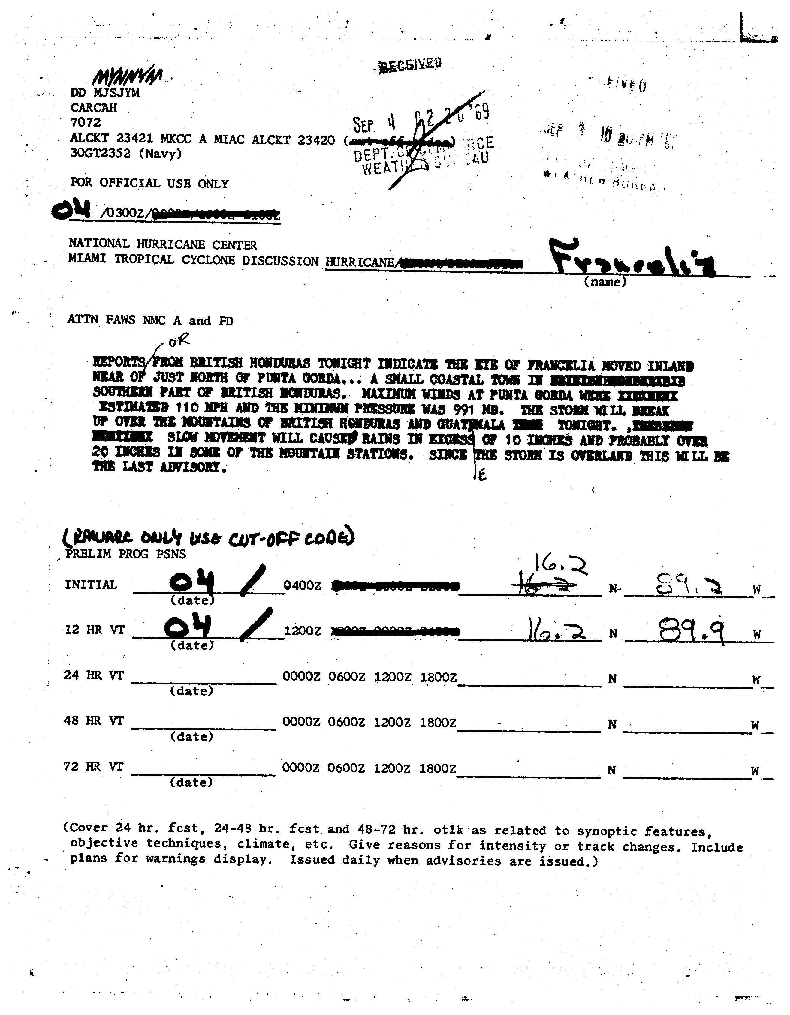
- In 1969, Hurricane Francelia hit southern Belize, then known as British Honduras, weakening quickly over land and dissipating over Guatemala. The system continued slowly across Central America, crossing into the eastern Pacific Ocean three days after it moved ashore. Its remnants eventually redeveloped into Tropical Storm Glenda off the coast of Mexico. [6] [7]
- Tropical Storm Chloe in 1971 made landfall in the Yucat√°n Peninsula and dissipated soon after. Its remnants continued into the Eastern Pacific and developed into Hurricane Lily, which made landfall in southwest Mexico. [8]
- Also in 1971, Tropical Storm Laura made landfall in Belize and dissipated in Guatemala. Its remnants continued into the Eastern Pacific and developed into Tropical Storm Sharon. [9]
- In 1978, Tropical Storm Bess went southward, affecting Mexico. Its remnants crossed into the Pacific Ocean, where it regenerated into Hurricane Iva. [10]
- Later in 1978, Hurricane Cora's remnants crossed over Central America into the Pacific Ocean, where it reintensified, becoming Hurricane Kristy. [10]
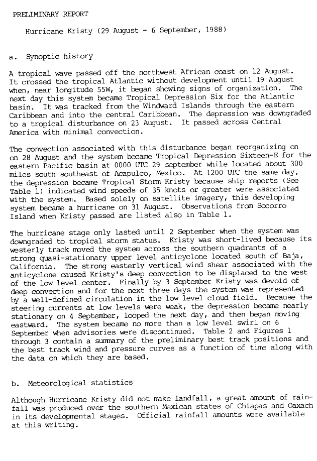
- In 1988, Tropical Depression Six degenerated into a tropical wave near the island of Jamaica on August 23. [11] A day later it moved over Central America with minimal convection and redeveloped into Hurricane Kristy once it reached the eastern Pacific. [12]
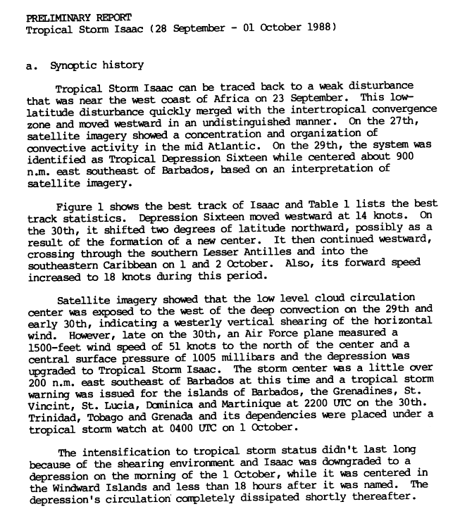
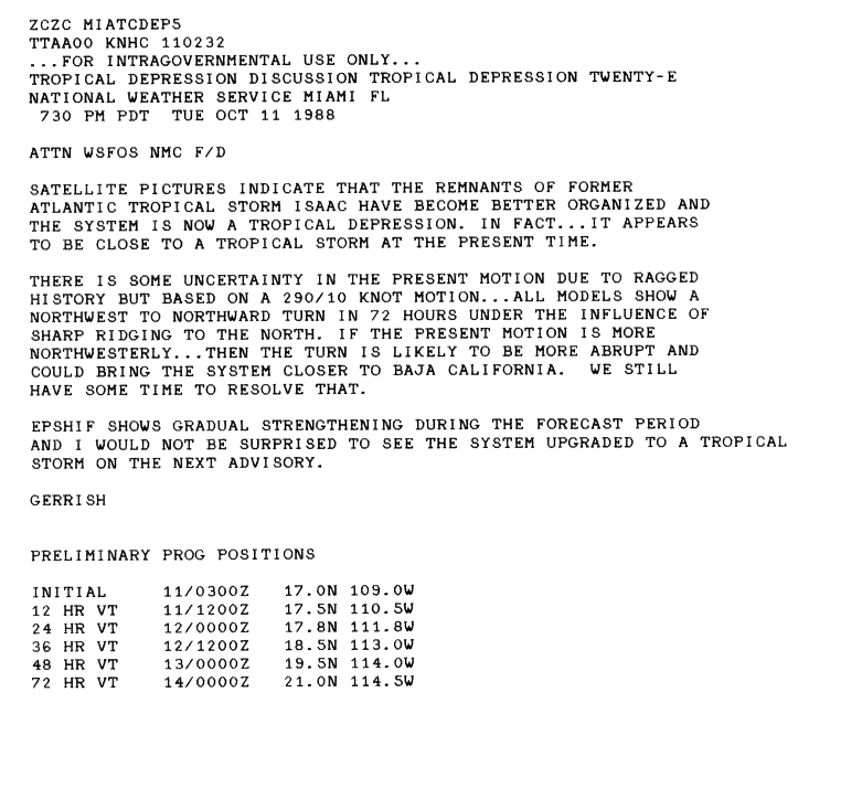
- Later on that same year, Tropical Storm Isaac completely dissipated on October 1 near Windward Islands. [13] Its remnants moved northwestward and crossed into in the eastern Pacific Ocean basin, where it eventually regenerated as Tropical Depression Twenty-E days later. [14]
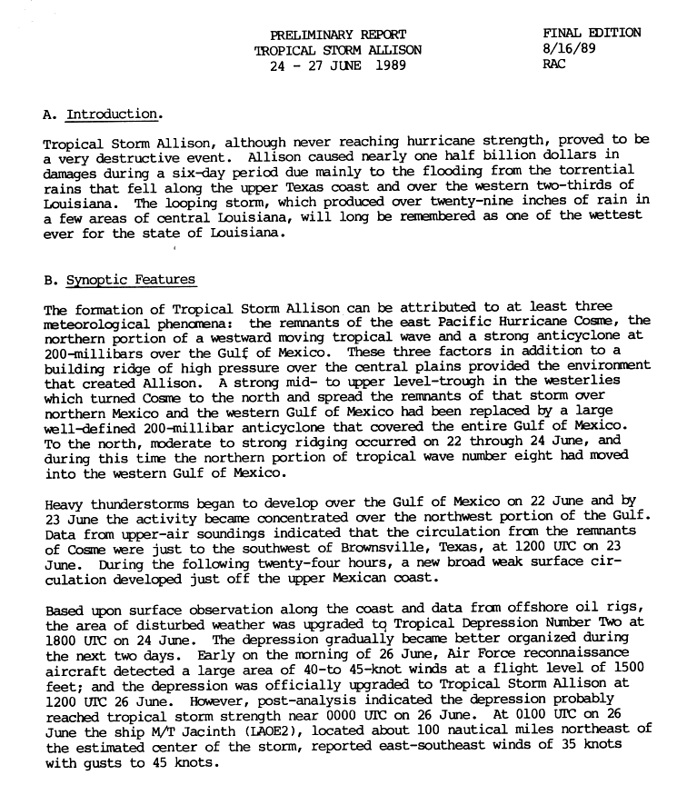
- Hurricane Cosme in 1989 crossed from the Pacific, and its low-level circulation dissipated over northern Mexico. Its remnants merged with another tropical wave and contributed to the development of Tropical Storm Allison in the Atlantic. [15]
- Operationally, it was considered that Tropical Storm Bret, from 1993, retained its circulation and was designated Tropical Depression Eight-E upon reaching the Pacific, later becoming Hurricane Greg, but post-storm analysis determined that Bret actually dissipated over western Nicaragua, with Greg forming from its remnants several days later. [16]
- Tropical Depression Nine in 2001 made landfall in Nicaragua and degenerated into a tropical wave. The wave later regenerated into a tropical depression that became Hurricane Juliette. [17]
- Hurricane Iris's remnants, of 2001, in the Atlantic Ocean triggered the formation of Tropical Storm Manuel in the Pacific. [18]
- Tropical Storm Earl in 2004 dissipated in the southeast Caribbean Sea, but its remnants regenerated into Hurricane Frank in the East Pacific. [19]
- Tropical Storm Alma of 2008 formed off of the West Coast of Costa Rica, and made landfall in Nicaragua with sustained wind speeds up to 100 kilometres per hour (62 mph). The low-level circulation center of the storm soon dissipated. A day later, the storm's remnants regenerated on Nicaragua's east coast into Tropical Storm Arthur, after encountering a pair of two tropical waves, with sustained winds of 75 km/h (47 mph), and again made landfall in Nicaragua. It is not considered as crossover storm, as the original low-level circulation center had dissipated, and since the system also merged with another tropical wave prior to regeneration. [20] [21]
- Hurricane Ernesto of 2012 developed near the Lesser Antilles. The system weakened to a low-pressure area in Mexico, and its remnants moved into the eastern Pacific and developed into Tropical Storm Hector. [22] [23]
- Hurricane Barbara of 2013 made landfall in southwest Mexico and dissipated before reaching the Gulf of Mexico. The remnants of Barbara and a cyclonic gyre led to the formation of a broad area of low pressure, which later became Tropical Storm Andrea over the central Gulf of Mexico. [24]
- Tropical Storm Trudy of 2014 formed in the eastern Pacific and made landfall in southern Mexico, its remnants emerged into the Bay of Campeche and subsequently developed into Tropical Storm Hanna in the Atlantic. [25]
- The remnant moisture from Hurricane Earl of 2016 interacted with a disturbance on the Pacific coast of Mexico, which contributed to the formation of Tropical Storm Javier in the eastern Pacific. [26]
- The remnants of Tropical Storm Bret of 2017 traversed over Central America and emerged into the eastern Pacific, which led to the formation of Hurricane Dora. [27]
- Also in 2017, Hurricane Franklin made landfall in the Mexican state of Veracruz; its remnants moved across Mexico during the following day and emerged into the eastern Pacific, later developing into Tropical Storm Jova. [28]
- Later that year, Hurricane Katia made landfall in Mexico and was then downgraded to a remnant low; its remnants crossed into the Pacific Ocean, where it regenerated into Hurricane Otis. [29]
- Tropical Storm Amanda of 2020 made landfall in southeastern Guatemala, rapidly weakened, and the storm's low-level circulation center dissipated. However, its remnant low-pressure area continued northward and eventually regenerated into Tropical Storm Cristobal in the Bay of Campeche. [30] [31]
- Hurricane Nana of 2020 made landfall in Belize, weakened, and the storm's low-level circulation center dissipated over Guatemala. After its mid-level circulation emerged into the Pacific, contrary to expectations, it developed a new surface low and regenerated into Tropical Storm Julio. [32] [33]
- Hurricane Grace in 2021 made landfall in Mexico as a strong Category 3 hurricane, and the system's low-level circulation center soon dissipated. Its mid-level remnants emerged into the Eastern Pacific and redeveloped into Tropical Storm Marty. [34] [35]
- Hurricane Agatha of 2022 made landfall in Oaxaca then degenerated into a remnant low which dissipated inland, near the northern coast of the Isthmus of Tehuantepec. The remnant low was absorbed into the disorganized disturbance complex that eventually became Tropical Storm Alex. [36]
- Hurricane Julia of 2022, itself a crossover system, made landfall in El Salvador and degraded to a remnant low over Guatemala. Its broad low-level circulation partially contributed to the formation of Tropical Storm Karl over the Gulf of Mexico. [37]
- In 2023, the remnants of Tropical Depression Twenty-One crossed over Central America from the Atlantic and contributed to the formation of Tropical Storm Pilar in the Eastern Pacific. [38]
Naming conventions
Prior to 2000, storms were renamed after crossing from the Atlantic into the Eastern Pacific. At the 22nd hurricane committee in 2000 it was decided that tropical cyclones that moved from the Atlantic to the Eastern Pacific basin and vice versa would no longer be renamed. [39] Hurricane Otto in 2016 was the first storm to cross from one basin to another to apply under this rule.
See also
References
- ^
a
b
"Atlantic hurricane best track (HURDAT version 2)" (Database). United States
National Hurricane Center. April 5, 2023. Retrieved April 18, 2024.
 This article incorporates text from this source, which is in the
public domain.
This article incorporates text from this source, which is in the
public domain.
- ^ Stephen S. Visher (1922). "Tropical Cyclones in the Northeast Pacific, Between Hawaii and Mexico" (PDF). Monthly Weather Review. 50 (6): 295‚Äď97. Bibcode: 1922MWRv...50..295V. doi: 10.1175/1520-0493(1922)50<295:TCITNP>2.0.CO;2. Retrieved 2009-06-12.
- ^ United States Department of Commerce (1955). "Bulletins and Advisories Issued by Weather Bureau Airport Station, San Juan, Puerto Rico, Weather Bureau Office, Miami, Florida, and Weather Bureau Office, New Orleans, Louisiana on Hurricane "Janet"" (PDF). United States Weather Bureau. Retrieved April 28, 2013.
- ^ "The Effects of Tropical Cyclones on the Southwestern United States" (PDF). NOAA Technical Memorandum. National Weather Service Western Region. August 1986. Retrieved July 1, 2013.
- ^ Dunn, Gordon (March 1961). "The Hurricane Season of 1960" (PDF). National Oceanic and Atmospheric Administration. Archived from the original (PDF) on 25 May 2011. Retrieved 29 March 2010.
- ^ National Hurricane Center; Hurricane Research Division; Central Pacific Hurricane Center (2013-04-05). "The Northeast and North Central Pacific hurricane database 1949-2012" (TXT). United States National Oceanic and Atmospheric Administration's National Weather Service. Retrieved 2013-12-23.
- ^ National Hurricane Center (1969-09-04). "Tropical Cyclone Discussion: Hurricane Francelia" (JPG). Retrieved 2010-10-28.
- ^ R. H. Simpson; John R. Hope (April 1972). "Atlantic Hurricane Season of 1971" (PDF). Monthly Weather Review. 100 (4): 256‚Äď267. Bibcode: 1972MWRv..100..256S. doi: 10.1175/1520-0493(1972)100<0256:AHSO>2.3.CO;2. S2CID 119771736. Retrieved 27 January 2007.
- ^ Stephen, Caparotta; Walston, D; Young, Steven; Padgett, Gary; Delgado, Sandy. "What tropical storms and hurricanes have moved from the Atlantic to the Northeast Pacific or vice versa?". NOAA. NOAA. Retrieved March 29, 2016.
- ^ a b Neil L. Frank and Gilbert B. Clark (August 1979). Atlantic Tropical Systems of 1978. National Hurricane Center (Report). Vol. 107. Miami, Florida: National Oceanic and Atmospheric Administration. pp. 1035‚Äď1041. doi: 10.1175/1520-0493(1979)107<1035:ATSO>2.0.CO;2. Retrieved June 3, 2014.
- ^ "August 23, 1988, Tuesday, AM cycle". Domestic News. United Press International. August 23, 1988.
- ^ "Hurricane Kristy Preliminary Report" (GIF). National Hurricane Center. 1988. p. 1. Archived from the original on October 20, 2012. Retrieved November 26, 2007.
- ^ "Tropical Storm Isaac Preliminary Report" (GIF). National Hurricane Center. 1988. p. 1. Archived from the original on October 26, 2007. Retrieved October 21, 2007.
- ^ "Tropical Depression Twenty-E Discussion for 0300 UTC" (GIF). National Hurricane Center. October 11, 1988. Archived from the original on October 26, 2007. Retrieved October 21, 2007.
- ^ Case, Robert (16 August 1989). "Tropical Storm Allison Preliminary Report, Page 1". National Hurricane Center. Retrieved 24 March 2011.
- ^ Pasch, Richard (November 28, 1993). "Hurricane Greg Preliminary Report". National Hurricane Center. Retrieved August 11, 2015.
- ^ Miles B. Lawrence and Michelle M. Mainelli (November 30, 2001). "Hurricane Juliette Tropical Cyclone Report". National Hurricane Center. Archived from the original on October 6, 2008. Retrieved June 28, 2009.
- ^ James L. Franklin (2001-10-31). "Tropical Storm Manuel Tropical Cyclone Report" (PDF). National Hurricane Center. Retrieved 2008-10-20.
- ^ Miles B. Lawrence (August 23, 2004). Tropical Depression Eight-E Discussion Number 1 (Report). National Hurricane Center. Retrieved January 13, 2012.
- ^ Eric Blake (2008). "Tropical Storm Arthur: Tropical Cyclone Report" (PDF). National Hurricane Center. Retrieved 2008-07-29.
- ^ Avila/Rhome (2008). "Tropical Storm Arthur Special Discussion One". National Hurricane Center. Retrieved 2008-05-31.
- ^ Avila, Lixion (August 10, 2012). Tropical Weather Outlook (Report). National Hurricane Center. Retrieved August 10, 2012.
- ^ Lixion Avila (August 11, 2012). "Tropical Depression Eight-E Public Advisory Number 1". National Hurricane Center. Retrieved August 11, 2012.
- ^ John L. Beven II (August 22, 2013). Tropical Cyclone Report: Tropical Storm Andrea (PDF) (Report). Miami, Florida: National Hurricane Center. Retrieved September 7, 2013.
- ^ Daniel P. Brown (December 2, 2014). Tropical Cyclone Report: Tropical Storm Trudy (PDF) (Report). Miami, Florida: National Hurricane Center. Retrieved July 19, 2021.
- ^ Daniel P. Brown (August 2, 2016). "Tropical Weather Outlook". National Hurricane Center. Retrieved August 8, 2016.
- ^ Robbie J. Berg (November 20, 2017). Tropical Cyclone Report: Hurricane Dora (PDF) (Report). Miami, Florida: National Hurricane Center. Retrieved November 22, 2017.
- ^ Eric Blake (August 12, 2017). "Tropical Storm Jova Discussion Number 1". National Hurricane Center. Retrieved August 12, 2017.
- ^ Eric S. Blake (September 5, 2017). Tropical Depression Thirteen Discussion Number 1 (Report). National Hurricane Center. Retrieved February 22, 2018.
- ^ Berg, Robbie (September 10, 2020). Tropical Cyclone Report: Tropical Storm Amanda (PDF) (Report). National Hurricane Center. Retrieved December 27, 2020.
- ^ Berg, Robbie (January 13, 2021). Tropical Cyclone Report: Tropical Storm Cristobal (PDF) (Report). National Hurricane Center. Retrieved January 20, 2021.
- ^ Daniel P. Brown (December 7, 2020). Tropical Cyclone Report: Hurricane Nana (PDF) (Report). National Hurricane Center. Retrieved December 8, 2020.
- ^ Daniel P. Brown (January 21, 2021). Tropical Cyclone Report: Tropical Storm Julio (PDF) (Report). National Hurricane Center. Retrieved March 9, 2021.
- ^ Richard Pasch (August 21, 2021). "Remnants Of Grace Discussion Number 34". National Hurricane Center. Retrieved August 23, 2021.
- ^ Daniel P. Brown (August 23, 2021). "Tropical Storm Marty Discussion Number 1". National Hurricane Center. Retrieved August 23, 2021.
- ^ Beven, John (December 6, 2022). Tropical Cyclone Report: Hurricane Agatha (PDF) (Report). Miami, Florida: National Hurricane Center. Retrieved December 7, 2022.
- ^ Berg, Robbie (January 31, 2023). Tropical Cyclone Report: Tropical Storm Karl (PDF) (Report). Miami, Florida: National Hurricane Center. Retrieved July 20, 2023.
- ^ Bucci, Lisa; Zelensky, Rachel (October 25, 2023). Tropical Weather Outlook (Report). Miami, Florida: National Hurricane Center. Retrieved October 30, 2023.
- ^ RA IV Hurricane Committee (2000). RA IV Hurricane Committee 24th Session (PDF) (Final Report). p. 5. Archived from the original (PDF) on May 19, 2003. Retrieved April 17, 2015.
An Atlantic–Pacific crossover hurricane is a tropical cyclone that develops in the Atlantic Ocean and moves into the Pacific Ocean, or vice versa. Since reliable records began in 1851, a total of twenty-one crossover tropical cyclones have been recorded. As tropical cyclones must travel over land to pass between the Atlantic and Pacific basins, usually their low-level circulation center dissipates and degenerate into remnant lows before completing the crossing. In such instances, they are not considered the same system. [1]
Storms
Official crossovers
| Name | Year | Formation | Dissipation | Peak classification | Mininimum Pressure |
Maximum Winds |
Direction | |
|---|---|---|---|---|---|---|---|---|
| Atlantic | Pacific | |||||||
| Unnamed [2] | 1842 | October | October | Unknown
|
Unknown
|
Unknown | Unknown | Pacific‚Üí Atlantic |
| Unnamed | 1876 | September 29 | October 5 | Category 2 hurricane
|
Tropical storm
|
Unknown | 105 mph (165 km/h) | Atlantic‚Üí Pacific |
| Unnamed | 1902 | October 3 | October 11 | Category 2 hurricane
|
Tropical depression
|
970 mbar (28.64 inHg) | 105 mph (165 km/h) | Pacific‚Üí Atlantic |
| Unnamed | 1911 | September 3 | September 12 | Category 2 hurricane
|
Tropical storm
|
990 mbar (29.23 inHg) | 100 mph (155 km/h) | Atlantic‚Üí Pacific |
| Unnamed | 1923 | October 12 | October 17 | Category 1 hurricane
|
Tropical storm
|
983 mbar (29.03 inHg) | 75 mph (120 km/h) | Pacific‚Üí Atlantic |
| Unnamed | 1945 | October 2 | October 7 | Category 1 hurricane
|
Tropical depression
|
982 mbar (29.00 inHg) | 85 mph (140 km/h) | Atlantic‚Üí Pacific |
| Unnamed | 1949 | September 27 | October 5 | Category 2 hurricane
|
Tropical depression
|
965 mbar (28.50 inHg) | 110 mph (175 km/h) | Pacific‚Üí Atlantic |
| Irene‚ÄďOlivia | 1971 | September 11 | September 30 | Category 1 hurricane
|
Category 3 hurricane
|
948 mbar (27.99 inHg) | 115 mph (185 km/h) | Atlantic‚Üí Pacific |
| Fifi‚ÄďOrlene | 1974 | September 14 | September 24 | Category 2 hurricane
|
Category 2 hurricane
|
971 mbar (28.67 inHg) | 110 mph (175 km/h) | Atlantic‚Üí Pacific |
| Anita | 1977 | August 29 | September 4 | Category 5 hurricane
|
Tropical depression
|
926 mbar (27.34 inHg) | 175 mph (280 km/h) | Atlantic‚Üí Pacific |
| Greta‚ÄďOlivia | 1978 | September 13 | September 23 | Category 4 hurricane
|
Category 1 hurricane
|
947 mbar (27.96 inHg) | 130 mph (215 km/h) | Atlantic‚Üí Pacific |
| Debby | 1988 | August 31 | September 8 | Category 1 hurricane
|
Tropical depression
|
987 mbar (29.15 inHg) | 75 mph (120 km/h) | Atlantic‚Üí Pacific |
| Joan‚ÄďMiriam | 1988 | October 10 | November 2 | Category 4 hurricane
|
Tropical storm
|
932 mbar (27.52 inHg) | 150 mph (240 km/h) | Atlantic‚Üí Pacific |
| Diana | 1990 | August 4 | August 9 | Category 2 hurricane
|
Tropical depression
|
980 mbar (28.94 inHg) | 100 mph (155 km/h) | Atlantic‚Üí Pacific |
| Gert | 1993 | September 14 | September 26 | Category 2 hurricane
|
Tropical depression
|
970 mbar (28.64 inHg) | 105 mph (165 km/h) | Atlantic‚Üí Pacific |
| Cesar‚ÄďDouglas | 1996 | July 24 | August 6 | Category 1 hurricane
|
Category 4 hurricane
|
946 mbar (27.94 inHg) | 130 mph (215 km/h) | Atlantic‚Üí Pacific |
| Dolly | 1996 | August 19 | August 25 | Category 1 hurricane
|
Tropical depression
|
980 mbar (28.94 inHg) | 100 mph (155 km/h) | Atlantic‚Üí Pacific |
| Hermine | 2010 | September 3 | September 9 | Tropical storm
|
Tropical depression
|
989 mbar (29.21 inHg) | 70 mph (110 km/h) | Pacific‚Üí Atlantic |
| Otto | 2016 | November 20 | November 26 | Category 3 hurricane
|
Tropical storm
|
975 mbar (28.79 inHg) | 115 mph (185 km/h) | Atlantic‚Üí Pacific |
| Bonnie | 2022 | July 1 | July 9 | Tropical storm
|
Category 3 hurricane
|
964 mbar (28.47 inHg) | 115 mph (185 km/h) | Atlantic‚Üí Pacific |
| Julia | 2022 | October 7 | October 10 | Category 1 hurricane
|
Tropical storm
|
982 mbar (29.00 inHg) | 85 mph (140 km/h) | Atlantic‚Üí Pacific |
| Note: Information is mostly provided by the Atlantic best track. [1] | ||||||||
Other storms
There have also been numerous tropical cyclones that formed in one basin, dissipated, and re-developed in the other, which are not considered an Atlantic-Pacific crossover hurricane by the NHC. In chronological order from earliest to most recent, they are:
- The remnants of Hurricane Janet in 1955 later led to the formation of an unnamed tropical storm in the East Pacific on October 1; [3] the newly generated tropical cyclone later brought rains to the southwestern United States. [4]
- In 1960, Hurricane Abby made landfall over Belize, then known as British Honduras, and dissipated a day later while situated over the Mexican state of Tabasco. Its remnants crossed over Mexico into the Pacific Ocean and regenerated into Hurricane Celeste on July 20. [5]
- In 1969, Hurricane Francelia hit southern Belize, then known as British Honduras, weakening quickly over land and dissipating over Guatemala. The system continued slowly across Central America, crossing into the eastern Pacific Ocean three days after it moved ashore. Its remnants eventually redeveloped into Tropical Storm Glenda off the coast of Mexico. [6] [7]
- Tropical Storm Chloe in 1971 made landfall in the Yucat√°n Peninsula and dissipated soon after. Its remnants continued into the Eastern Pacific and developed into Hurricane Lily, which made landfall in southwest Mexico. [8]
- Also in 1971, Tropical Storm Laura made landfall in Belize and dissipated in Guatemala. Its remnants continued into the Eastern Pacific and developed into Tropical Storm Sharon. [9]
- In 1978, Tropical Storm Bess went southward, affecting Mexico. Its remnants crossed into the Pacific Ocean, where it regenerated into Hurricane Iva. [10]
- Later in 1978, Hurricane Cora's remnants crossed over Central America into the Pacific Ocean, where it reintensified, becoming Hurricane Kristy. [10]
- In 1988, Tropical Depression Six degenerated into a tropical wave near the island of Jamaica on August 23. [11] A day later it moved over Central America with minimal convection and redeveloped into Hurricane Kristy once it reached the eastern Pacific. [12]
- Later on that same year, Tropical Storm Isaac completely dissipated on October 1 near Windward Islands. [13] Its remnants moved northwestward and crossed into in the eastern Pacific Ocean basin, where it eventually regenerated as Tropical Depression Twenty-E days later. [14]
- Hurricane Cosme in 1989 crossed from the Pacific, and its low-level circulation dissipated over northern Mexico. Its remnants merged with another tropical wave and contributed to the development of Tropical Storm Allison in the Atlantic. [15]
- Operationally, it was considered that Tropical Storm Bret, from 1993, retained its circulation and was designated Tropical Depression Eight-E upon reaching the Pacific, later becoming Hurricane Greg, but post-storm analysis determined that Bret actually dissipated over western Nicaragua, with Greg forming from its remnants several days later. [16]
- Tropical Depression Nine in 2001 made landfall in Nicaragua and degenerated into a tropical wave. The wave later regenerated into a tropical depression that became Hurricane Juliette. [17]
- Hurricane Iris's remnants, of 2001, in the Atlantic Ocean triggered the formation of Tropical Storm Manuel in the Pacific. [18]
- Tropical Storm Earl in 2004 dissipated in the southeast Caribbean Sea, but its remnants regenerated into Hurricane Frank in the East Pacific. [19]
- Tropical Storm Alma of 2008 formed off of the West Coast of Costa Rica, and made landfall in Nicaragua with sustained wind speeds up to 100 kilometres per hour (62 mph). The low-level circulation center of the storm soon dissipated. A day later, the storm's remnants regenerated on Nicaragua's east coast into Tropical Storm Arthur, after encountering a pair of two tropical waves, with sustained winds of 75 km/h (47 mph), and again made landfall in Nicaragua. It is not considered as crossover storm, as the original low-level circulation center had dissipated, and since the system also merged with another tropical wave prior to regeneration. [20] [21]
- Hurricane Ernesto of 2012 developed near the Lesser Antilles. The system weakened to a low-pressure area in Mexico, and its remnants moved into the eastern Pacific and developed into Tropical Storm Hector. [22] [23]
- Hurricane Barbara of 2013 made landfall in southwest Mexico and dissipated before reaching the Gulf of Mexico. The remnants of Barbara and a cyclonic gyre led to the formation of a broad area of low pressure, which later became Tropical Storm Andrea over the central Gulf of Mexico. [24]
- Tropical Storm Trudy of 2014 formed in the eastern Pacific and made landfall in southern Mexico, its remnants emerged into the Bay of Campeche and subsequently developed into Tropical Storm Hanna in the Atlantic. [25]
- The remnant moisture from Hurricane Earl of 2016 interacted with a disturbance on the Pacific coast of Mexico, which contributed to the formation of Tropical Storm Javier in the eastern Pacific. [26]
- The remnants of Tropical Storm Bret of 2017 traversed over Central America and emerged into the eastern Pacific, which led to the formation of Hurricane Dora. [27]
- Also in 2017, Hurricane Franklin made landfall in the Mexican state of Veracruz; its remnants moved across Mexico during the following day and emerged into the eastern Pacific, later developing into Tropical Storm Jova. [28]
- Later that year, Hurricane Katia made landfall in Mexico and was then downgraded to a remnant low; its remnants crossed into the Pacific Ocean, where it regenerated into Hurricane Otis. [29]
- Tropical Storm Amanda of 2020 made landfall in southeastern Guatemala, rapidly weakened, and the storm's low-level circulation center dissipated. However, its remnant low-pressure area continued northward and eventually regenerated into Tropical Storm Cristobal in the Bay of Campeche. [30] [31]
- Hurricane Nana of 2020 made landfall in Belize, weakened, and the storm's low-level circulation center dissipated over Guatemala. After its mid-level circulation emerged into the Pacific, contrary to expectations, it developed a new surface low and regenerated into Tropical Storm Julio. [32] [33]
- Hurricane Grace in 2021 made landfall in Mexico as a strong Category 3 hurricane, and the system's low-level circulation center soon dissipated. Its mid-level remnants emerged into the Eastern Pacific and redeveloped into Tropical Storm Marty. [34] [35]
- Hurricane Agatha of 2022 made landfall in Oaxaca then degenerated into a remnant low which dissipated inland, near the northern coast of the Isthmus of Tehuantepec. The remnant low was absorbed into the disorganized disturbance complex that eventually became Tropical Storm Alex. [36]
- Hurricane Julia of 2022, itself a crossover system, made landfall in El Salvador and degraded to a remnant low over Guatemala. Its broad low-level circulation partially contributed to the formation of Tropical Storm Karl over the Gulf of Mexico. [37]
- In 2023, the remnants of Tropical Depression Twenty-One crossed over Central America from the Atlantic and contributed to the formation of Tropical Storm Pilar in the Eastern Pacific. [38]
Naming conventions
Prior to 2000, storms were renamed after crossing from the Atlantic into the Eastern Pacific. At the 22nd hurricane committee in 2000 it was decided that tropical cyclones that moved from the Atlantic to the Eastern Pacific basin and vice versa would no longer be renamed. [39] Hurricane Otto in 2016 was the first storm to cross from one basin to another to apply under this rule.
See also
References
- ^
a
b
"Atlantic hurricane best track (HURDAT version 2)" (Database). United States
National Hurricane Center. April 5, 2023. Retrieved April 18, 2024. This article incorporates text from this source, which is in the
public domain.
- ^ Stephen S. Visher (1922). "Tropical Cyclones in the Northeast Pacific, Between Hawaii and Mexico" (PDF). Monthly Weather Review. 50 (6): 295‚Äď97. Bibcode: 1922MWRv...50..295V. doi: 10.1175/1520-0493(1922)50<295:TCITNP>2.0.CO;2. Retrieved 2009-06-12.
- ^ United States Department of Commerce (1955). "Bulletins and Advisories Issued by Weather Bureau Airport Station, San Juan, Puerto Rico, Weather Bureau Office, Miami, Florida, and Weather Bureau Office, New Orleans, Louisiana on Hurricane "Janet"" (PDF). United States Weather Bureau. Retrieved April 28, 2013.
- ^ "The Effects of Tropical Cyclones on the Southwestern United States" (PDF). NOAA Technical Memorandum. National Weather Service Western Region. August 1986. Retrieved July 1, 2013.
- ^ Dunn, Gordon (March 1961). "The Hurricane Season of 1960" (PDF). National Oceanic and Atmospheric Administration. Archived from the original (PDF) on 25 May 2011. Retrieved 29 March 2010.
- ^ National Hurricane Center; Hurricane Research Division; Central Pacific Hurricane Center (2013-04-05). "The Northeast and North Central Pacific hurricane database 1949-2012" (TXT). United States National Oceanic and Atmospheric Administration's National Weather Service. Retrieved 2013-12-23.
- ^ National Hurricane Center (1969-09-04). "Tropical Cyclone Discussion: Hurricane Francelia" (JPG). Retrieved 2010-10-28.
- ^ R. H. Simpson; John R. Hope (April 1972). "Atlantic Hurricane Season of 1971" (PDF). Monthly Weather Review. 100 (4): 256‚Äď267. Bibcode: 1972MWRv..100..256S. doi: 10.1175/1520-0493(1972)100<0256:AHSO>2.3.CO;2. S2CID 119771736. Retrieved 27 January 2007.
- ^ Stephen, Caparotta; Walston, D; Young, Steven; Padgett, Gary; Delgado, Sandy. "What tropical storms and hurricanes have moved from the Atlantic to the Northeast Pacific or vice versa?". NOAA. NOAA. Retrieved March 29, 2016.
- ^ a b Neil L. Frank and Gilbert B. Clark (August 1979). Atlantic Tropical Systems of 1978. National Hurricane Center (Report). Vol. 107. Miami, Florida: National Oceanic and Atmospheric Administration. pp. 1035‚Äď1041. doi: 10.1175/1520-0493(1979)107<1035:ATSO>2.0.CO;2. Retrieved June 3, 2014.
- ^ "August 23, 1988, Tuesday, AM cycle". Domestic News. United Press International. August 23, 1988.
- ^ "Hurricane Kristy Preliminary Report" (GIF). National Hurricane Center. 1988. p. 1. Archived from the original on October 20, 2012. Retrieved November 26, 2007.
- ^ "Tropical Storm Isaac Preliminary Report" (GIF). National Hurricane Center. 1988. p. 1. Archived from the original on October 26, 2007. Retrieved October 21, 2007.
- ^ "Tropical Depression Twenty-E Discussion for 0300 UTC" (GIF). National Hurricane Center. October 11, 1988. Archived from the original on October 26, 2007. Retrieved October 21, 2007.
- ^ Case, Robert (16 August 1989). "Tropical Storm Allison Preliminary Report, Page 1". National Hurricane Center. Retrieved 24 March 2011.
- ^ Pasch, Richard (November 28, 1993). "Hurricane Greg Preliminary Report". National Hurricane Center. Retrieved August 11, 2015.
- ^ Miles B. Lawrence and Michelle M. Mainelli (November 30, 2001). "Hurricane Juliette Tropical Cyclone Report". National Hurricane Center. Archived from the original on October 6, 2008. Retrieved June 28, 2009.
- ^ James L. Franklin (2001-10-31). "Tropical Storm Manuel Tropical Cyclone Report" (PDF). National Hurricane Center. Retrieved 2008-10-20.
- ^ Miles B. Lawrence (August 23, 2004). Tropical Depression Eight-E Discussion Number 1 (Report). National Hurricane Center. Retrieved January 13, 2012.
- ^ Eric Blake (2008). "Tropical Storm Arthur: Tropical Cyclone Report" (PDF). National Hurricane Center. Retrieved 2008-07-29.
- ^ Avila/Rhome (2008). "Tropical Storm Arthur Special Discussion One". National Hurricane Center. Retrieved 2008-05-31.
- ^ Avila, Lixion (August 10, 2012). Tropical Weather Outlook (Report). National Hurricane Center. Retrieved August 10, 2012.
- ^ Lixion Avila (August 11, 2012). "Tropical Depression Eight-E Public Advisory Number 1". National Hurricane Center. Retrieved August 11, 2012.
- ^ John L. Beven II (August 22, 2013). Tropical Cyclone Report: Tropical Storm Andrea (PDF) (Report). Miami, Florida: National Hurricane Center. Retrieved September 7, 2013.
- ^ Daniel P. Brown (December 2, 2014). Tropical Cyclone Report: Tropical Storm Trudy (PDF) (Report). Miami, Florida: National Hurricane Center. Retrieved July 19, 2021.
- ^ Daniel P. Brown (August 2, 2016). "Tropical Weather Outlook". National Hurricane Center. Retrieved August 8, 2016.
- ^ Robbie J. Berg (November 20, 2017). Tropical Cyclone Report: Hurricane Dora (PDF) (Report). Miami, Florida: National Hurricane Center. Retrieved November 22, 2017.
- ^ Eric Blake (August 12, 2017). "Tropical Storm Jova Discussion Number 1". National Hurricane Center. Retrieved August 12, 2017.
- ^ Eric S. Blake (September 5, 2017). Tropical Depression Thirteen Discussion Number 1 (Report). National Hurricane Center. Retrieved February 22, 2018.
- ^ Berg, Robbie (September 10, 2020). Tropical Cyclone Report: Tropical Storm Amanda (PDF) (Report). National Hurricane Center. Retrieved December 27, 2020.
- ^ Berg, Robbie (January 13, 2021). Tropical Cyclone Report: Tropical Storm Cristobal (PDF) (Report). National Hurricane Center. Retrieved January 20, 2021.
- ^ Daniel P. Brown (December 7, 2020). Tropical Cyclone Report: Hurricane Nana (PDF) (Report). National Hurricane Center. Retrieved December 8, 2020.
- ^ Daniel P. Brown (January 21, 2021). Tropical Cyclone Report: Tropical Storm Julio (PDF) (Report). National Hurricane Center. Retrieved March 9, 2021.
- ^ Richard Pasch (August 21, 2021). "Remnants Of Grace Discussion Number 34". National Hurricane Center. Retrieved August 23, 2021.
- ^ Daniel P. Brown (August 23, 2021). "Tropical Storm Marty Discussion Number 1". National Hurricane Center. Retrieved August 23, 2021.
- ^ Beven, John (December 6, 2022). Tropical Cyclone Report: Hurricane Agatha (PDF) (Report). Miami, Florida: National Hurricane Center. Retrieved December 7, 2022.
- ^ Berg, Robbie (January 31, 2023). Tropical Cyclone Report: Tropical Storm Karl (PDF) (Report). Miami, Florida: National Hurricane Center. Retrieved July 20, 2023.
- ^ Bucci, Lisa; Zelensky, Rachel (October 25, 2023). Tropical Weather Outlook (Report). Miami, Florida: National Hurricane Center. Retrieved October 30, 2023.
- ^ RA IV Hurricane Committee (2000). RA IV Hurricane Committee 24th Session (PDF) (Final Report). p. 5. Archived from the original (PDF) on May 19, 2003. Retrieved April 17, 2015.