Photos • Location

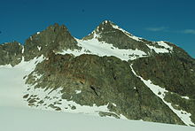
Lisenser Fernerkogel, Rotgratspitze (left) above the Plattige Wand, in June 2012.
| Lisenser Fernerkogel | |
|---|---|
 The Lisenser Fernerkogel from the north (from
Gries im Sellrain) | |
| Highest point | |
| Elevation | 3,298 m (10,820 ft) |
| Prominence | 161 m (528 ft) |
| Coordinates | 47°05′N 11°06′E / 47.083°N 11.100°E |
| Geography | |
| Location | Tyrol, Austria |
| Parent range | Stubai Alps |
| Climbing | |
| First ascent | 23 August 1836 by Peter Karl Thurwieser, Lipp Schöpf and Jackob Kofler[ citation needed] |
| Easiest route | glacier/snow/scramble |
The Lisenser Fernerkogel (or Lüsener Fernerkogel) is a mountain in the Stubai Alps of Austria.
Routes
From the Franz Senn Hütte hut it is approximately 3½ hours mostly over glaciers and snow, with a small (100 m) easy rock scramble at the end.
Close to, and can be combined with, the Rotgratspitze and Lisenser Spitze.
External links

| Lisenser Fernerkogel | |
|---|---|
 The Lisenser Fernerkogel from the north (from
Gries im Sellrain) | |
| Highest point | |
| Elevation | 3,298 m (10,820 ft) |
| Prominence | 161 m (528 ft) |
| Coordinates | 47°05′N 11°06′E / 47.083°N 11.100°E |
| Geography | |
| Location | Tyrol, Austria |
| Parent range | Stubai Alps |
| Climbing | |
| First ascent | 23 August 1836 by Peter Karl Thurwieser, Lipp Schöpf and Jackob Kofler[ citation needed] |
| Easiest route | glacier/snow/scramble |
The Lisenser Fernerkogel (or Lüsener Fernerkogel) is a mountain in the Stubai Alps of Austria.
Routes
From the Franz Senn Hütte hut it is approximately 3½ hours mostly over glaciers and snow, with a small (100 m) easy rock scramble at the end.
Close to, and can be combined with, the Rotgratspitze and Lisenser Spitze.
External links
