Photos • Location
 | |
| General information | |
| Location |
Øvrevoll,
Bærum Norway |
| Coordinates | 59°56′27″N 10°36′59″E / 59.94083°N 10.61639°E |
| Elevation | 123.2 m (404 ft) |
| Owned by | Sporveien |
| Operated by | Sporveien T-banen |
| Line(s) | Røa Line |
| Distance | 9.6 km (6.0 mi) from Stortinget |
| Construction | |
| Structure type | At-grade |
| Accessible | Yes |
| History | |
| Opened | 3 December 1951 |
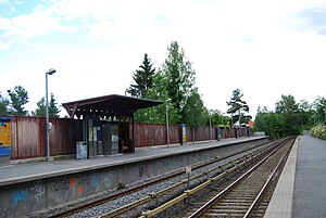
Lijordet is a station on the Røa Line of the Oslo Metro. It is located between Østerås and Eiksmarka, 9.6 km from Stortinget. It is the second of three stations on the Røa Line within Bærum municipality.
The station was opened in 1951 when Røabanen was expanded from Grini to Lijordet.
References
External links
![]() Media related to
Lijordet stasjon at Wikimedia Commons
Media related to
Lijordet stasjon at Wikimedia Commons
| Preceding station |
|
Following station | ||
|---|---|---|---|---|
|
Østerås Terminus
|
Line 2 |
Eiksmarka towards
Ellingsrudåsen
| ||
