Les YvrisâNoisy-le-Grand | |||||||||||
|---|---|---|---|---|---|---|---|---|---|---|---|
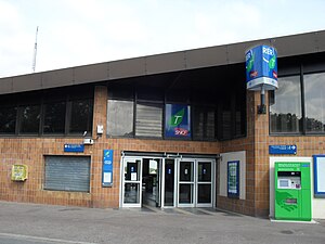
 Station entrance in 2011 | |||||||||||
| General information | |||||||||||
| Location | Avenue du Bois Saint-Martin Noisy-le-Grand France | ||||||||||
| Coordinates | 48°49âČ23âłN 2°34âČ47âłE / 48.823173°N 2.579743°E | ||||||||||
| Owned by | SNCF | ||||||||||
| Operated by | SNCF | ||||||||||
| Line(s) | Paris-EstâMulhouse-Ville railway | ||||||||||
| Platforms | 2 | ||||||||||
| Tracks | 2 | ||||||||||
| Connections |
| ||||||||||
| Construction | |||||||||||
| Accessible | No [1] | ||||||||||
| Other information | |||||||||||
| Station code | 87113803 | ||||||||||
| Fare zone | 4 | ||||||||||
| Passengers | |||||||||||
| 2015 | 831,600 | ||||||||||
| Services | |||||||||||
| |||||||||||
Les YvrisâNoisy-le-Grand is a French railway station located at kilometric point 23.843 of the Paris-EstâMulhouse-Ville railway, on branch E4 of RER E, in Noisy-le-Grand, Seine-Saint-Denis, Ăle-de-France.
The station
Opened on ParisâBĂąle railway, the station is named after a district of Noisy-le-Grand. It has been served since 14 December 2003 by RER E trains bound to Tournan. It was so far served by suburban trains from Paris-Est.
Service
The station is served in both directions by one train every 30 minutes at off-peak times and in the evening, and by 2 to 4 trains an hour during peak hours. More than 45 trains a day serving the station travel towards HaussmannâSaint Lazare, while 44 travel towards Tournan.
Connections
RATP Group bus lines 310, 312 and 320 serve the station.
Traffic
In 2006, around 1 000 people a day entered the station. [2] It is less busy than Noisy-le-GrandâMont d'Est and NoisyâChamps, served by RER A.
Notes and references
- ^ "Plan pour les voyageurs en fauteuil roulant" [Map for travelers in wheelchairs] (PDF). Ăle-de-France MobilitĂ©s (in French and British English). 2023. Retrieved 2023-12-27.
- ^ https://web.archive.org/web/20081125053612/http://www.san-valmaubuee.fr/IMG/pdf/PLD_rapport_ph_1_b3.pdf Plan local de déplacements du Val Maubuée], Juillet 2006, p. 10 du PDF, sur web.archive.org.
External links
- Les YvrisâNoisy-le-Grand station at Transilien, the official website of SNCF (in French)
Les YvrisâNoisy-le-Grand | |||||||||||
|---|---|---|---|---|---|---|---|---|---|---|---|
 Station entrance in 2011 | |||||||||||
| General information | |||||||||||
| Location | Avenue du Bois Saint-Martin Noisy-le-Grand France | ||||||||||
| Coordinates | 48°49âČ23âłN 2°34âČ47âłE / 48.823173°N 2.579743°E | ||||||||||
| Owned by | SNCF | ||||||||||
| Operated by | SNCF | ||||||||||
| Line(s) | Paris-EstâMulhouse-Ville railway | ||||||||||
| Platforms | 2 | ||||||||||
| Tracks | 2 | ||||||||||
| Connections |
| ||||||||||
| Construction | |||||||||||
| Accessible | No [1] | ||||||||||
| Other information | |||||||||||
| Station code | 87113803 | ||||||||||
| Fare zone | 4 | ||||||||||
| Passengers | |||||||||||
| 2015 | 831,600 | ||||||||||
| Services | |||||||||||
| |||||||||||
Les YvrisâNoisy-le-Grand is a French railway station located at kilometric point 23.843 of the Paris-EstâMulhouse-Ville railway, on branch E4 of RER E, in Noisy-le-Grand, Seine-Saint-Denis, Ăle-de-France.
The station
Opened on ParisâBĂąle railway, the station is named after a district of Noisy-le-Grand. It has been served since 14 December 2003 by RER E trains bound to Tournan. It was so far served by suburban trains from Paris-Est.
Service
The station is served in both directions by one train every 30 minutes at off-peak times and in the evening, and by 2 to 4 trains an hour during peak hours. More than 45 trains a day serving the station travel towards HaussmannâSaint Lazare, while 44 travel towards Tournan.
Connections
RATP Group bus lines 310, 312 and 320 serve the station.
Traffic
In 2006, around 1 000 people a day entered the station. [2] It is less busy than Noisy-le-GrandâMont d'Est and NoisyâChamps, served by RER A.
Notes and references
- ^ "Plan pour les voyageurs en fauteuil roulant" [Map for travelers in wheelchairs] (PDF). Ăle-de-France MobilitĂ©s (in French and British English). 2023. Retrieved 2023-12-27.
- ^ https://web.archive.org/web/20081125053612/http://www.san-valmaubuee.fr/IMG/pdf/PLD_rapport_ph_1_b3.pdf Plan local de déplacements du Val Maubuée], Juillet 2006, p. 10 du PDF, sur web.archive.org.
External links
- Les YvrisâNoisy-le-Grand station at Transilien, the official website of SNCF (in French)