Leoville, Kansas | |
|---|---|
 | |
 Leoville  Leoville | |
| Coordinates: 39°34′54″N 100°27′40″W / 39.58167°N 100.46111°W [1] | |
| Country | United States |
| State | Kansas |
| County | Decatur |
| Founded | 1885 |
| Named for | Pope Leo XIII |
| Elevation | 2,753 ft (839 m) |
| Time zone | UTC-6 ( CST) |
| • Summer ( DST) | UTC-5 (CDT) |
| Area code | 785 |
| FIPS code | 20-39600 [1] |
| GNIS ID | 471110 [1] |
Leoville is an unincorporated community in Decatur County, Kansas, United States. [1] Leoville is located along K-223 3.6 miles (5.8 km) south-southwest of Dresden. [2]
History
Leoville was founded in 1885 by a colony of German Catholics. [3] They named their community in honor of Pope Leo XIII. [4]
Education
The community is served by Hoxie USD 412 public school district.
Leoville schools were closed through school unification. The Leoville High School mascot was Leoville Lions. [5]
Notable people
- Roman Catholic Archbishop Stephen Joseph Reichert was born in Leoville. [6]
References
- ^ a b c d e "Leoville, Kansas", Geographic Names Information System, United States Geological Survey, United States Department of the Interior
- ^ 2011-2012 Kansas Official Transportation Map (Map). Kansas Department of Transportation. 2011.
- ^ Federal Writers' Project (1939). Kansas, a Guide to the Sunflower State. Works Progress Administration. p. 448. ISBN 9781623760151.
- ^ "Profile for Leoville, Kansas". ePodunk. Retrieved June 8, 2014.
- ^ "Tigers Trip Leoville", Garden City Telegram, 6 February 1967, p.3.
- ^ Stephen Joseph Reichert
Further reading
External links
Municipalities and communities of
Decatur County, Kansas, United States | ||
|---|---|---|
| Cities | 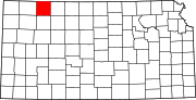 | |
|
Unincorporated communities | ||
| Ghost towns | ||
| Townships | ||
| Footnotes | ‡This community also has portions in an adjacent county or counties. | |
|
| This article about a location in Decatur County, Kansas is a stub. You can help Wikipedia by expanding it. |
Leoville, Kansas | |
|---|---|
|
| |
Leoville Leoville | |
| Coordinates: 39°34′54″N 100°27′40″W / 39.58167°N 100.46111°W [1] | |
| Country | United States |
| State | Kansas |
| County | Decatur |
| Founded | 1885 |
| Named for | Pope Leo XIII |
| Elevation | 2,753 ft (839 m) |
| Time zone | UTC-6 ( CST) |
| • Summer ( DST) | UTC-5 (CDT) |
| Area code | 785 |
| FIPS code | 20-39600 [1] |
| GNIS ID | 471110 [1] |
Leoville is an unincorporated community in Decatur County, Kansas, United States. [1] Leoville is located along K-223 3.6 miles (5.8 km) south-southwest of Dresden. [2]
History
Leoville was founded in 1885 by a colony of German Catholics. [3] They named their community in honor of Pope Leo XIII. [4]
Education
The community is served by Hoxie USD 412 public school district.
Leoville schools were closed through school unification. The Leoville High School mascot was Leoville Lions. [5]
Notable people
- Roman Catholic Archbishop Stephen Joseph Reichert was born in Leoville. [6]
References
- ^ a b c d e "Leoville, Kansas", Geographic Names Information System, United States Geological Survey, United States Department of the Interior
- ^ 2011-2012 Kansas Official Transportation Map (Map). Kansas Department of Transportation. 2011.
- ^ Federal Writers' Project (1939). Kansas, a Guide to the Sunflower State. Works Progress Administration. p. 448. ISBN 9781623760151.
- ^ "Profile for Leoville, Kansas". ePodunk. Retrieved June 8, 2014.
- ^ "Tigers Trip Leoville", Garden City Telegram, 6 February 1967, p.3.
- ^ Stephen Joseph Reichert
Further reading
External links
Municipalities and communities of
Decatur County, Kansas, United States | ||
|---|---|---|
| Cities | | |
|
Unincorporated communities | ||
| Ghost towns | ||
| Townships | ||
| Footnotes | ‡This community also has portions in an adjacent county or counties. | |
|
| This article about a location in Decatur County, Kansas is a stub. You can help Wikipedia by expanding it. |