Lauchhammer | |
|---|---|
 Church of Christ, the King | |
 Coat of arms | |
Location of Lauchhammer within Oberspreewald-Lausitz district  | |
 Lauchhammer  Lauchhammer | |
| Coordinates: 51°30′N 13°48′E / 51.500°N 13.800°E | |
| Country | Germany |
| State | Brandenburg |
| District | Oberspreewald-Lausitz |
| Subdivisions | 5 Stadt- und 2 Ortsteile |
| Government | |
| • Mayor (2021–29) | Mirko Buhr [1] |
| Area | |
| • Total | 88.43 km2 (34.14 sq mi) |
| Highest elevation | 160 m (520 ft) |
| Lowest elevation | 94 m (308 ft) |
| Population (2022-12-31)
[2] | |
| • Total | 14,143 |
| • Density | 160/km2 (410/sq mi) |
| Time zone | UTC+01:00 ( CET) |
| • Summer ( DST) | UTC+02:00 ( CEST) |
| Postal codes | 01979 |
| Dialling codes | 03574 |
| Vehicle registration | OSL |
| Website | www.lauchhammer.de |
Lauchhammer ( Lower Sorbian: Łuchow, pronounced [ˈwuxɔw]) is a town in the Oberspreewald-Lausitz district, in southern Brandenburg, Germany. It is situated on the Black Elster river, approx. 17 km west of Senftenberg, and 50 km north of Dresden.
From 1815 to 1944, Lauchhammer was part of the Prussian Province of Saxony and from 1944 to 1945 of the Province of Halle-Merseburg. From 1947 to 1952 it was part of Saxony-Anhalt and from 1952 to 1990 of the Bezirk Cottbus of East Germany.
-
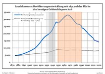 Development of Population since 1875 within the Current Boundaries (Blue Line: Population; Dotted Line: Comparison to Population Development of Brandenburg state; Grey Background: Time of Nazi rule; Red Background: Time of Communist rule)
 -
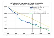 Recent Population Development and Projections (Population Development before Census 2011 (blue line); Recent Population Development according to the Census in Germany in 2011 (blue bordered line); Official projections for 2005-2030 (yellow line); for 2017-2030 (scarlet line); for 2020-2030 (green line)
|
|
|
Lauchhammer lies on the Węgliniec–Roßlau railway and offers connections to Leipzig and Cottbus.
- Sven Benken (born 1970), footballer
- Hans-Joachim Brauske (born 1943), boxer
- Danny Breitfelder (born 1997), footballer
- Thomas Gumpert (1952–2021), actor
- Klaus Haertter (born 1952), fencer
- Stefan Härtel (born 1988), boxer
- Jens Kunath (born 1967), footballer
- Annett Neumann (born 1970), track cyclist
- Magdalena Schmidt (born 1949), gymnast
- Sebastian Schuppan (born 1986), footballer
- Mario Veit (born 1973), boxer
- Annelore Zinke (born 1958), gymnast
- Martin Zurawsky (born 1990), footballer
- ^ Landkreis Oberspreewald-Lausitz Wahl der Bürgermeisterin / des Bürgermeisters, accessed 13 November 2022.
- ^ "Bevölkerungsentwicklung und Bevölkerungsstandim Land Brandenburg Dezember 2022" (PDF). Amt für Statistik Berlin-Brandenburg (in German). June 2023.
- ^ Detailed data sources are to be found in the Wikimedia Commons. Population Projection Brandenburg at Wikimedia Commons
Towns and municipalities in
Oberspreewald-Lausitz | ||
|---|---|---|
 | ||
| International | |
|---|---|
| National | |
| Geographic | |
|
| This Brandenburg location article is a stub. You can help Wikipedia by expanding it. |
Lauchhammer | |
|---|---|
|
Church of Christ, the King | |
|
Coat of arms | |
Location of Lauchhammer within Oberspreewald-Lausitz district | |
Lauchhammer Lauchhammer | |
| Coordinates: 51°30′N 13°48′E / 51.500°N 13.800°E | |
| Country | Germany |
| State | Brandenburg |
| District | Oberspreewald-Lausitz |
| Subdivisions | 5 Stadt- und 2 Ortsteile |
| Government | |
| • Mayor (2021–29) | Mirko Buhr [1] |
| Area | |
| • Total | 88.43 km2 (34.14 sq mi) |
| Highest elevation | 160 m (520 ft) |
| Lowest elevation | 94 m (308 ft) |
| Population (2022-12-31)
[2] | |
| • Total | 14,143 |
| • Density | 160/km2 (410/sq mi) |
| Time zone | UTC+01:00 ( CET) |
| • Summer ( DST) | UTC+02:00 ( CEST) |
| Postal codes | 01979 |
| Dialling codes | 03574 |
| Vehicle registration | OSL |
| Website | www.lauchhammer.de |
Lauchhammer ( Lower Sorbian: Łuchow, pronounced [ˈwuxɔw]) is a town in the Oberspreewald-Lausitz district, in southern Brandenburg, Germany. It is situated on the Black Elster river, approx. 17 km west of Senftenberg, and 50 km north of Dresden.
From 1815 to 1944, Lauchhammer was part of the Prussian Province of Saxony and from 1944 to 1945 of the Province of Halle-Merseburg. From 1947 to 1952 it was part of Saxony-Anhalt and from 1952 to 1990 of the Bezirk Cottbus of East Germany.
-
Development of Population since 1875 within the Current Boundaries (Blue Line: Population; Dotted Line: Comparison to Population Development of Brandenburg state; Grey Background: Time of Nazi rule; Red Background: Time of Communist rule)
-
Recent Population Development and Projections (Population Development before Census 2011 (blue line); Recent Population Development according to the Census in Germany in 2011 (blue bordered line); Official projections for 2005-2030 (yellow line); for 2017-2030 (scarlet line); for 2020-2030 (green line)
|
|
|
Lauchhammer lies on the Węgliniec–Roßlau railway and offers connections to Leipzig and Cottbus.
- Sven Benken (born 1970), footballer
- Hans-Joachim Brauske (born 1943), boxer
- Danny Breitfelder (born 1997), footballer
- Thomas Gumpert (1952–2021), actor
- Klaus Haertter (born 1952), fencer
- Stefan Härtel (born 1988), boxer
- Jens Kunath (born 1967), footballer
- Annett Neumann (born 1970), track cyclist
- Magdalena Schmidt (born 1949), gymnast
- Sebastian Schuppan (born 1986), footballer
- Mario Veit (born 1973), boxer
- Annelore Zinke (born 1958), gymnast
- Martin Zurawsky (born 1990), footballer
- ^ Landkreis Oberspreewald-Lausitz Wahl der Bürgermeisterin / des Bürgermeisters, accessed 13 November 2022.
- ^ "Bevölkerungsentwicklung und Bevölkerungsstandim Land Brandenburg Dezember 2022" (PDF). Amt für Statistik Berlin-Brandenburg (in German). June 2023.
- ^ Detailed data sources are to be found in the Wikimedia Commons. Population Projection Brandenburg at Wikimedia Commons
Towns and municipalities in
Oberspreewald-Lausitz | ||
|---|---|---|
| ||
| International | |
|---|---|
| National | |
| Geographic | |
|
| This Brandenburg location article is a stub. You can help Wikipedia by expanding it. |