Photos • Location
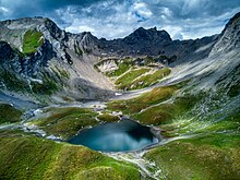
Lac Sans Fond

| Lancebranlette | |
|---|---|
 | |
| Highest point | |
| Elevation | 2,936 m (9,633 ft) |
| Prominence | 147 m (482 ft)
|
| Isolation | 0.99 km (0.62 mi)
|
| Coordinates | 45°41′07″N 06°51′22″E / 45.68528°N 6.85611°E |
| Geography | |
 Lancebranlette Alps | |
| Location |
Savoie,
France Aosta Valley, Italy |
| Parent range | Mont Blanc Massif |

Lancebranlette ( Italian: Lancebranlette) is a mountain of Savoie, France and of Aosta Valley, Italy. It lies in the Mont Blanc Massif range. It has an elevation of 2,936 metres above sea level.
|
| This Savoie geographical article is a stub. You can help Wikipedia by expanding it. |
|
| This Italian location article is a stub. You can help Wikipedia by expanding it. |
| Lancebranlette | |
|---|---|
|
| |
| Highest point | |
| Elevation | 2,936 m (9,633 ft) |
| Prominence | 147 m (482 ft)
|
| Isolation | 0.99 km (0.62 mi)
|
| Coordinates | 45°41′07″N 06°51′22″E / 45.68528°N 6.85611°E |
| Geography | |
Lancebranlette Alps | |
| Location |
Savoie,
France Aosta Valley, Italy |
| Parent range | Mont Blanc Massif |
Lancebranlette ( Italian: Lancebranlette) is a mountain of Savoie, France and of Aosta Valley, Italy. It lies in the Mont Blanc Massif range. It has an elevation of 2,936 metres above sea level.
|
| This Savoie geographical article is a stub. You can help Wikipedia by expanding it. |
|
| This Italian location article is a stub. You can help Wikipedia by expanding it. |