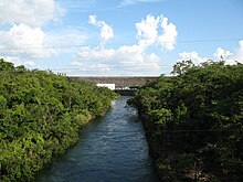
Lam Dom Noi ( Thai: ลำโดมน้อย, pronounced [lām dōːm nɔ́ːj]; Northeastern Thai: ลำโดมน้อย, pronounced [la᷇m dōːm nɔ̂ːj]) is a tributary of the Mun River. It originates in the Dângrêk Mountains and flows northwards. The watercourse passes Buntharik district and is stopped by the Sirindhorn Dam in Chong Mek Subdistrict, Sirindhorn district. It is 150 kilometres (93 mi) long.

The Sirindhorn reservoir is the biggest water resource of Ubon Ratchathani province.
15°17′N 105°28′E / 15.283°N 105.467°E

Lam Dom Noi ( Thai: ลำโดมน้อย, pronounced [lām dōːm nɔ́ːj]; Northeastern Thai: ลำโดมน้อย, pronounced [la᷇m dōːm nɔ̂ːj]) is a tributary of the Mun River. It originates in the Dângrêk Mountains and flows northwards. The watercourse passes Buntharik district and is stopped by the Sirindhorn Dam in Chong Mek Subdistrict, Sirindhorn district. It is 150 kilometres (93 mi) long.

The Sirindhorn reservoir is the biggest water resource of Ubon Ratchathani province.
15°17′N 105°28′E / 15.283°N 105.467°E