Lake Tahoma is a private lake in the mountains of Western
North Carolina, United States, in
McDowell County.[1] It is fed by the waters of Buck Creek, a tributary of the
Catawba River.[2] The lake is about 5 miles northwest of
Marion.
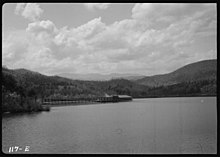
The Casino on Lake TahomaLake Tahoma and Pavilion, Black Mountain in background, 1936
Notes
Wikimedia Commons has media related to Lake Tahoma.
Lake Tahoma is a private lake in the mountains of Western
North Carolina, United States, in
McDowell County.[1] It is fed by the waters of Buck Creek, a tributary of the
Catawba River.[2] The lake is about 5 miles northwest of
Marion.
The Casino on Lake TahomaLake Tahoma and Pavilion, Black Mountain in background, 1936
Notes
Wikimedia Commons has media related to Lake Tahoma.