| Lake Chabot Regional Park | |
|---|---|

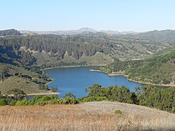
Lake Chabot, from the Fairmont Staging Area, Lake Chabot Regional Park | |
| Location | Alameda County, California |
| Coordinates | 37°44′23″N 122°06′05″W / 37.739769°N 122.101364°W |
| Operated by | East Bay Regional Park District |
Lake Chabot Regional Park is a regional park located in the southern Berkeley Hills in Alameda County, California. It was opened to the public on June 18, 1966, as part of the East Bay Regional Parks system. [1]
Lake Chabot is a reservoir located in the park. [1] The northern part of the lake and park lie within the boundary of the city of Oakland, while the southern part lies in an unincorporated area of Alameda County adjacent to Castro Valley and San Leandro. [2]
The dam and reservoir's water are part of the East Bay Municipal Utility District (EBMUD) water system. [1] The 315-acre lake currently serves as emergency water supply to the East Bay, and swimming is never allowed. [3] [1] However, fishing and boating are popular activities at Lake Chabot throughout the year. [3] [1]
- ^ a b c d e "Lake Chabot Regional Park". East Bay Regional Park District. Retrieved July 20, 2024.
- ^ "Chabot Dam Seismic Upgrade Technical Appendices" (PDF). East Bay Municipal Utility District. December 2013. Retrieved July 21, 2024.
- ^ a b Burke, Annie (March 25, 2019). "Thirty-Two Miles in the East Bay Hills". Bay Nature. Retrieved July 21, 2024.
| Lake Chabot Regional Park | |
|---|---|

Lake Chabot, from the Fairmont Staging Area, Lake Chabot Regional Park | |
| Location | Alameda County, California |
| Coordinates | 37°44′23″N 122°06′05″W / 37.739769°N 122.101364°W |
| Operated by | East Bay Regional Park District |
Lake Chabot Regional Park is a regional park located in the southern Berkeley Hills in Alameda County, California. It was opened to the public on June 18, 1966, as part of the East Bay Regional Parks system. [1]
Lake Chabot is a reservoir located in the park. [1] The northern part of the lake and park lie within the boundary of the city of Oakland, while the southern part lies in an unincorporated area of Alameda County adjacent to Castro Valley and San Leandro. [2]
The dam and reservoir's water are part of the East Bay Municipal Utility District (EBMUD) water system. [1] The 315-acre lake currently serves as emergency water supply to the East Bay, and swimming is never allowed. [3] [1] However, fishing and boating are popular activities at Lake Chabot throughout the year. [3] [1]
- ^ a b c d e "Lake Chabot Regional Park". East Bay Regional Park District. Retrieved July 20, 2024.
- ^ "Chabot Dam Seismic Upgrade Technical Appendices" (PDF). East Bay Municipal Utility District. December 2013. Retrieved July 21, 2024.
- ^ a b Burke, Annie (March 25, 2019). "Thirty-Two Miles in the East Bay Hills". Bay Nature. Retrieved July 21, 2024.


