Photos • Location
Laberg
Laberget | |
|---|---|
Village | |
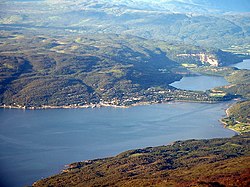
 View of the village (lower right shore) | |
| Coordinates: 68°51′41″N 17°49′11″E / 68.86139°N 17.81972°E | |
| Country | Norway |
| Region | Northern Norway |
| County | Troms |
| District | Hålogaland |
| Municipality | Salangen Municipality |
| Elevation | 32 m (105 ft) |
| Time zone | UTC+01:00 ( CET) |
| • Summer ( DST) | UTC+02:00 ( CEST) |
| Post Code | 9350 Sjøvegan |
Laberg or Laberget is a village in Salangen Municipality in Troms county, Norway. It is located about 3.5 kilometres (2.2 mi) southwest of the administrative centre of Sjøvegan. Laberget is located at the end of the Sagfjorden where the Sagelva river meets the fjord. The population (2001) of the village is 222. [2]
- ^ "Laberget, Salangen" (in Norwegian). yr.no. Retrieved 2012-09-12.
-
^
Statistisk sentralbyrå (2001).
"Folke- og boligtellingen 2001, kommune- og bydelshefter 1923 Salangen" (PDF) (in Norwegian).
{{
cite journal}}
: Cite journal requires|journal=( help)
Laberg
Laberget | |
|---|---|
Village | |
 View of the village (lower right shore) | |
| Coordinates: 68°51′41″N 17°49′11″E / 68.86139°N 17.81972°E | |
| Country | Norway |
| Region | Northern Norway |
| County | Troms |
| District | Hålogaland |
| Municipality | Salangen Municipality |
| Elevation | 32 m (105 ft) |
| Time zone | UTC+01:00 ( CET) |
| • Summer ( DST) | UTC+02:00 ( CEST) |
| Post Code | 9350 Sjøvegan |
Laberg or Laberget is a village in Salangen Municipality in Troms county, Norway. It is located about 3.5 kilometres (2.2 mi) southwest of the administrative centre of Sjøvegan. Laberget is located at the end of the Sagfjorden where the Sagelva river meets the fjord. The population (2001) of the village is 222. [2]
- ^ "Laberget, Salangen" (in Norwegian). yr.no. Retrieved 2012-09-12.
-
^
Statistisk sentralbyrå (2001).
"Folke- og boligtellingen 2001, kommune- og bydelshefter 1923 Salangen" (PDF) (in Norwegian).
{{
cite journal}}
: Cite journal requires|journal=( help)

