Photos • Location
La Tola | |
|---|---|
Municipality and town | |
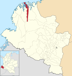
 Location of the municipality and town of La Tola in the Nariño Department of Colombia. | |
| Country | |
| Department | Nariño Department |
| Area | |
| • Total | 128 km2 (49 sq mi) |
| Population (Census 2018
[2]) | |
| • Total | 5,847 |
| • Density | 46/km2 (120/sq mi) |
| Time zone | UTC-5 (Colombia Standard Time) |
La Tola is a town and municipality in the Nariño Department, Colombia.
Climate
La Tola has a tropical rainforest climate ( Köppen Af) with heavy to very heavy rainfall year-round.
| Climate data for La Tola | |||||||||||||
|---|---|---|---|---|---|---|---|---|---|---|---|---|---|
| Month | Jan | Feb | Mar | Apr | May | Jun | Jul | Aug | Sep | Oct | Nov | Dec | Year |
| Mean daily maximum °C (°F) | 28.9 (84.0) |
29.9 (85.8) |
30.3 (86.5) |
30.0 (86.0) |
29.9 (85.8) |
29.9 (85.8) |
29.7 (85.5) |
29.5 (85.1) |
29.2 (84.6) |
28.6 (83.5) |
28.7 (83.7) |
29.1 (84.4) |
29.5 (85.1) |
| Daily mean °C (°F) | 25.6 (78.1) |
26.1 (79.0) |
26.4 (79.5) |
26.3 (79.3) |
26.4 (79.5) |
26.1 (79.0) |
26.0 (78.8) |
25.9 (78.6) |
25.8 (78.4) |
25.7 (78.3) |
25.7 (78.3) |
25.7 (78.3) |
26.0 (78.8) |
| Mean daily minimum °C (°F) | 22.4 (72.3) |
22.3 (72.1) |
22.5 (72.5) |
22.7 (72.9) |
22.9 (73.2) |
22.3 (72.1) |
22.3 (72.1) |
22.4 (72.3) |
22.4 (72.3) |
22.8 (73.0) |
22.7 (72.9) |
22.3 (72.1) |
22.5 (72.5) |
| Average rainfall mm (inches) | 331 (13.0) |
300 (11.8) |
263 (10.4) |
349 (13.7) |
521 (20.5) |
492 (19.4) |
335 (13.2) |
295 (11.6) |
375 (14.8) |
361 (14.2) |
280 (11.0) |
254 (10.0) |
4,156 (163.6) |
| Source: Climate-Data.org [3] | |||||||||||||
References
- ^ "Municipalities of Colombia". statoids. Retrieved 29 April 2020.
- ^ "Censo Nacional de Población y Vivienda 2018" (in Spanish). DANE. Retrieved 29 April 2020.
- ^ "Climate: La Tola". Climate-Data.org. Retrieved October 14, 2020.
2°25′N 78°15′W / 2.417°N 78.250°W
La Tola | |
|---|---|
Municipality and town | |
 Location of the municipality and town of La Tola in the Nariño Department of Colombia. | |
| Country | |
| Department | Nariño Department |
| Area | |
| • Total | 128 km2 (49 sq mi) |
| Population (Census 2018
[2]) | |
| • Total | 5,847 |
| • Density | 46/km2 (120/sq mi) |
| Time zone | UTC-5 (Colombia Standard Time) |
La Tola is a town and municipality in the Nariño Department, Colombia.
Climate
La Tola has a tropical rainforest climate ( Köppen Af) with heavy to very heavy rainfall year-round.
| Climate data for La Tola | |||||||||||||
|---|---|---|---|---|---|---|---|---|---|---|---|---|---|
| Month | Jan | Feb | Mar | Apr | May | Jun | Jul | Aug | Sep | Oct | Nov | Dec | Year |
| Mean daily maximum °C (°F) | 28.9 (84.0) |
29.9 (85.8) |
30.3 (86.5) |
30.0 (86.0) |
29.9 (85.8) |
29.9 (85.8) |
29.7 (85.5) |
29.5 (85.1) |
29.2 (84.6) |
28.6 (83.5) |
28.7 (83.7) |
29.1 (84.4) |
29.5 (85.1) |
| Daily mean °C (°F) | 25.6 (78.1) |
26.1 (79.0) |
26.4 (79.5) |
26.3 (79.3) |
26.4 (79.5) |
26.1 (79.0) |
26.0 (78.8) |
25.9 (78.6) |
25.8 (78.4) |
25.7 (78.3) |
25.7 (78.3) |
25.7 (78.3) |
26.0 (78.8) |
| Mean daily minimum °C (°F) | 22.4 (72.3) |
22.3 (72.1) |
22.5 (72.5) |
22.7 (72.9) |
22.9 (73.2) |
22.3 (72.1) |
22.3 (72.1) |
22.4 (72.3) |
22.4 (72.3) |
22.8 (73.0) |
22.7 (72.9) |
22.3 (72.1) |
22.5 (72.5) |
| Average rainfall mm (inches) | 331 (13.0) |
300 (11.8) |
263 (10.4) |
349 (13.7) |
521 (20.5) |
492 (19.4) |
335 (13.2) |
295 (11.6) |
375 (14.8) |
361 (14.2) |
280 (11.0) |
254 (10.0) |
4,156 (163.6) |
| Source: Climate-Data.org [3] | |||||||||||||
References
- ^ "Municipalities of Colombia". statoids. Retrieved 29 April 2020.
- ^ "Censo Nacional de Población y Vivienda 2018" (in Spanish). DANE. Retrieved 29 April 2020.
- ^ "Climate: La Tola". Climate-Data.org. Retrieved October 14, 2020.
2°25′N 78°15′W / 2.417°N 78.250°W
