 | |
|
| |
| Geography | |
|---|---|
| Location | Manila Bay |
| Coordinates | 14°22′32″N 120°31′19″E / 14.37556°N 120.52194°E |
| Adjacent to | South China Sea |
| Administration | |
| Region | Calabarzon |
| Province | Cavite |
| City | Cavite City |
| Demographics | |
| Population | uninhabited |
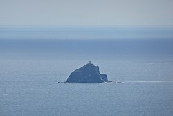
La Monja Island (also Monja Island; Spanish: "the nun") is a small, uninhabited island near the entrance to Manila Bay in the Philippines. Falling under the political jurisdiction of Cavite City, it is located several kilometers southeast of Mariveles, Bataan, and 6.0 kilometers (3.7 mi) west from Corregidor lighthouse. [1] It has remained untouched compared to other nearby islands, which have been used as military installations over the past four centuries.
On May 18, 2012, a pilot and co-pilot were killed when an Aermacchi SF.260 plane belonging to the Philippine Air Force crashed close to the island. [2]
- List of islands in the Greater Manila Area
- List of islands of the Philippines
- List of islands
- Desert island
- ^ Berhow, Mark (20 Sep 2012). American Defenses of Corregidor and Manila Bay: 1898-1945. London: Osprey Publishing. p. 5. ISBN 9781782004356.
- ^ "Debris, human foot found after Philippine military plane crashes". BNO News. May 19, 2012. Retrieved May 19, 2012.