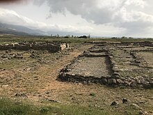
 View of La Hoya | |
| Location | Laguardia, Álava, Basque Country, Spain |
|---|---|
| Coordinates | 42°33′54″N 2°35′11″W / 42.565°N 2.5864°W |
| Type | Settlement |
| Area | 5.1 ha (13 acres) |
| History | |
| Founded | 12th century BCE |
| Abandoned | c. 250 BCE |
| Cultures | Celtiberian |
| Site notes | |
| Discovered | 1935 [1] |
| Archaeologists |
|
| Official name | Recinto Arqueológico de la Hoya [2] |
| Type | Non-movable |
| Criteria | Monument |
| Designated | 17 July 1984 |
| Reference no. | RI-51-0005133 |
La Hoya is an important archaeological site of the Bronze and Iron Ages in Laguardia, Álava, Basque Country, Spain. [3] The fortified town was inhabited between the 12th and 3rd centuries BCE. It has three levels: [4]
- Middle-Late Bronze Age: in this early period, the fortifications, as well the houses, were all made of wood.
- Early-Middle Iron Age: construction became more complex using mixed formulas with stone, wood and adobe. Most houses were near the wall in this period.
- The Late Iron Age, with a cultural context that some classify as Celtiberian, shows important changes in urbanization: with paved streets and plazas that form a reticular structure. The wall is also rebuilt on stone. This final period also shows great advancement in the technologies: potter's wheel, elaborated blacksmithing, etc.
The successive layers of rubble, that served as cementations for further edification, make up a small tell 3 meters high.[ citation needed]
The town was destroyed violently between 350 and 200 BCE, leaving the remains of the people and their everyday items in the streets. [5]
References
- ^ González de Durana, J.M.; Llanos Acebo, H.; Llanos, A.; Ulivarri, V. (1992). "Estudio geofísico preliminar del yacimiento arqueológico de La Hoya, Laguardia (Álava)". Jornadas sobre teledetección y geofísica aplicadas a la arqueología, Madrid 7-10 de mayo de 1986, Mérida 1-3 de octubre de 1987 (PDF) (in Spanish). Instituto de Conservación y Restauración de Bienes Culturales. pp. 99–104. ISBN 84-7483-802-9.
- ^ "Recinto Arqueológico de la Hoya". Consulta a la base de datos de bienes inmuebles (in Spanish). Ministerio de Cultura y Deporte. Retrieved 11 March 2024.
- ^ Arcediano Salazar, Santiago. "Museo de La Hoya". Auñamendi Encyclopedia (in Spanish). Eusko Ikaskuntza. Retrieved 11 March 2024.
- ^ "Poblado de la Hoya". Ondarea (in Spanish). Basque Government. Retrieved 11 March 2024.
- ^ Woodyatt, Amy (30 September 2020). "Archaeologists discover Iron Age massacre, frozen in time". CNN. Retrieved 11 March 2024.
External links
-
 Media related to
La Hoya at Wikimedia Commons
 View of La Hoya | |
| Location | Laguardia, Álava, Basque Country, Spain |
|---|---|
| Coordinates | 42°33′54″N 2°35′11″W / 42.565°N 2.5864°W |
| Type | Settlement |
| Area | 5.1 ha (13 acres) |
| History | |
| Founded | 12th century BCE |
| Abandoned | c. 250 BCE |
| Cultures | Celtiberian |
| Site notes | |
| Discovered | 1935 [1] |
| Archaeologists |
|
| Official name | Recinto Arqueológico de la Hoya [2] |
| Type | Non-movable |
| Criteria | Monument |
| Designated | 17 July 1984 |
| Reference no. | RI-51-0005133 |
La Hoya is an important archaeological site of the Bronze and Iron Ages in Laguardia, Álava, Basque Country, Spain. [3] The fortified town was inhabited between the 12th and 3rd centuries BCE. It has three levels: [4]
- Middle-Late Bronze Age: in this early period, the fortifications, as well the houses, were all made of wood.
- Early-Middle Iron Age: construction became more complex using mixed formulas with stone, wood and adobe. Most houses were near the wall in this period.
- The Late Iron Age, with a cultural context that some classify as Celtiberian, shows important changes in urbanization: with paved streets and plazas that form a reticular structure. The wall is also rebuilt on stone. This final period also shows great advancement in the technologies: potter's wheel, elaborated blacksmithing, etc.
The successive layers of rubble, that served as cementations for further edification, make up a small tell 3 meters high.[ citation needed]
The town was destroyed violently between 350 and 200 BCE, leaving the remains of the people and their everyday items in the streets. [5]
References
- ^ González de Durana, J.M.; Llanos Acebo, H.; Llanos, A.; Ulivarri, V. (1992). "Estudio geofísico preliminar del yacimiento arqueológico de La Hoya, Laguardia (Álava)". Jornadas sobre teledetección y geofísica aplicadas a la arqueología, Madrid 7-10 de mayo de 1986, Mérida 1-3 de octubre de 1987 (PDF) (in Spanish). Instituto de Conservación y Restauración de Bienes Culturales. pp. 99–104. ISBN 84-7483-802-9.
- ^ "Recinto Arqueológico de la Hoya". Consulta a la base de datos de bienes inmuebles (in Spanish). Ministerio de Cultura y Deporte. Retrieved 11 March 2024.
- ^ Arcediano Salazar, Santiago. "Museo de La Hoya". Auñamendi Encyclopedia (in Spanish). Eusko Ikaskuntza. Retrieved 11 March 2024.
- ^ "Poblado de la Hoya". Ondarea (in Spanish). Basque Government. Retrieved 11 March 2024.
- ^ Woodyatt, Amy (30 September 2020). "Archaeologists discover Iron Age massacre, frozen in time". CNN. Retrieved 11 March 2024.
External links
-
 Media related to
La Hoya at Wikimedia Commons

