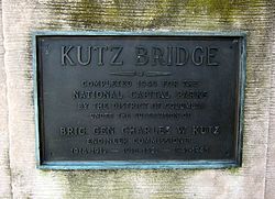
Kutz Memorial Bridge | |
|---|---|
 | |
| Coordinates | 38°53′N 77°02′W / 38.89°N 77.04°W |
| Carries | Independence Avenue |
| Crosses | Tidal Basin |
| Locale | Washington, D.C., United States |
| Named for | Charles W. Kutz |
| History | |
| Architect | Paul Philippe Cret |
| Constructed by | Alexander & Repass Company |
| Construction end | 1943 |
| Location | |
|
| |
The Kutz Memorial Bridge is a bridge that carries Independence Avenue across the Tidal Basin in Washington, D.C., in the United States. Architect Paul Philippe Cret designed the multi-span plate girder bridge in 1941. The Alexander & Repass Company constructed the bridge, which the company completed in 1943. [1]
The bridge's name commemorates Brigadier General Charles Willauer Kutz, who served as Commissioner of Engineering for the District of Columbia during the first half of the 20th century. Following alterations, the bridge was dedicated in 1954. [1]

- ^
a
b (1)
"Memorial". Externalapps.westpointaog.org. Retrieved 31 July 2017.
(2) "List of classified structures: Kutz Memorial Bridge - Res. 332". Hscl.cr.nps.gov. Archived from the original on September 24, 2015. Retrieved October 13, 2015.
(3) "District of Columbia Inventory of Historic Sites" (PDF). District of Columbia Office of Planning - Historic Preservation Office. September 30, 2009. Archived (PDF) from the original on November 5, 2014. Retrieved May 16, 2016.
(4) Bobeczko, Laura L.; Robinson, Judith H., Architectural Historians, Robinson & Associates, Inc. (July 31, 1998). "Kutz Bridge" (PDF). East and West Potomac Park Historic District: Revised National Register of Historic Places Nomination Form: National Register of Historic Places Registration Form (July 16, 1999): Continuation Sheet 7.26. United States Department of the Interior: National Park Service. Archived (PDF) from the original on March 25, 2021.{{ cite web}}: CS1 maint: multiple names: authors list ( link)
-
 Media related to
Kutz Memorial Bridge at Wikimedia Commons
Kutz Memorial Bridge | |
|---|---|
 | |
| Coordinates | 38°53′N 77°02′W / 38.89°N 77.04°W |
| Carries | Independence Avenue |
| Crosses | Tidal Basin |
| Locale | Washington, D.C., United States |
| Named for | Charles W. Kutz |
| History | |
| Architect | Paul Philippe Cret |
| Constructed by | Alexander & Repass Company |
| Construction end | 1943 |
| Location | |
|
| |
The Kutz Memorial Bridge is a bridge that carries Independence Avenue across the Tidal Basin in Washington, D.C., in the United States. Architect Paul Philippe Cret designed the multi-span plate girder bridge in 1941. The Alexander & Repass Company constructed the bridge, which the company completed in 1943. [1]
The bridge's name commemorates Brigadier General Charles Willauer Kutz, who served as Commissioner of Engineering for the District of Columbia during the first half of the 20th century. Following alterations, the bridge was dedicated in 1954. [1]

- ^
a
b (1)
"Memorial". Externalapps.westpointaog.org. Retrieved 31 July 2017.
(2) "List of classified structures: Kutz Memorial Bridge - Res. 332". Hscl.cr.nps.gov. Archived from the original on September 24, 2015. Retrieved October 13, 2015.
(3) "District of Columbia Inventory of Historic Sites" (PDF). District of Columbia Office of Planning - Historic Preservation Office. September 30, 2009. Archived (PDF) from the original on November 5, 2014. Retrieved May 16, 2016.
(4) Bobeczko, Laura L.; Robinson, Judith H., Architectural Historians, Robinson & Associates, Inc. (July 31, 1998). "Kutz Bridge" (PDF). East and West Potomac Park Historic District: Revised National Register of Historic Places Nomination Form: National Register of Historic Places Registration Form (July 16, 1999): Continuation Sheet 7.26. United States Department of the Interior: National Park Service. Archived (PDF) from the original on March 25, 2021.{{ cite web}}: CS1 maint: multiple names: authors list ( link)
-
 Media related to
Kutz Memorial Bridge at Wikimedia Commons