Kuryłówka | |
|---|---|
Village | |
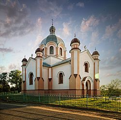
 Saint Nicholas church in Kuryłówka, formerly a
Greek Catholic church built in 1896 | |
| Coordinates: 50°17′50″N 22°27′53″E / 50.29722°N 22.46472°E | |
| Country | |
| Voivodeship | Subcarpathian |
| County | Leżajsk |
| Gmina | Kuryłówka |
| Population | 1,711 [1] |
Kuryłówka [kurɨˈwufka] is a village in Leżajsk County, Subcarpathian Voivodeship, in south-eastern Poland. It is the seat of the gmina (administrative district) called Gmina Kuryłówka. It lies on the navigable San River, approximately 5 kilometres (3 mi) north-east of Leżajsk and 44 km (27 mi) north-east of the regional capital Rzeszów. [2] The village is located in the historical region Galicia. [3]
The village was first mentioned in 1515, although the settlement in this place already existed in Roman times. In 1978, Aleksandra Gruszczyńska from the District Museum in Rzeszów conducted archaeological research during which the remains of a settlement from the Roman period were discovered. June 29, 1944 invasion of Kalmyks. It was the site of anti-communist resistance after World War II (see: Battle of Kurylowka). In 2007 it was damaged by a waterspout.
Transportation
Voivodeship road 877 passes through Kuryłówka.
Notable people
References
- ^ http://www.biuletyn.net/nt-bin/_private/kurylowka/4175.pdf [ bare URL PDF]
- ^ "Central Statistical Office (GUS) - TERYT (National Register of Territorial Land Apportionment Journal)" (in Polish). 2008-06-01.
- ^ http://www.biuletyn.net/nt-bin/_private/kurylowka/4175.pdf/en/gazetteer1900/galizien/lancut [ dead link]
Kuryłówka | |
|---|---|
Village | |
 Saint Nicholas church in Kuryłówka, formerly a
Greek Catholic church built in 1896 | |
| Coordinates: 50°17′50″N 22°27′53″E / 50.29722°N 22.46472°E | |
| Country | |
| Voivodeship | Subcarpathian |
| County | Leżajsk |
| Gmina | Kuryłówka |
| Population | 1,711 [1] |
Kuryłówka [kurɨˈwufka] is a village in Leżajsk County, Subcarpathian Voivodeship, in south-eastern Poland. It is the seat of the gmina (administrative district) called Gmina Kuryłówka. It lies on the navigable San River, approximately 5 kilometres (3 mi) north-east of Leżajsk and 44 km (27 mi) north-east of the regional capital Rzeszów. [2] The village is located in the historical region Galicia. [3]
The village was first mentioned in 1515, although the settlement in this place already existed in Roman times. In 1978, Aleksandra Gruszczyńska from the District Museum in Rzeszów conducted archaeological research during which the remains of a settlement from the Roman period were discovered. June 29, 1944 invasion of Kalmyks. It was the site of anti-communist resistance after World War II (see: Battle of Kurylowka). In 2007 it was damaged by a waterspout.
Transportation
Voivodeship road 877 passes through Kuryłówka.
Notable people
References
- ^ http://www.biuletyn.net/nt-bin/_private/kurylowka/4175.pdf [ bare URL PDF]
- ^ "Central Statistical Office (GUS) - TERYT (National Register of Territorial Land Apportionment Journal)" (in Polish). 2008-06-01.
- ^ http://www.biuletyn.net/nt-bin/_private/kurylowka/4175.pdf/en/gazetteer1900/galizien/lancut [ dead link]
