Photos • Location

Kunhegyes | |
|---|---|
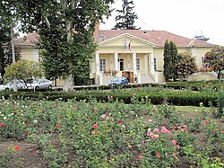
 Town hall | |
| Coordinates: 47°22′13″N 20°37′51″E / 47.37028°N 20.63083°E | |
| Country | |
| County | Jász-Nagykun-Szolnok |
| District | Kunhegyes |
| Area | |
| • Total | 148.94 km2 (57.51 sq mi) |
| Population (2018) | |
| • Total | 7,521 [1] |
| • Density | 57.7/km2 (149/sq mi) |
| Time zone | UTC+1 ( CET) |
| • Summer ( DST) | UTC+2 ( CEST) |
| Postal code | 5340 |
| Area code | (+36) 59 |
| Website |
www |
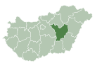
Kunhegyes is a town in northeast Jász-Nagykun-Szolnok, which is situated in Hungary.
Twin towns – sister cities
Kunhegyes is twinned with: [2]
-
 Baia Sprie, Romania (2006)
 -
 Feketić (Mali Iđoš), Serbia (1993)
 -
 Szerzyny, Poland (2006)
References
- ^ KSH, 2018
- ^ "Testvérvárosok". kunhegyes.hu (in Hungarian). Kunhegyes. Retrieved 2021-04-28.
External links
Wikimedia Commons has media related to
Kunhegyes.
- Official website in Hungarian
Kunhegyes | |
|---|---|
 Town hall | |
| Coordinates: 47°22′13″N 20°37′51″E / 47.37028°N 20.63083°E | |
| Country | |
| County | Jász-Nagykun-Szolnok |
| District | Kunhegyes |
| Area | |
| • Total | 148.94 km2 (57.51 sq mi) |
| Population (2018) | |
| • Total | 7,521 [1] |
| • Density | 57.7/km2 (149/sq mi) |
| Time zone | UTC+1 ( CET) |
| • Summer ( DST) | UTC+2 ( CEST) |
| Postal code | 5340 |
| Area code | (+36) 59 |
| Website |
www |
Kunhegyes is a town in northeast Jász-Nagykun-Szolnok, which is situated in Hungary.
Twin towns – sister cities
Kunhegyes is twinned with: [2]
-
 Baia Sprie, Romania (2006)
 -
 Feketić (Mali Iđoš), Serbia (1993)
 -
 Szerzyny, Poland (2006)
References
- ^ KSH, 2018
- ^ "Testvérvárosok". kunhegyes.hu (in Hungarian). Kunhegyes. Retrieved 2021-04-28.
External links
Wikimedia Commons has media related to
Kunhegyes.
- Official website in Hungarian


