Krzemienica | |
|---|---|
Village | |
 View of the village from the west (2024) | |
 Krzemienica | |
| Coordinates: 51°40′35″N 20°12′48″E / 51.67639°N 20.21333°E | |
| Country | |
| Voivodeship | Łódź |
| County | Tomaszów Mazowiecki |
| Gmina | Czerniewice |
| Population (approx.) | 210 |
Krzemienica [kʂɛmjɛˈnit͡sa] is a village in the administrative district of Gmina Czerniewice, within Tomaszów Mazowiecki County, Łódź Voivodeship, in central Poland. It lies approximately 5 kilometres (3 mi) north-east of Czerniewice, 23 km (14 mi) north-east of Tomaszów Mazowiecki, and 53 km (33 mi) east of the regional capital Łódź. [1]
The village has an approximate population of 210.
Gallery
-
The second pond
-
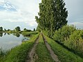 The cuseaway on one of the ponds
 -
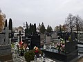 Part of the cemetery in the village
 -
 The structure of the cemetery wall
 -
 One of meadows in the village
 -
 The western part of the village


References

51°40′35″N 20°12′48″E / 51.67639°N 20.21333°E
|
| This Tomaszów Mazowiecki County location article is a stub. You can help Wikipedia by expanding it. |
Krzemienica | |
|---|---|
Village | |
|
View of the village from the west (2024) | |
Krzemienica | |
| Coordinates: 51°40′35″N 20°12′48″E / 51.67639°N 20.21333°E | |
| Country | |
| Voivodeship | Łódź |
| County | Tomaszów Mazowiecki |
| Gmina | Czerniewice |
| Population (approx.) | 210 |
Krzemienica [kʂɛmjɛˈnit͡sa] is a village in the administrative district of Gmina Czerniewice, within Tomaszów Mazowiecki County, Łódź Voivodeship, in central Poland. It lies approximately 5 kilometres (3 mi) north-east of Czerniewice, 23 km (14 mi) north-east of Tomaszów Mazowiecki, and 53 km (33 mi) east of the regional capital Łódź. [1]
The village has an approximate population of 210.
Gallery
-
The second pond
-
The cuseaway on one of the ponds
-
Part of the cemetery in the village
-
The structure of the cemetery wall
-
One of meadows in the village
-
The western part of the village
References
51°40′35″N 20°12′48″E / 51.67639°N 20.21333°E
|
| This Tomaszów Mazowiecki County location article is a stub. You can help Wikipedia by expanding it. |