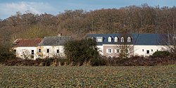
Kréintgeshaff
Kroentgeshof | |
|---|---|
Hamlet | |
 Clear view of Kréintgeshaff | |
| Coordinates: 49.6027909, 6.2308359 | |
| Country | Luxembourg |
| Canton | Luxembourg District |
| Commune | Contern |
| Elevation | 330 m (1,080 ft) |
| Time zone | UTC+1 |
| • Summer ( DST) | UTC+2 |
| Postal Code | 5324 |
| LAU 2 | LU0000302 |

Kréintgeshaff ( Luxembourgish: Kroentgeshof) is a small settlement near Sandweiler in the Commune of Contern in Luxembourg. [1] It is located directly North-East of the Contern-Sandweiler Industrial zone and located adjacent to the E29 Main Road. [2] The settlement is surrounded by small tracks and streams. [3]

The settlement gets no public buses however school Buses running from the Local Ecole Um Ewent Contern run directly to and from Kréintgeshaff every day.
- ^ "Kréintgeshaff farm, Luxembourg, Luxembourg". lu.geoview.info. Retrieved 2021-09-13.
- ^ "Kreintgeshaff · 5330 Contern, Luxembourg". Kreintgeshaff · 5330 Contern, Luxembourg. Retrieved 2021-09-13.
- ^ "Node: Kréintgeshaff (8705448840)". OpenStreetMap. Retrieved 2022-03-01.
49°36′11″N 6°13′52″E / 49.603°N 6.231°E
Kréintgeshaff
Kroentgeshof | |
|---|---|
Hamlet | |
 Clear view of Kréintgeshaff | |
| Coordinates: 49.6027909, 6.2308359 | |
| Country | Luxembourg |
| Canton | Luxembourg District |
| Commune | Contern |
| Elevation | 330 m (1,080 ft) |
| Time zone | UTC+1 |
| • Summer ( DST) | UTC+2 |
| Postal Code | 5324 |
| LAU 2 | LU0000302 |

Kréintgeshaff ( Luxembourgish: Kroentgeshof) is a small settlement near Sandweiler in the Commune of Contern in Luxembourg. [1] It is located directly North-East of the Contern-Sandweiler Industrial zone and located adjacent to the E29 Main Road. [2] The settlement is surrounded by small tracks and streams. [3]

The settlement gets no public buses however school Buses running from the Local Ecole Um Ewent Contern run directly to and from Kréintgeshaff every day.
- ^ "Kréintgeshaff farm, Luxembourg, Luxembourg". lu.geoview.info. Retrieved 2021-09-13.
- ^ "Kreintgeshaff · 5330 Contern, Luxembourg". Kreintgeshaff · 5330 Contern, Luxembourg. Retrieved 2021-09-13.
- ^ "Node: Kréintgeshaff (8705448840)". OpenStreetMap. Retrieved 2022-03-01.
49°36′11″N 6°13′52″E / 49.603°N 6.231°E