Photos • Location
Kollo | |
|---|---|
| Département de Kollo | |
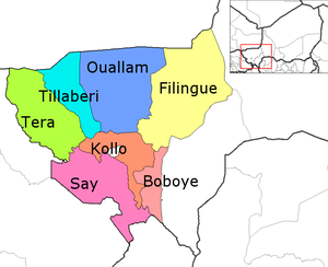
 Kollo Department location in the region | |
| Country |
|
| Region | Tillabéri Region |
| Departmental | Kollo |
| Area | |
| • Total | 10,002 km2 (3,862 sq mi) |
| Population (2012 census) | |
| • Total | 465,399 |
| • Density | 47/km2 (120/sq mi) |
| Time zone | UTC+1 (GMT 1) |
Kollo is a department of the Tillabéri Region in Niger. Its capital lies at the city of Kollo, and includes the towns of N'Dounga, Fakara, Hamdallaye, Karma, Kirtachi, Kouré, Lamordé, Liboré, and Namaro. As of 2012, the department had a total population of 465,399 people. [1] [2]
Communes
References
- ^ "Annuaires_Statistiques" (PDF). Institut National de la Statistique. Retrieved 2 May 2013.
- ^ "Niger: Municipal Division (Departments and Communes) - Population Statistics, Charts and Map". www.citypopulation.de. Retrieved 2024-02-21.
- Portions of this article were translated from the French language Wikipedia article fr:Tillabéri (région), 2008-06-19.
13°18′15″N 2°20′20″E / 13.30417°N 2.33889°E
Kollo | |
|---|---|
| Département de Kollo | |
 Kollo Department location in the region | |
| Country |
|
| Region | Tillabéri Region |
| Departmental | Kollo |
| Area | |
| • Total | 10,002 km2 (3,862 sq mi) |
| Population (2012 census) | |
| • Total | 465,399 |
| • Density | 47/km2 (120/sq mi) |
| Time zone | UTC+1 (GMT 1) |
Kollo is a department of the Tillabéri Region in Niger. Its capital lies at the city of Kollo, and includes the towns of N'Dounga, Fakara, Hamdallaye, Karma, Kirtachi, Kouré, Lamordé, Liboré, and Namaro. As of 2012, the department had a total population of 465,399 people. [1] [2]
Communes
References
- ^ "Annuaires_Statistiques" (PDF). Institut National de la Statistique. Retrieved 2 May 2013.
- ^ "Niger: Municipal Division (Departments and Communes) - Population Statistics, Charts and Map". www.citypopulation.de. Retrieved 2024-02-21.
- Portions of this article were translated from the French language Wikipedia article fr:Tillabéri (région), 2008-06-19.
13°18′15″N 2°20′20″E / 13.30417°N 2.33889°E