Photos • Location

Koila, Estonia | |
|---|---|
Village | |
| Country | |
| County | Harju County |
| Parish | Jõelähtme Parish |
| Time zone | UTC+2 ( EET) |
| • Summer ( DST) | UTC+3 ( EEST) |
Koila is a village in Jõelähtme Parish, Harju County in northern Estonia. [1] It's lies on the left bank of the Jägala River.
Gallery
-
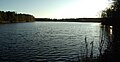 Linnamäe impounded lake on Jägala River.

References
- ^ Classification of Estonian administrative units and settlements 2014[ dead link] (retrieved 27 July 2021)
| Small boroughs |  | |
|---|---|---|
| Villages | ||
59°27′06″N 25°09′50″E / 59.45167°N 25.16389°E
|
| This Harju County location article is a stub. You can help Wikipedia by expanding it. |
Koila, Estonia | |
|---|---|
Village | |
| Country | |
| County | Harju County |
| Parish | Jõelähtme Parish |
| Time zone | UTC+2 ( EET) |
| • Summer ( DST) | UTC+3 ( EEST) |
Koila is a village in Jõelähtme Parish, Harju County in northern Estonia. [1] It's lies on the left bank of the Jägala River.
Gallery
-
Linnamäe impounded lake on Jägala River.
References
- ^ Classification of Estonian administrative units and settlements 2014[ dead link] (retrieved 27 July 2021)
| Small boroughs | | |
|---|---|---|
| Villages | ||
59°27′06″N 25°09′50″E / 59.45167°N 25.16389°E
|
| This Harju County location article is a stub. You can help Wikipedia by expanding it. |