Kirwin | |
|---|---|
.jpg) Kirwin, 1905 | |
 Kirwin Location within the state of Wyoming  Kirwin Kirwin (the United States) | |
| Coordinates: 43°52′35″N 109°17′53″W / 43.87639°N 109.29806°W | |
| Country | United States |
| State | Wyoming |
| County | Park |
| Time zone | UTC-7 ( Mountain (MST)) |
| • Summer ( DST) | UTC-6 (MDT) |
| GNIS feature ID | 1600733 [1] |
Kirwin is a ghost town [2] in Park County, in the U.S. state of Wyoming. Its post office has been closed. [3]
The former mining town is a historic site. Amelia Earhart was having a cabin built there before her disappearance. [4]
History
Kirwin is located at the headwaters of Wood River and is surrounded by several 12,000-foot peaks. [2]
The area's first prospectors, a group of 130 men, arrived in 1870 led by William Kuykendall. [5] The prospectors were made to leave by soldiers from Fort Bowman [6] or possibly Camp Brown [7] due to the area being a part of a treaty with the Shoshone tribe. [5] [6] [7] One of the prospectors, John Henry, was killed after splitting off from the group to hunt buffalo. [5] [6]
It's origins as a town trace back to 1885 when Harry Adams, and the town's namesake, William Kirwin found gold and silver while hunting deer in the area. [2] [6] [7]
The town quickly attracted attention after Adams shared news of the find, sparking a rush of prospectors. [2] In 1891, the Wood River Mining District was formed leading to several claims being made in the surrounding area. [2] [6]
At its peak between 1904 and 1906, the town was home to about 200 people, all miners and their families. [2] [6] [7] "The town was home to a hotel, a boarding house, two general stores, a sawmill, an assay shop, a headquarters building, a post office, and a number of cabins, stables, and meat storage sheds." [2] Many of which buildings are still standing. [2] [4] [6] [7]
On February 5, 1907, the precarious positioning of Kirwin came to a head when a massive avalanche from Bald Mountain struck the town, destroying several buildings and killing three people, causing a large portion of the town to leave the area, with the rest vacating the area in the following years. [2] [7]
There were several attempts at reviving the area, through both the Double D Dude Ranch, as well as various attempts at establishing mining operations in the 40s and 60s, all of which eventually fell through. [6] [7]
In 1992 the land, including Kirwin and the Double D ranch, was purchased by a conservation fund who donated the it to the public, at which point, in 1999 restoration and stabilization of the historic buildings and area began. [2] [6]
Climate
Kirwin has a subarctic climate ( Köppen Dfc).
| Climate data for Kirwin, Wyoming, 1991–2020 normals: 9550ft (2911m) | |||||||||||||
|---|---|---|---|---|---|---|---|---|---|---|---|---|---|
| Month | Jan | Feb | Mar | Apr | May | Jun | Jul | Aug | Sep | Oct | Nov | Dec | Year |
| Mean daily maximum °F (°C) | 26.0 (−3.3) |
27.6 (−2.4) |
36.6 (2.6) |
43.0 (6.1) |
50.7 (10.4) |
59.7 (15.4) |
68.4 (20.2) |
66.7 (19.3) |
56.9 (13.8) |
42.5 (5.8) |
30.8 (−0.7) |
25.0 (−3.9) |
44.5 (6.9) |
| Daily mean °F (°C) | 17.7 (−7.9) |
17.9 (−7.8) |
24.9 (−3.9) |
30.6 (−0.8) |
39.2 (4.0) |
47.3 (8.5) |
54.6 (12.6) |
53.4 (11.9) |
45.3 (7.4) |
33.3 (0.7) |
22.7 (−5.2) |
17.0 (−8.3) |
33.7 (0.9) |
| Mean daily minimum °F (°C) | 9.3 (−12.6) |
7.9 (−13.4) |
12.9 (−10.6) |
18.1 (−7.7) |
27.6 (−2.4) |
34.8 (1.6) |
40.8 (4.9) |
40.0 (4.4) |
33.8 (1.0) |
23.9 (−4.5) |
14.6 (−9.7) |
8.9 (−12.8) |
22.7 (−5.1) |
| Average precipitation inches (mm) | 1.63 (41) |
1.88 (48) |
2.41 (61) |
2.97 (75) |
3.62 (92) |
2.45 (62) |
1.81 (46) |
1.69 (43) |
2.17 (55) |
2.22 (56) |
1.93 (49) |
2.01 (51) |
26.79 (679) |
| Source 1: XMACIS2 [8] | |||||||||||||
| Source 2: NOAA (Precipitation) [9] | |||||||||||||
Mount Crosby (Wyoming) is a mountain that rises to the north of Kirwin. There is no weather station at the summit, but this climate table contains interpolated data for an area around the summit. Mount Crosby has an Alpine climate (ET).
| Climate data for Mount Crosby 43.8749 N, 109.3331 W, Elevation: 11,991 ft (3,655 m) (1991–2020 normals) | |||||||||||||
|---|---|---|---|---|---|---|---|---|---|---|---|---|---|
| Month | Jan | Feb | Mar | Apr | May | Jun | Jul | Aug | Sep | Oct | Nov | Dec | Year |
| Mean daily maximum °F (°C) | 18.8 (−7.3) |
18.7 (−7.4) |
24.8 (−4.0) |
31.0 (−0.6) |
39.7 (4.3) |
49.9 (9.9) |
59.5 (15.3) |
58.4 (14.7) |
49.2 (9.6) |
36.0 (2.2) |
24.4 (−4.2) |
17.9 (−7.8) |
35.7 (2.1) |
| Daily mean °F (°C) | 10.2 (−12.1) |
9.2 (−12.7) |
14.3 (−9.8) |
19.4 (−7.0) |
28.0 (−2.2) |
37.4 (3.0) |
46.0 (7.8) |
45.2 (7.3) |
37.1 (2.8) |
25.7 (−3.5) |
15.8 (−9.0) |
9.6 (−12.4) |
24.8 (−4.0) |
| Mean daily minimum °F (°C) | 1.7 (−16.8) |
−0.3 (−17.9) |
3.7 (−15.7) |
7.9 (−13.4) |
16.4 (−8.7) |
24.8 (−4.0) |
32.6 (0.3) |
32.0 (0.0) |
24.9 (−3.9) |
15.4 (−9.2) |
7.2 (−13.8) |
1.3 (−17.1) |
14.0 (−10.0) |
| Average precipitation inches (mm) | 1.80 (46) |
2.03 (52) |
2.49 (63) |
3.13 (80) |
3.84 (98) |
2.52 (64) |
2.01 (51) |
1.89 (48) |
2.33 (59) |
2.28 (58) |
2.07 (53) |
2.21 (56) |
28.6 (728) |
| Source: PRISM Climate Group [10] | |||||||||||||
Gallery
-
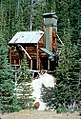 Wolf Mine in Kirwin

References
- ^ U.S. Geological Survey Geographic Names Information System: Kirwin, Wyoming
- ^ a b c d e f g h i j "The History of Kirwin". United States Forest Service. March 7, 2024. Archived from the original on March 7, 2024. Retrieved March 7, 2024.
- ^ U.S. Geological Survey Geographic Names Information System: Kirwin WY post office
- ^ a b Freedman, Lew (July 19, 2017). "Vandalism at Kirwin site investigated". Cody Enterprise. Archived from the original on March 7, 2024. Retrieved August 25, 2017.
- ^
a
b
c Van Pelt, Lori; Van Pelt, Lori (1999). Profiles from Carbon County, Wyoming's past. Dreamers & schemers. Glendo, Wyo: High Plains Press. pp. 164–165.
ISBN
978-0-931271-50-2.
{{
cite book}}
: CS1 maint: date and year ( link) - ^ a b c d e f g h i "Kirwin: Key Dates in History" (PDF). United States Forest Service. Archived (PDF) from the original on March 7, 2024. Retrieved March 7, 2024.
- ^ a b c d e f g Pelt, Lori Van (May 18, 2016). "Kirwin Inspired Dreams of Prosperity, Solitude | WyoHistory.org". www.wyohistory.org. Archived from the original on March 7, 2024. Retrieved March 7, 2024.
- ^ "xmACIS2". National Oceanic and Atmospheric Administration. Retrieved October 12, 2023.
- ^ "Kirwin, Wyoming 1991-2020 Monthly Normals". Retrieved October 12, 2023.
-
^
"PRISM Climate Group, Oregon State University". PRISM Climate Group, Oregon State University. Retrieved October 12, 2023.
To find the table data on the PRISM website, start by clicking Coordinates (under Location); copy Latitude and Longitude figures from top of table; click Zoom to location; click Precipitation, Minimum temp, Mean temp, Maximum temp; click 30-year normals, 1991-2020; click 800m; click Retrieve Time Series button.
Municipalities and communities of
Park County, Wyoming, United States | ||
|---|---|---|
| Cities |  | |
| Towns | ||
| CDPs | ||
|
Unincorporated communities | ||
| Ghost town | ||
| Footnotes | ‡This populated place also has portions in an adjacent county or counties | |
|
| This article about a location in Wyoming is a stub. You can help Wikipedia by expanding it. |
Kirwin | |
|---|---|
|
Kirwin, 1905 | |
Kirwin Location within the state of Wyoming Kirwin Kirwin (the United States) | |
| Coordinates: 43°52′35″N 109°17′53″W / 43.87639°N 109.29806°W | |
| Country | United States |
| State | Wyoming |
| County | Park |
| Time zone | UTC-7 ( Mountain (MST)) |
| • Summer ( DST) | UTC-6 (MDT) |
| GNIS feature ID | 1600733 [1] |
Kirwin is a ghost town [2] in Park County, in the U.S. state of Wyoming. Its post office has been closed. [3]
The former mining town is a historic site. Amelia Earhart was having a cabin built there before her disappearance. [4]
History
Kirwin is located at the headwaters of Wood River and is surrounded by several 12,000-foot peaks. [2]
The area's first prospectors, a group of 130 men, arrived in 1870 led by William Kuykendall. [5] The prospectors were made to leave by soldiers from Fort Bowman [6] or possibly Camp Brown [7] due to the area being a part of a treaty with the Shoshone tribe. [5] [6] [7] One of the prospectors, John Henry, was killed after splitting off from the group to hunt buffalo. [5] [6]
It's origins as a town trace back to 1885 when Harry Adams, and the town's namesake, William Kirwin found gold and silver while hunting deer in the area. [2] [6] [7]
The town quickly attracted attention after Adams shared news of the find, sparking a rush of prospectors. [2] In 1891, the Wood River Mining District was formed leading to several claims being made in the surrounding area. [2] [6]
At its peak between 1904 and 1906, the town was home to about 200 people, all miners and their families. [2] [6] [7] "The town was home to a hotel, a boarding house, two general stores, a sawmill, an assay shop, a headquarters building, a post office, and a number of cabins, stables, and meat storage sheds." [2] Many of which buildings are still standing. [2] [4] [6] [7]
On February 5, 1907, the precarious positioning of Kirwin came to a head when a massive avalanche from Bald Mountain struck the town, destroying several buildings and killing three people, causing a large portion of the town to leave the area, with the rest vacating the area in the following years. [2] [7]
There were several attempts at reviving the area, through both the Double D Dude Ranch, as well as various attempts at establishing mining operations in the 40s and 60s, all of which eventually fell through. [6] [7]
In 1992 the land, including Kirwin and the Double D ranch, was purchased by a conservation fund who donated the it to the public, at which point, in 1999 restoration and stabilization of the historic buildings and area began. [2] [6]
Climate
Kirwin has a subarctic climate ( Köppen Dfc).
| Climate data for Kirwin, Wyoming, 1991–2020 normals: 9550ft (2911m) | |||||||||||||
|---|---|---|---|---|---|---|---|---|---|---|---|---|---|
| Month | Jan | Feb | Mar | Apr | May | Jun | Jul | Aug | Sep | Oct | Nov | Dec | Year |
| Mean daily maximum °F (°C) | 26.0 (−3.3) |
27.6 (−2.4) |
36.6 (2.6) |
43.0 (6.1) |
50.7 (10.4) |
59.7 (15.4) |
68.4 (20.2) |
66.7 (19.3) |
56.9 (13.8) |
42.5 (5.8) |
30.8 (−0.7) |
25.0 (−3.9) |
44.5 (6.9) |
| Daily mean °F (°C) | 17.7 (−7.9) |
17.9 (−7.8) |
24.9 (−3.9) |
30.6 (−0.8) |
39.2 (4.0) |
47.3 (8.5) |
54.6 (12.6) |
53.4 (11.9) |
45.3 (7.4) |
33.3 (0.7) |
22.7 (−5.2) |
17.0 (−8.3) |
33.7 (0.9) |
| Mean daily minimum °F (°C) | 9.3 (−12.6) |
7.9 (−13.4) |
12.9 (−10.6) |
18.1 (−7.7) |
27.6 (−2.4) |
34.8 (1.6) |
40.8 (4.9) |
40.0 (4.4) |
33.8 (1.0) |
23.9 (−4.5) |
14.6 (−9.7) |
8.9 (−12.8) |
22.7 (−5.1) |
| Average precipitation inches (mm) | 1.63 (41) |
1.88 (48) |
2.41 (61) |
2.97 (75) |
3.62 (92) |
2.45 (62) |
1.81 (46) |
1.69 (43) |
2.17 (55) |
2.22 (56) |
1.93 (49) |
2.01 (51) |
26.79 (679) |
| Source 1: XMACIS2 [8] | |||||||||||||
| Source 2: NOAA (Precipitation) [9] | |||||||||||||
Mount Crosby (Wyoming) is a mountain that rises to the north of Kirwin. There is no weather station at the summit, but this climate table contains interpolated data for an area around the summit. Mount Crosby has an Alpine climate (ET).
| Climate data for Mount Crosby 43.8749 N, 109.3331 W, Elevation: 11,991 ft (3,655 m) (1991–2020 normals) | |||||||||||||
|---|---|---|---|---|---|---|---|---|---|---|---|---|---|
| Month | Jan | Feb | Mar | Apr | May | Jun | Jul | Aug | Sep | Oct | Nov | Dec | Year |
| Mean daily maximum °F (°C) | 18.8 (−7.3) |
18.7 (−7.4) |
24.8 (−4.0) |
31.0 (−0.6) |
39.7 (4.3) |
49.9 (9.9) |
59.5 (15.3) |
58.4 (14.7) |
49.2 (9.6) |
36.0 (2.2) |
24.4 (−4.2) |
17.9 (−7.8) |
35.7 (2.1) |
| Daily mean °F (°C) | 10.2 (−12.1) |
9.2 (−12.7) |
14.3 (−9.8) |
19.4 (−7.0) |
28.0 (−2.2) |
37.4 (3.0) |
46.0 (7.8) |
45.2 (7.3) |
37.1 (2.8) |
25.7 (−3.5) |
15.8 (−9.0) |
9.6 (−12.4) |
24.8 (−4.0) |
| Mean daily minimum °F (°C) | 1.7 (−16.8) |
−0.3 (−17.9) |
3.7 (−15.7) |
7.9 (−13.4) |
16.4 (−8.7) |
24.8 (−4.0) |
32.6 (0.3) |
32.0 (0.0) |
24.9 (−3.9) |
15.4 (−9.2) |
7.2 (−13.8) |
1.3 (−17.1) |
14.0 (−10.0) |
| Average precipitation inches (mm) | 1.80 (46) |
2.03 (52) |
2.49 (63) |
3.13 (80) |
3.84 (98) |
2.52 (64) |
2.01 (51) |
1.89 (48) |
2.33 (59) |
2.28 (58) |
2.07 (53) |
2.21 (56) |
28.6 (728) |
| Source: PRISM Climate Group [10] | |||||||||||||
Gallery
-
Wolf Mine in Kirwin
References
- ^ U.S. Geological Survey Geographic Names Information System: Kirwin, Wyoming
- ^ a b c d e f g h i j "The History of Kirwin". United States Forest Service. March 7, 2024. Archived from the original on March 7, 2024. Retrieved March 7, 2024.
- ^ U.S. Geological Survey Geographic Names Information System: Kirwin WY post office
- ^ a b Freedman, Lew (July 19, 2017). "Vandalism at Kirwin site investigated". Cody Enterprise. Archived from the original on March 7, 2024. Retrieved August 25, 2017.
- ^
a
b
c Van Pelt, Lori; Van Pelt, Lori (1999). Profiles from Carbon County, Wyoming's past. Dreamers & schemers. Glendo, Wyo: High Plains Press. pp. 164–165.
ISBN
978-0-931271-50-2.
{{
cite book}}
: CS1 maint: date and year ( link) - ^ a b c d e f g h i "Kirwin: Key Dates in History" (PDF). United States Forest Service. Archived (PDF) from the original on March 7, 2024. Retrieved March 7, 2024.
- ^ a b c d e f g Pelt, Lori Van (May 18, 2016). "Kirwin Inspired Dreams of Prosperity, Solitude | WyoHistory.org". www.wyohistory.org. Archived from the original on March 7, 2024. Retrieved March 7, 2024.
- ^ "xmACIS2". National Oceanic and Atmospheric Administration. Retrieved October 12, 2023.
- ^ "Kirwin, Wyoming 1991-2020 Monthly Normals". Retrieved October 12, 2023.
-
^
"PRISM Climate Group, Oregon State University". PRISM Climate Group, Oregon State University. Retrieved October 12, 2023.
To find the table data on the PRISM website, start by clicking Coordinates (under Location); copy Latitude and Longitude figures from top of table; click Zoom to location; click Precipitation, Minimum temp, Mean temp, Maximum temp; click 30-year normals, 1991-2020; click 800m; click Retrieve Time Series button.
Municipalities and communities of
Park County, Wyoming, United States | ||
|---|---|---|
| Cities | | |
| Towns | ||
| CDPs | ||
|
Unincorporated communities | ||
| Ghost town | ||
| Footnotes | ‡This populated place also has portions in an adjacent county or counties | |
|
| This article about a location in Wyoming is a stub. You can help Wikipedia by expanding it. |