-
 Tile-roofed bridge
 -
 Bell hall of the Phát Diệm Cathedral
 -
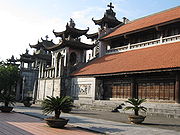 The Cathedral
 -
 An angel carving
Photos • Location


You can help expand this article with text translated from
the corresponding article in Vietnamese. (March 2009) Click [show] for important translation instructions.
|
Kim Sơn district
Huyện Kim Sơn | |
|---|---|
 The front of the Phat Diem Cathedral | |
| Country | |
| Region | Red River Delta |
| Province | Ninh Bình |
| Capital | Phát Diệm |
| Area | |
| • Total | 64 sq mi (165 km2) |
| Population (2003) | |
| • Total | 171,660 |
| Time zone | UTC+7 (Indochina Time) |
Kim Sơn () is a rural district of Ninh Bình province in the Red River Delta region of Vietnam. As of 2003 the district had a population of 171,660. [1] The district covers an area of 165 km². The district capital lies at Phát Diệm. [1]


Wikimedia Commons has media related to
Kim Son District.
- ^ a b "Districts of Vietnam". Statoids. Retrieved March 20, 2009.
- Kim Ân (January 2019). "Quê hương yêu dấu". Archived from the original on 1 February 2019.
|
| This article about a location in Ninh Bình province, Vietnam is a stub. You can help Wikipedia by expanding it. |
20°04′59″N 106°04′59″E / 20.083°N 106.083°E
Districts of the
Red River Delta | ||
|---|---|---|
| Hanoi city |
|  |
| Haiphong city | ||
| Bắc Ninh province | ||
| Hà Nam province | ||
| Hải Dương province |
| |
| Hưng Yên province | ||
| Nam Định province | ||
| Ninh Bình province | ||
| Thái Bình province | ||
| Vĩnh Phúc province |
| |
※ denotes provincial seat. | ||
You can help expand this article with text translated from
the corresponding article in Vietnamese. (March 2009) Click [show] for important translation instructions.
|
Kim Sơn district
Huyện Kim Sơn | |
|---|---|
|
The front of the Phat Diem Cathedral | |
| Country | |
| Region | Red River Delta |
| Province | Ninh Bình |
| Capital | Phát Diệm |
| Area | |
| • Total | 64 sq mi (165 km2) |
| Population (2003) | |
| • Total | 171,660 |
| Time zone | UTC+7 (Indochina Time) |
Kim Sơn () is a rural district of Ninh Bình province in the Red River Delta region of Vietnam. As of 2003 the district had a population of 171,660. [1] The district covers an area of 165 km². The district capital lies at Phát Diệm. [1]
-
Tile-roofed bridge
-
Bell hall of the Phát Diệm Cathedral
-
The Cathedral
-
An angel carving
Wikimedia Commons has media related to
Kim Son District.
- ^ a b "Districts of Vietnam". Statoids. Retrieved March 20, 2009.
- Kim Ân (January 2019). "Quê hương yêu dấu". Archived from the original on 1 February 2019.
|
| This article about a location in Ninh Bình province, Vietnam is a stub. You can help Wikipedia by expanding it. |
20°04′59″N 106°04′59″E / 20.083°N 106.083°E
Districts of the
Red River Delta | ||
|---|---|---|
| Hanoi city |
| |
| Haiphong city | ||
| Bắc Ninh province | ||
| Hà Nam province | ||
| Hải Dương province |
| |
| Hưng Yên province | ||
| Nam Định province | ||
| Ninh Bình province | ||
| Thái Bình province | ||
| Vĩnh Phúc province |
| |
※ denotes provincial seat. | ||