The origin of the place name Cill Flainn is unknown. Two suggestions are commonly circulated. ‘Cill’ in
Irish can mean 'cell' or 'churchyard' so in context might mean 'church of Flainn.' A popularised tale[3][4] is that it was named after a
Roman Catholic hermit monk, Flainn, said to have lived by the River Shannow (which runs through Kilflynn). Crippled and blind, he was visited by the
Virgin Mary, who offered to restore his ailing sight. Flainn declined, asking for the miraculous power to be transferred to others via a local well (now Tobar Flainn, well or spring of Flainn). Some refer to this person as ‘St Flainn,’ but no such person was canonised. There is possible confusion with
St Flannan, originally from
Killaloe in
County Clare.[5][6]
The alternative suggestion is that the name derives from the 'O’Flannan tribe': in August 1931, in the Proceedings of the
Royal Irish Academy, a paper referencing a 15th-century manuscript (itself said to be a copy of a 12th-century document) listing rents in
Clanmaurice presents both 'O Flannayn' and 'Kyllflanyn' as 'Kilflyn' in the
English translation from the original
Latin, a significant error which may be the root of the suggestion.[7] The
cantred (cf. Welsh
cantref or English
hundred) or
rural deanery of Othorna & Oflannan (Irish Uí Thorna & Uí Flannáin) was an
Anglo-Norman sub-division, in this case generally along the historical boundaries of much older kingdoms and regions which were part of West
Munster (Irish Iarmuman or Iar Mbumba), in the realm of the
Ciarraighe, and which later became County Kerry some time between 1222 and 1229.[8]
Different anglicised spellings appeared over the years. In
William Petty's
Down Survey of Ireland (1655-1656) the
parish appears as 'Kilfloinie Parish'.[9]Charles Smith wrote it as 'Kilflin' in 1756,[10] as did William Wilson 30 years later.[11] In Taylor and Skinner's road maps of 1777[12] it is spelt 'Kilftyn', likely a transcription error.
A detail from Taylor and Skinner's book of 1777 showing the road from Tralee to Listowel. Kilflynn ('Kilftyn'), Abbeydorney ('Abbydorney'), Lixnaw and Crotto (seat of the Ponsonby family at the time) are clearly shown.
Samuel Lewis wrote it 'Kilflyn' in 1840[13] and this spelling is extant in places like official
Ordnance Survey Ireland maps or on new road signs (particularly the one on Shanow Bridge near
Abbeydorney). Locally, and in most documentation, it is spelt Kilflynn.
Geography
The village lies in the southern part of the
Listowel or Kerry plain. The rocks underlying the village area are typically
Namuriansandstone and
shale[14] which formed between 326 and 313 million years ago during the
Carboniferous period and cover 27% of County Kerry. The centre of Kilflynn is actually on the edge of this area.
The basic bedrock of North Kerry centred on Kilflynn. The bedrock contours were adapted from the Geological Survey of Ireland 1:1 000 000 scale map, 2003More detailed bedrock, from sheet 162 (Tralee) centred on Kilflynn, from the 1:63 620 scale Geological Survey of Ireland map of 1883, surveyed by Frederick J. Foot; key adapted from original.
The area was subject to
glaciation during the
ice ages. The glacial
meltwater evidence coincides with an area to the south and east of Kilflynn and the N26 road, broadly in line with the edge of the hills facing the north-west. The
ice sheet that covered Ireland split about 19,000 years ago, along a corridor that included the area where Kilflynn lies and going down past
Banna Strand (the sea level was lower then) towards the Atlantic. The main ice sheet retreated northwards, separated from the Kerry-Cork ice cap to the south which disappeared approximately 1000 years later.[16]
Kilflynn centre is currently 59m above
sea-level, but the village
elevation is between 45 and 70m. Its
latitude and
longitude are 52.3505 and -9.6253 respectively (52° 21' 2 N, 9° 37' 31 W). As with most of the West of Ireland, the
weather of the area is strongly affected by the
North Atlantic drift and the prevailing south-westerly winds. Being 10 km inland and well beyond the hills to the south-west, Kilflynn is somewhat sheltered from extremes of wind speed and
precipitation experienced largely in the south and west of County Kerry. The average monthly rainfall (full years from 1981 to 2020) is 98mm, with an average of 20 days per month registering rain (>0.1mm) and 15 wet days per month (>1.0mm), with the wettest months usually between October and January. The average daily maximum temperature is 14 °C and the average daily minimum temperature is 7 °C. Summer and winter temperatures (between 2009 and 2021) are 16 °C and 6 °C respectively.[17][18] For
agriculture and
horticulture, the last
spring air
frost is typically in late March or April, that is to say about five to six weeks later than
coastal areas (on exposed land). This is still favourable compared to areas further inland.[19] The agricultural land surrounding the village is regarded as good and mostly unspoilt.
Surface
spring water was used until the late 1970s for drinking in some surrounding areas. The regional bedrock
aquifers for the purposes of
drinking water are regarded as locally important and moderately productive, used where there was no
water main connection. In the limestone areas to the north, the aquifers are regionally important.[20] The River Shannow, which runs through Kilflynn, emanates from the hills south-west of the N69 from Tooreen to Stacks Mountain
townlands and is a
tributary of the River Brick, which in turn joins the
River Feale, entering the Atlantic south of
Ballybunion. Up until the 1980s, there were
eels and
fish such as
brown trout to be found in the river up at least as far as the Waterfall (where the N69 crosses), with birdlife such as various types of
finch,
dippers and what are locally called 'cranes' (
grey herons, which were caught and eaten historically). Since then, the river life has been affected by
pollution.
Kerry County Council, which expects a modest increase in
population, has made plans for updated local
water treatment, improvements for
pedestrians and
cyclists, and supporting repopulation with associated services, also commenting on Kilflynn as a choice for
commuters [into Tralee and Listowel] while impressing the need to retain its peaceful character.[21]
History until 1900
The first known human presence in Ireland after the last ice age has been determined as c.10,500 years B.C.[22]
When the original
Celts of Ireland actually arrived is unknown, with suggestions having been made of between 100 and 5000 years
B.C. from
linguistic and other evidence.[23] The late
NeolithicBeaker folk introduced their
cultural advances possibly from the
Low Countries or from
Iberia; this resulted in key changes and Irish becoming a unique
Celtic language. Recent evidence shows a huge number of Irish men have the R1b
DNA marker with similarly high percentages also found in other modern Celtic areas on the European Atlantic coast, including the
Basque region.[24] The first known
farmers in Ireland or
Britain landed in Kerry c.4350 B.C. but the incidence of their DNA markers is now very scarce, the R1b marker replacing it c.2500 B.C.[25] This coincides well with the arrival of a dominant Beaker culture, including the introduction of
copper mining and
metallurgy in Kerry.
In 2011,
archaeologists working on the site of the realignment of the N69 Tralee-Listowel road found evidence for early
Bronze Age and
mediaeval activity in the townlands of
Gortclohy and
Cloonnafinneela. The Gortclohy dig provided evidence for tool usage from the Beaker period;
aldercharcoal from the site was
carbon-dated to between 2132 and 1920 B.C. This is the most northerly evidence for the Beaker folk in County Kerry. The first Cloonnafinneela dig provided evidence of early mediaeval
iron-working, with
oak and alder charcoal carbon-dated to between 432 and 595 A.D. and further evidence of pit-
kiln charcoal production 200–300 years later. A second dig at Cloonafinneela gave up evidence of various plants as burnt roofing thatch including
rushes,
cereals, hazel, oak and
willow charcoal, the hazel dated to between 1450 and 1635 A.D.[26]
Kilflynn is in the middle of the area settled in the first century by the
Ciarraighe (also Ciarraigh or Ciarraidh], the
mediaeval tribe (from which the county name Kerry is derived) and claimed descendants of Ciar the son of the mythological queen
Medb of
Connacht and one of her lovers, king
Fergus mac Róich of
Ulster.[27][28]
The parish of Kilflynn ('Kilfloinie') detailed in The Barony of Clanmaurice ('Clan Morris') from William Petty's Down Survey of Ireland, 1656-1658A map of the civil parish of Kilflynn indicating its sixteen townlands.
Prior to this the Velabri[29] around Kerry Head and further south the
Iverni people (or Iernoi from the earlier
Greek) were noted by
Ptolemy to be concentrated in the south-west area of Ireland, speaking the most primitive
Goidelic language similar to
Gaulish (as recorded on
Ogham stones, with examples found close by in Knockbrack and
Tralee, from the 6th Century).[30] The
Érainn, in Irish tradition, may be the name for the same group of people as there are linguistic links.[31]
The Stack family, also of Norman heritage, had their seat at Crotto (later known as Crotta) just north of Kilflynn and also owned surrounding townlands.
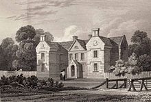
Crotta House, drawn by
John Preston Neale, 1823Crotta House, in 1902, already in disrepair.
Kilflynn had been known as Stackstown, and the name remains geographically in
Stack's Mountains south-east of Kilflynn. The family landowners, namely James (owner of Garrynagore, Gortclohy and Cloghanaleskirt), John (owner of Aghacoora), Richard (owner of Killaspicktarvin (and more northerly townlands)) and Thomas Stack (owner of Gortaneare, Ballyconnell, Castletown, Crotta, Glanballyma, Knocknahila, Cloonnafinneela, and Cappagh)[35] forfeited their landed possessions because of their support for the
Irish Rebellion of 1641 and the subsequent
Catholic Confederation. The reconquest of Ireland between 1649 and 1652 by
Cromwellian forces after the
English Civil War resulted in the
Act for the Settlement of Ireland of 1652 which required a survey for the redistribution of land (hence Sir
William Petty's survey) often to invading soldiers in lieu of wages. Henry Ponsonby, the younger brother of Sir John Ponsonby (a colonel of horse in the
New Model Army), was the recipient of most of the Stacks' (and others') confiscated land - much of which was profitable. This was reconfirmed in 1666, after the
Acts of Settlement.[36][37][38][39] Part of the Down's Survey was Pender's Census, taken between 1654 and 1659. The census refers to 'The Barony of Clanmorice', the townland of 'Crottoe' and the 'Tituladoe' as Henry Ponsonby Esq. The population for the whole of Clanmaurice is given as 1126, of whom 86 are English and 1040 Irish. There are 17 with the surname 'Stack' and 17 with 'FitzMorrice and MacMorrice'.[40][41]
Ponsonby built Crotta House in 1669. The house was sold in 1842 by Thomas Carrique Ponsonby (later resident in
Dublin, so this possibly marked the end of the Ponsonbys in Kerry)[42] and was being leased by about 1850 by Lieutenant Colonel Henry Horatio Kitchener, father to
Horatio Herbert Kitchener, the first Earl Kitchener, Earl of
Khartoum,
Field Marshal of the
British Army and
Minister for War for
Great Britain, who spent most of his youth at Crotta. The mostly derelict remains of the house itself collapsed or were demolished in the 20th century.[43]
The young Horatio Herbert Kitchener on his mother's lap in 1851, with his older brother and sister
From 1840 the
Poor Law Union plans (as basic administrative division) of
Listowel[44] replaced the Norman Clanmaurice barony and civil parish boundaries (although the latter continued to be used to make comparisons) after the act of 1838.[45]
Kilflynn was on the main road from
Tralee to County
Limerick. Farming was the principal industry for centuries and services such as
forges for
smithing, and
lime kilns from the late 1600s (to make lime for acidic soils) developed around this. Local forges were still operational in the mid-20th century. The remains of some kilns can still be found dotted about the landscape. There was a population decline, possibly partly associated with the opening of what is now the main Tralee-Listowel road to the south in 1846, and then the North Kerry railway line with stations opening at Abbeydorney and Lixnaw in 1880 (the line ceasing services entirely from 1978).[46][47] However, there was also from the 1840s onwards the significant effect of the peak years of the
Great Famine in which between 20% and 30% of the population of Kerry died or emigrated (see map).[48] In 1841, 1851 and 1861 the population of Kilflynn village was 147, 134 and 119 respectively[49] (in 2011 it was 126).[50] The area covers two
election districts (Kilflynn and Kilfeighny) so these figures may not be entirely representative.[21]
The Kilflynn
company of the Irish Volunteers was formed in 1913 of about 100 men, drilled by two ex-British
soldiers and
reservists named Collins and Sheehy.[51] On 13 June 1914 a separate
corps formed in Lixnaw,[52] supported on the day by the Kilflynn and other Volunteers. Later in 1914, the reservists were called up to fight in what became
World War I and in addition
John Redmond encouraged the Irish to join the
Allied forces, so the company disbanded as a result and didn't reform until 1917 at Lixnaw. Engagements with the
Royal Irish Constabulary (R.I.C) and the "
Tans" ("
Black and Tans", officially the
R.I.C. Reserve Force) became vehement from 1919 after
Churchill's call to British war
veterans to assist in Ireland. In March 1921 British forces created a cordon starting from Kilflynn to the
Atlantic coast in an attempt to trap and round up
IRA members: hundreds of men were imprisoned in
Ballyheigue Castle, including just one IRA man.
After two previous failures, the IRA succeeded in blowing up the bridge over the Shannow where the road to Kilflynn joins the Abbeydorney-Lixnaw road (R557). Units from Kilflynn and
Abbeydorney lay in wait for
Crown forces and opened fire. There were injuries on both sides and a British officer was killed attempting to cross the river.[53]
Kilflynn IRA
Flying Column, 1922.Back (L to R): Denis O'Connell (Lixnaw),
Stephen Fuller (Kilflynn), William Hartnett (Mountcoal), Tim Twomey (Kilflynn).Front (L to R): Terry Brosnan (Lixnaw), John McElligott (Leam, Kilflynn), Danny O'Shea (Kilflynn), Timothy (Aero) Lyons (Garrynagore), Tim Sheehy (Lyre), Pete Sullivan (Ballyduff), Paddy Mahony (Ballyegan, Battalion O.C.).
Kilflynn
IRA members in the Civil War (‘
Irregulars’) included John McElligott, Danny O’Shea, George O’Shea,
Stephen Fuller and Tim Twomey. The latter three were blown up by
Free State soldiers using a
landmine at
Ballyseedy Cross, near
Tralee, along with six other Irregulars. Fuller, the only survivor of the explosion, was blown clear and escaped the subsequent
coup-de-grâce shooting and bombing. A fabricated explanation of the event, blaming Irregulars for the mine, was given official approval.[54][55] An investigation by Free State Lieutenant
Niall Harrington referred to the report as "totally untrue." The killings came to represent a defining event in modern Irish history.
In recent decades, especially in the surrounding farmland, migration of youth for better financial prospects has kept a smaller, ageing population present, as is typically reflected elsewhere in rural villages of Ireland.[56] However, a number of new houses have been built and the local school, Scoil Treasa Naofa (St.Teresa's
National School)[57] (first sited at Castletown in 1821, just north of the village), has had increased admissions.[21]
Kilflynn has two pubs, a fast food restaurant and a beauty parlour. The Catholic Church is St.Mary's[58] and there is also the 18th century Kilflynn
Church of Ireland which is used as
St.Columba’s Heritage Centre and Museum; these buildings are Recorded Protected Structures.[59] The latter contains the life story of the major local historical figure of note,
Horatio Herbert Kitchener, Earl of Khartoum, the former British Field Marshal and Secretary of State for War, who was born in
Ballylongford and spent most of his youth at nearby Crotta House. A few outbuildings are all that remain of the original estate.[43]
Kilflynn and Abbeydorney are the two villages in which church services are held in the modern Roman Catholic parish of Abbeydorney,[60] whose priest is Fr. Jerry Keane.[61] The parish is in the deanery of St.Brendan's and is one of 53 in the
diocese of Kerry, whose bishop is The Most Reverend
Raymond Anthony Browne.
A view of the main road through the village, looking north, August 2022.
Scoil Treasa Naofa (St.Teresa's National School), townland of Castletown.
St. Columba's heritage centre, formerly a protestant church erected c.1810-11 on the site of a ruinous former church. A belltower was added in 1840. Restoration was completed in 1993. The graveyard contains protestant and catholic burials.
The interior of St. Columba's heritage centre, an active village hall containing accounts of the local history around the walls.
The Republican plot at St. Columba's, grave of George O'Shea, Timothy Tuomey and Timothy Lyons, the former two of Kilflynn killed in the Ballyseedy massacre, the latter of Garrynagore killed at Clashmealcon caves.
The grave at St. Columba's of Stephen Fuller, sole survivor of the Ballyseedy massacre and later a T.D. for Fianna Fáil.
St. Mary's Roman Catholic church. Dated 1849, it was extended in 1935 and renovated in 1979.
A gate lodge at the northern edge of the old Crotta estate, built c.1850. This is the only extant whole structure of the estate. Crotta House was finally demolished in the 20th century.
The shrine constructed around Tobar Flainn - the holy well of St.Flainn - by Muintir na Tíre in 1953. The issue was formerly from some stones near the Rae, a tributary by the well that joins the Shannow.
Panorama made from the road between Kilflynn village and the N69, looking across the Listowel plain from the townland of Glanballyma.
Part of the waterfall of the River Shannow between the townlands of Gortclohy and Glanballyma. The vertical drop of the whole falls is about 20 metres.
^"Kerry". LibraryIreland.com. Retrieved 1 June 2015.
^Ó Cléirigh, Mícheál; Ó Cléirigh, Cú Choigcríche; Ó Maol Chonaire, Fearfeasa; Ó Duibhgeannáin, Peregrine (1636).
Annála Ríoghachta Éireann (The Annals of the Kingdom of Ireland) (2nd, 1856 translation ed.). Dublin: Hodges, Smith & Co. p. 177. Retrieved 1 June 2015.
^Moore, Thomas (1845). The History of Ireland; Commencing with its Earliest Period, to the Expedition Against Scotland in 1545. Philadelphia: Lea & Blanchard. p. 3.
^O'Rahilly, T.F. (1946). "On the Origin of the Names Érainn and Ériu". Ériu. 14. Royal Irish Academy: 7–28.
JSTOR30007646.
^Ó Cléirigh, Mícheál; Ó Cléirigh, Cú Choigcríche; Ó Maol Chonaire, Fearfeasa; Ó Duibhgeannáin, Peregrine (1636).
Annála Ríoghachta Éireann (The Annals of the Kingdom of Ireland) (2nd, 1856 translation ed.). Dublin: Hodges, Smith & Co. p. 178. Retrieved 1 June 2015.
^Curtis, Edmund (1923). (A History of Medieval Ireland: from 1086 to 1513. Oxford: Routledge. pp. 119, 125.
ISBN978-0-4155-2596-1.
^Census of Ireland 1881.
"Census of Ireland for the Year 1881". DIPPAM: Documenting Ireland: Parliament, People and Migration. EPPI. Retrieved 23 July 2015.{{
cite web}}: CS1 maint: numeric names: authors list (
link)
^Lee, J.J. (2009). Kerry's fighting story, 1916-21, told by the men who made it ([New ed.]. ed.). Cork: Mercier Press. p. 79.
ISBN978-1856356411.
^Lee, J.J. (2009). Kerry's fighting story, 1916-21, told by the men who made it ([New ed.]. ed.). Cork: Mercier Press. pp. 291, 292.
ISBN978-1856356411.
^Harrington, Niall C.
"Niall C. Harrington Papers"(PDF). National Library of Ireland (Leabharlain Náisiúnta na hÉirean)n. Retrieved 1 June 2015.
^Office of the Houses of the Oireachtas.
"Dáil Éireann Members' Directory". Tithe an Oireachtas (Houses of the Oireachtas). Retrieved 15 February 2020.
The origin of the place name Cill Flainn is unknown. Two suggestions are commonly circulated. ‘Cill’ in
Irish can mean 'cell' or 'churchyard' so in context might mean 'church of Flainn.' A popularised tale[3][4] is that it was named after a
Roman Catholic hermit monk, Flainn, said to have lived by the River Shannow (which runs through Kilflynn). Crippled and blind, he was visited by the
Virgin Mary, who offered to restore his ailing sight. Flainn declined, asking for the miraculous power to be transferred to others via a local well (now Tobar Flainn, well or spring of Flainn). Some refer to this person as ‘St Flainn,’ but no such person was canonised. There is possible confusion with
St Flannan, originally from
Killaloe in
County Clare.[5][6]
The alternative suggestion is that the name derives from the 'O’Flannan tribe': in August 1931, in the Proceedings of the
Royal Irish Academy, a paper referencing a 15th-century manuscript (itself said to be a copy of a 12th-century document) listing rents in
Clanmaurice presents both 'O Flannayn' and 'Kyllflanyn' as 'Kilflyn' in the
English translation from the original
Latin, a significant error which may be the root of the suggestion.[7] The
cantred (cf. Welsh
cantref or English
hundred) or
rural deanery of Othorna & Oflannan (Irish Uí Thorna & Uí Flannáin) was an
Anglo-Norman sub-division, in this case generally along the historical boundaries of much older kingdoms and regions which were part of West
Munster (Irish Iarmuman or Iar Mbumba), in the realm of the
Ciarraighe, and which later became County Kerry some time between 1222 and 1229.[8]
Different anglicised spellings appeared over the years. In
William Petty's
Down Survey of Ireland (1655-1656) the
parish appears as 'Kilfloinie Parish'.[9]Charles Smith wrote it as 'Kilflin' in 1756,[10] as did William Wilson 30 years later.[11] In Taylor and Skinner's road maps of 1777[12] it is spelt 'Kilftyn', likely a transcription error.
A detail from Taylor and Skinner's book of 1777 showing the road from Tralee to Listowel. Kilflynn ('Kilftyn'), Abbeydorney ('Abbydorney'), Lixnaw and Crotto (seat of the Ponsonby family at the time) are clearly shown.
Samuel Lewis wrote it 'Kilflyn' in 1840[13] and this spelling is extant in places like official
Ordnance Survey Ireland maps or on new road signs (particularly the one on Shanow Bridge near
Abbeydorney). Locally, and in most documentation, it is spelt Kilflynn.
Geography
The village lies in the southern part of the
Listowel or Kerry plain. The rocks underlying the village area are typically
Namuriansandstone and
shale[14] which formed between 326 and 313 million years ago during the
Carboniferous period and cover 27% of County Kerry. The centre of Kilflynn is actually on the edge of this area.
The basic bedrock of North Kerry centred on Kilflynn. The bedrock contours were adapted from the Geological Survey of Ireland 1:1 000 000 scale map, 2003More detailed bedrock, from sheet 162 (Tralee) centred on Kilflynn, from the 1:63 620 scale Geological Survey of Ireland map of 1883, surveyed by Frederick J. Foot; key adapted from original.
The area was subject to
glaciation during the
ice ages. The glacial
meltwater evidence coincides with an area to the south and east of Kilflynn and the N26 road, broadly in line with the edge of the hills facing the north-west. The
ice sheet that covered Ireland split about 19,000 years ago, along a corridor that included the area where Kilflynn lies and going down past
Banna Strand (the sea level was lower then) towards the Atlantic. The main ice sheet retreated northwards, separated from the Kerry-Cork ice cap to the south which disappeared approximately 1000 years later.[16]
Kilflynn centre is currently 59m above
sea-level, but the village
elevation is between 45 and 70m. Its
latitude and
longitude are 52.3505 and -9.6253 respectively (52° 21' 2 N, 9° 37' 31 W). As with most of the West of Ireland, the
weather of the area is strongly affected by the
North Atlantic drift and the prevailing south-westerly winds. Being 10 km inland and well beyond the hills to the south-west, Kilflynn is somewhat sheltered from extremes of wind speed and
precipitation experienced largely in the south and west of County Kerry. The average monthly rainfall (full years from 1981 to 2020) is 98mm, with an average of 20 days per month registering rain (>0.1mm) and 15 wet days per month (>1.0mm), with the wettest months usually between October and January. The average daily maximum temperature is 14 °C and the average daily minimum temperature is 7 °C. Summer and winter temperatures (between 2009 and 2021) are 16 °C and 6 °C respectively.[17][18] For
agriculture and
horticulture, the last
spring air
frost is typically in late March or April, that is to say about five to six weeks later than
coastal areas (on exposed land). This is still favourable compared to areas further inland.[19] The agricultural land surrounding the village is regarded as good and mostly unspoilt.
Surface
spring water was used until the late 1970s for drinking in some surrounding areas. The regional bedrock
aquifers for the purposes of
drinking water are regarded as locally important and moderately productive, used where there was no
water main connection. In the limestone areas to the north, the aquifers are regionally important.[20] The River Shannow, which runs through Kilflynn, emanates from the hills south-west of the N69 from Tooreen to Stacks Mountain
townlands and is a
tributary of the River Brick, which in turn joins the
River Feale, entering the Atlantic south of
Ballybunion. Up until the 1980s, there were
eels and
fish such as
brown trout to be found in the river up at least as far as the Waterfall (where the N69 crosses), with birdlife such as various types of
finch,
dippers and what are locally called 'cranes' (
grey herons, which were caught and eaten historically). Since then, the river life has been affected by
pollution.
Kerry County Council, which expects a modest increase in
population, has made plans for updated local
water treatment, improvements for
pedestrians and
cyclists, and supporting repopulation with associated services, also commenting on Kilflynn as a choice for
commuters [into Tralee and Listowel] while impressing the need to retain its peaceful character.[21]
History until 1900
The first known human presence in Ireland after the last ice age has been determined as c.10,500 years B.C.[22]
When the original
Celts of Ireland actually arrived is unknown, with suggestions having been made of between 100 and 5000 years
B.C. from
linguistic and other evidence.[23] The late
NeolithicBeaker folk introduced their
cultural advances possibly from the
Low Countries or from
Iberia; this resulted in key changes and Irish becoming a unique
Celtic language. Recent evidence shows a huge number of Irish men have the R1b
DNA marker with similarly high percentages also found in other modern Celtic areas on the European Atlantic coast, including the
Basque region.[24] The first known
farmers in Ireland or
Britain landed in Kerry c.4350 B.C. but the incidence of their DNA markers is now very scarce, the R1b marker replacing it c.2500 B.C.[25] This coincides well with the arrival of a dominant Beaker culture, including the introduction of
copper mining and
metallurgy in Kerry.
In 2011,
archaeologists working on the site of the realignment of the N69 Tralee-Listowel road found evidence for early
Bronze Age and
mediaeval activity in the townlands of
Gortclohy and
Cloonnafinneela. The Gortclohy dig provided evidence for tool usage from the Beaker period;
aldercharcoal from the site was
carbon-dated to between 2132 and 1920 B.C. This is the most northerly evidence for the Beaker folk in County Kerry. The first Cloonnafinneela dig provided evidence of early mediaeval
iron-working, with
oak and alder charcoal carbon-dated to between 432 and 595 A.D. and further evidence of pit-
kiln charcoal production 200–300 years later. A second dig at Cloonafinneela gave up evidence of various plants as burnt roofing thatch including
rushes,
cereals, hazel, oak and
willow charcoal, the hazel dated to between 1450 and 1635 A.D.[26]
Kilflynn is in the middle of the area settled in the first century by the
Ciarraighe (also Ciarraigh or Ciarraidh], the
mediaeval tribe (from which the county name Kerry is derived) and claimed descendants of Ciar the son of the mythological queen
Medb of
Connacht and one of her lovers, king
Fergus mac Róich of
Ulster.[27][28]
The parish of Kilflynn ('Kilfloinie') detailed in The Barony of Clanmaurice ('Clan Morris') from William Petty's Down Survey of Ireland, 1656-1658A map of the civil parish of Kilflynn indicating its sixteen townlands.
Prior to this the Velabri[29] around Kerry Head and further south the
Iverni people (or Iernoi from the earlier
Greek) were noted by
Ptolemy to be concentrated in the south-west area of Ireland, speaking the most primitive
Goidelic language similar to
Gaulish (as recorded on
Ogham stones, with examples found close by in Knockbrack and
Tralee, from the 6th Century).[30] The
Érainn, in Irish tradition, may be the name for the same group of people as there are linguistic links.[31]
The Stack family, also of Norman heritage, had their seat at Crotto (later known as Crotta) just north of Kilflynn and also owned surrounding townlands.
Crotta House, drawn by
John Preston Neale, 1823Crotta House, in 1902, already in disrepair.
Kilflynn had been known as Stackstown, and the name remains geographically in
Stack's Mountains south-east of Kilflynn. The family landowners, namely James (owner of Garrynagore, Gortclohy and Cloghanaleskirt), John (owner of Aghacoora), Richard (owner of Killaspicktarvin (and more northerly townlands)) and Thomas Stack (owner of Gortaneare, Ballyconnell, Castletown, Crotta, Glanballyma, Knocknahila, Cloonnafinneela, and Cappagh)[35] forfeited their landed possessions because of their support for the
Irish Rebellion of 1641 and the subsequent
Catholic Confederation. The reconquest of Ireland between 1649 and 1652 by
Cromwellian forces after the
English Civil War resulted in the
Act for the Settlement of Ireland of 1652 which required a survey for the redistribution of land (hence Sir
William Petty's survey) often to invading soldiers in lieu of wages. Henry Ponsonby, the younger brother of Sir John Ponsonby (a colonel of horse in the
New Model Army), was the recipient of most of the Stacks' (and others') confiscated land - much of which was profitable. This was reconfirmed in 1666, after the
Acts of Settlement.[36][37][38][39] Part of the Down's Survey was Pender's Census, taken between 1654 and 1659. The census refers to 'The Barony of Clanmorice', the townland of 'Crottoe' and the 'Tituladoe' as Henry Ponsonby Esq. The population for the whole of Clanmaurice is given as 1126, of whom 86 are English and 1040 Irish. There are 17 with the surname 'Stack' and 17 with 'FitzMorrice and MacMorrice'.[40][41]
Ponsonby built Crotta House in 1669. The house was sold in 1842 by Thomas Carrique Ponsonby (later resident in
Dublin, so this possibly marked the end of the Ponsonbys in Kerry)[42] and was being leased by about 1850 by Lieutenant Colonel Henry Horatio Kitchener, father to
Horatio Herbert Kitchener, the first Earl Kitchener, Earl of
Khartoum,
Field Marshal of the
British Army and
Minister for War for
Great Britain, who spent most of his youth at Crotta. The mostly derelict remains of the house itself collapsed or were demolished in the 20th century.[43]
The young Horatio Herbert Kitchener on his mother's lap in 1851, with his older brother and sister
From 1840 the
Poor Law Union plans (as basic administrative division) of
Listowel[44] replaced the Norman Clanmaurice barony and civil parish boundaries (although the latter continued to be used to make comparisons) after the act of 1838.[45]
Kilflynn was on the main road from
Tralee to County
Limerick. Farming was the principal industry for centuries and services such as
forges for
smithing, and
lime kilns from the late 1600s (to make lime for acidic soils) developed around this. Local forges were still operational in the mid-20th century. The remains of some kilns can still be found dotted about the landscape. There was a population decline, possibly partly associated with the opening of what is now the main Tralee-Listowel road to the south in 1846, and then the North Kerry railway line with stations opening at Abbeydorney and Lixnaw in 1880 (the line ceasing services entirely from 1978).[46][47] However, there was also from the 1840s onwards the significant effect of the peak years of the
Great Famine in which between 20% and 30% of the population of Kerry died or emigrated (see map).[48] In 1841, 1851 and 1861 the population of Kilflynn village was 147, 134 and 119 respectively[49] (in 2011 it was 126).[50] The area covers two
election districts (Kilflynn and Kilfeighny) so these figures may not be entirely representative.[21]
The Kilflynn
company of the Irish Volunteers was formed in 1913 of about 100 men, drilled by two ex-British
soldiers and
reservists named Collins and Sheehy.[51] On 13 June 1914 a separate
corps formed in Lixnaw,[52] supported on the day by the Kilflynn and other Volunteers. Later in 1914, the reservists were called up to fight in what became
World War I and in addition
John Redmond encouraged the Irish to join the
Allied forces, so the company disbanded as a result and didn't reform until 1917 at Lixnaw. Engagements with the
Royal Irish Constabulary (R.I.C) and the "
Tans" ("
Black and Tans", officially the
R.I.C. Reserve Force) became vehement from 1919 after
Churchill's call to British war
veterans to assist in Ireland. In March 1921 British forces created a cordon starting from Kilflynn to the
Atlantic coast in an attempt to trap and round up
IRA members: hundreds of men were imprisoned in
Ballyheigue Castle, including just one IRA man.
After two previous failures, the IRA succeeded in blowing up the bridge over the Shannow where the road to Kilflynn joins the Abbeydorney-Lixnaw road (R557). Units from Kilflynn and
Abbeydorney lay in wait for
Crown forces and opened fire. There were injuries on both sides and a British officer was killed attempting to cross the river.[53]
Kilflynn IRA
Flying Column, 1922.Back (L to R): Denis O'Connell (Lixnaw),
Stephen Fuller (Kilflynn), William Hartnett (Mountcoal), Tim Twomey (Kilflynn).Front (L to R): Terry Brosnan (Lixnaw), John McElligott (Leam, Kilflynn), Danny O'Shea (Kilflynn), Timothy (Aero) Lyons (Garrynagore), Tim Sheehy (Lyre), Pete Sullivan (Ballyduff), Paddy Mahony (Ballyegan, Battalion O.C.).
Kilflynn
IRA members in the Civil War (‘
Irregulars’) included John McElligott, Danny O’Shea, George O’Shea,
Stephen Fuller and Tim Twomey. The latter three were blown up by
Free State soldiers using a
landmine at
Ballyseedy Cross, near
Tralee, along with six other Irregulars. Fuller, the only survivor of the explosion, was blown clear and escaped the subsequent
coup-de-grâce shooting and bombing. A fabricated explanation of the event, blaming Irregulars for the mine, was given official approval.[54][55] An investigation by Free State Lieutenant
Niall Harrington referred to the report as "totally untrue." The killings came to represent a defining event in modern Irish history.
In recent decades, especially in the surrounding farmland, migration of youth for better financial prospects has kept a smaller, ageing population present, as is typically reflected elsewhere in rural villages of Ireland.[56] However, a number of new houses have been built and the local school, Scoil Treasa Naofa (St.Teresa's
National School)[57] (first sited at Castletown in 1821, just north of the village), has had increased admissions.[21]
Kilflynn has two pubs, a fast food restaurant and a beauty parlour. The Catholic Church is St.Mary's[58] and there is also the 18th century Kilflynn
Church of Ireland which is used as
St.Columba’s Heritage Centre and Museum; these buildings are Recorded Protected Structures.[59] The latter contains the life story of the major local historical figure of note,
Horatio Herbert Kitchener, Earl of Khartoum, the former British Field Marshal and Secretary of State for War, who was born in
Ballylongford and spent most of his youth at nearby Crotta House. A few outbuildings are all that remain of the original estate.[43]
Kilflynn and Abbeydorney are the two villages in which church services are held in the modern Roman Catholic parish of Abbeydorney,[60] whose priest is Fr. Jerry Keane.[61] The parish is in the deanery of St.Brendan's and is one of 53 in the
diocese of Kerry, whose bishop is The Most Reverend
Raymond Anthony Browne.
A view of the main road through the village, looking north, August 2022.
Scoil Treasa Naofa (St.Teresa's National School), townland of Castletown.
St. Columba's heritage centre, formerly a protestant church erected c.1810-11 on the site of a ruinous former church. A belltower was added in 1840. Restoration was completed in 1993. The graveyard contains protestant and catholic burials.
The interior of St. Columba's heritage centre, an active village hall containing accounts of the local history around the walls.
The Republican plot at St. Columba's, grave of George O'Shea, Timothy Tuomey and Timothy Lyons, the former two of Kilflynn killed in the Ballyseedy massacre, the latter of Garrynagore killed at Clashmealcon caves.
The grave at St. Columba's of Stephen Fuller, sole survivor of the Ballyseedy massacre and later a T.D. for Fianna Fáil.
St. Mary's Roman Catholic church. Dated 1849, it was extended in 1935 and renovated in 1979.
A gate lodge at the northern edge of the old Crotta estate, built c.1850. This is the only extant whole structure of the estate. Crotta House was finally demolished in the 20th century.
The shrine constructed around Tobar Flainn - the holy well of St.Flainn - by Muintir na Tíre in 1953. The issue was formerly from some stones near the Rae, a tributary by the well that joins the Shannow.
Panorama made from the road between Kilflynn village and the N69, looking across the Listowel plain from the townland of Glanballyma.
Part of the waterfall of the River Shannow between the townlands of Gortclohy and Glanballyma. The vertical drop of the whole falls is about 20 metres.
^"Kerry". LibraryIreland.com. Retrieved 1 June 2015.
^Ó Cléirigh, Mícheál; Ó Cléirigh, Cú Choigcríche; Ó Maol Chonaire, Fearfeasa; Ó Duibhgeannáin, Peregrine (1636).
Annála Ríoghachta Éireann (The Annals of the Kingdom of Ireland) (2nd, 1856 translation ed.). Dublin: Hodges, Smith & Co. p. 177. Retrieved 1 June 2015.
^Moore, Thomas (1845). The History of Ireland; Commencing with its Earliest Period, to the Expedition Against Scotland in 1545. Philadelphia: Lea & Blanchard. p. 3.
^O'Rahilly, T.F. (1946). "On the Origin of the Names Érainn and Ériu". Ériu. 14. Royal Irish Academy: 7–28.
JSTOR30007646.
^Ó Cléirigh, Mícheál; Ó Cléirigh, Cú Choigcríche; Ó Maol Chonaire, Fearfeasa; Ó Duibhgeannáin, Peregrine (1636).
Annála Ríoghachta Éireann (The Annals of the Kingdom of Ireland) (2nd, 1856 translation ed.). Dublin: Hodges, Smith & Co. p. 178. Retrieved 1 June 2015.
^Curtis, Edmund (1923). (A History of Medieval Ireland: from 1086 to 1513. Oxford: Routledge. pp. 119, 125.
ISBN978-0-4155-2596-1.
^Census of Ireland 1881.
"Census of Ireland for the Year 1881". DIPPAM: Documenting Ireland: Parliament, People and Migration. EPPI. Retrieved 23 July 2015.{{
cite web}}: CS1 maint: numeric names: authors list (
link)
^Lee, J.J. (2009). Kerry's fighting story, 1916-21, told by the men who made it ([New ed.]. ed.). Cork: Mercier Press. p. 79.
ISBN978-1856356411.
^Lee, J.J. (2009). Kerry's fighting story, 1916-21, told by the men who made it ([New ed.]. ed.). Cork: Mercier Press. pp. 291, 292.
ISBN978-1856356411.
^Harrington, Niall C.
"Niall C. Harrington Papers"(PDF). National Library of Ireland (Leabharlain Náisiúnta na hÉirean)n. Retrieved 1 June 2015.
^Office of the Houses of the Oireachtas.
"Dáil Éireann Members' Directory". Tithe an Oireachtas (Houses of the Oireachtas). Retrieved 15 February 2020.
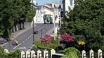 A view of the main road through the village, looking north, August 2022.
 Scoil Treasa Naofa (St.Teresa's National School), townland of Castletown.
 St. Columba's heritage centre, formerly a protestant church erected c.1810-11 on the site of a ruinous former church. A belltower was added in 1840. Restoration was completed in 1993. The graveyard contains protestant and catholic burials.
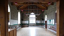 The interior of St. Columba's heritage centre, an active village hall containing accounts of the local history around the walls.
 The Republican plot at St. Columba's, grave of George O'Shea, Timothy Tuomey and Timothy Lyons, the former two of Kilflynn killed in the Ballyseedy massacre, the latter of Garrynagore killed at Clashmealcon caves.
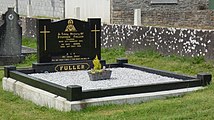 The grave at St. Columba's of Stephen Fuller, sole survivor of the Ballyseedy massacre and later a T.D. for Fianna Fáil.
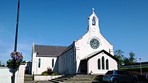 St. Mary's Roman Catholic church. Dated 1849, it was extended in 1935 and renovated in 1979.
 A gate lodge at the northern edge of the old Crotta estate, built c.1850. This is the only extant whole structure of the estate. Crotta House was finally demolished in the 20th century.
 The shrine constructed around Tobar Flainn - the holy well of St.Flainn - by Muintir na Tíre in 1953. The issue was formerly from some stones near the Rae, a tributary by the well that joins the Shannow.
 Panorama made from the road between Kilflynn village and the N69, looking across the Listowel plain from the townland of Glanballyma.
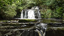 Part of the waterfall of the River Shannow between the townlands of Gortclohy and Glanballyma. The vertical drop of the whole falls is about 20 metres.


,_Kilflynn.jpg)


