| Kilcoolaght East Ogham Stones | |
|---|---|
| Native name Irish: Clocha Oghaim Chill Chuallachta Thoir | |
 The stones with
MacGillycuddy's Reeks in the background | |
| Type | ogham stones |
| Location | Kilcoolaght East,
Killorglin, County Kerry, Ireland |
| Coordinates | 52°04′26″N 9°44′45″W / 52.073956°N 9.745798°W |
| Elevation | 22 m (72 ft) |
| Owner | state |
| Official name | Kilcoolaght East Ogham Stones [1] |
| Reference no. | 329 [2] |
 Location of Kilcoolaght East Ogham Stones in Ireland | |
Kilcoolaght East Ogham Stones (CIIC 206–213) are a collection of ogham stones forming a National Monument located in County Kerry, Ireland. [3]
Location
Kilcoolaght East Ogham Stones are located 4.6 kilometres (2.9 mi) southeast of Killorglin, to the west of the Glasheenasheefree River. [4]
History
The stones were carved in the 5th and 6th centuries AD and served as burial markers. This was a ceallurach (burial ground). [5] [6]
All the stones were found in a souterrain nearby. [7]
Description
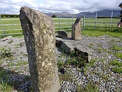
The stones are sandstone pillars. [8]
- CIIC 206: [AN]M VIRR[ACC(?)]/ANNI TIGIR[N] ("name/inscription of Ferchán/Fírchán? of Tigern") and C̣/̣ṬẸDATTOQA MAQI/ VEDELMETṬ[O(?)] ("of Cétadach? son of Fedelmid/Feidlimid")
- CIIC 207: ẸCC MAQI L[UGUQ]ṚRIT ("of Éc? son of Luccreth")
- CIIC 208: UMALL
- CIIC 209: A]GGO MAQI AGỊ[LL ("...ggo son of Agi...")
- CIIC 210: DUBE[B and Q/N
- CIIC 211: [RI]TTẠVV[E]CC MAQ[I] V[E]DDONỌS ("of Rethach son of Feddonos"; this name survives in the Iveragh Peninsula)
- CIIC 212: highly fragmentary
- CIIC 213: URG̣ [9]
Gallery
-
 The enclosure as seen from afar
 -
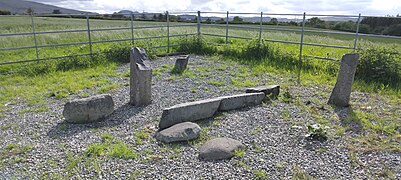 The stones in the enclosure
 -
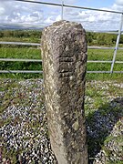 One of the pillars
 -
 One of the pillars
 -
 A collapsed and fragmented pillar
 -
 One of the pillars


See also
References
- ^ "The national monuments of the Irish Free State". Stationery Office. 19 September 2017 – via Google Books.
-
^
"Archived copy" (PDF). Archived from
the original (PDF) on 17 December 2010. Retrieved 19 September 2017.
{{
cite web}}
: CS1 maint: archived copy as title ( link) - ^ O'Sullivan, Ann; Sheehan, John (19 September 1996). The Iveragh peninsula: an archaeological survey of South Kerry. Cork University Press. ISBN 9780902561847 – via Google Books.
- ^ Graham-Campbell, James; Ryan, Michael (19 September 2017). Anglo-Saxon/Irish Relations Before the Vikings. Oxford University Press. ISBN 9780197264508 – via Google Books.
- ^ Weir, Anthony (19 September 1980). Early Ireland: a field guide. Blackstaff Press. ISBN 9780856402128 – via Google Books.
- ^ Evans, Emyr Estyn (19 September 1978). Irish world. ISBN 9780810911208 – via Google Books.
- ^ "Kilcoolaght East Ogham Stones". www.megalithicmonumentsofireland.com.
- ^ "Kilcoolaght East Ogham Stones". irishantiquities.bravehost.com.
- ^ "Ogham in 3D - Kilcoolaght East / 206. Kilcoolaght East I". ogham.celt.dias.ie.
| Kilcoolaght East Ogham Stones | |
|---|---|
| Native name Irish: Clocha Oghaim Chill Chuallachta Thoir | |
|
The stones with
MacGillycuddy's Reeks in the background | |
| Type | ogham stones |
| Location | Kilcoolaght East,
Killorglin, County Kerry, Ireland |
| Coordinates | 52°04′26″N 9°44′45″W / 52.073956°N 9.745798°W |
| Elevation | 22 m (72 ft) |
| Owner | state |
| Official name | Kilcoolaght East Ogham Stones [1] |
| Reference no. | 329 [2] |
Location of Kilcoolaght East Ogham Stones in Ireland | |
Kilcoolaght East Ogham Stones (CIIC 206–213) are a collection of ogham stones forming a National Monument located in County Kerry, Ireland. [3]
Location
Kilcoolaght East Ogham Stones are located 4.6 kilometres (2.9 mi) southeast of Killorglin, to the west of the Glasheenasheefree River. [4]
History
The stones were carved in the 5th and 6th centuries AD and served as burial markers. This was a ceallurach (burial ground). [5] [6]
All the stones were found in a souterrain nearby. [7]
Description
The stones are sandstone pillars. [8]
- CIIC 206: [AN]M VIRR[ACC(?)]/ANNI TIGIR[N] ("name/inscription of Ferchán/Fírchán? of Tigern") and C̣/̣ṬẸDATTOQA MAQI/ VEDELMETṬ[O(?)] ("of Cétadach? son of Fedelmid/Feidlimid")
- CIIC 207: ẸCC MAQI L[UGUQ]ṚRIT ("of Éc? son of Luccreth")
- CIIC 208: UMALL
- CIIC 209: A]GGO MAQI AGỊ[LL ("...ggo son of Agi...")
- CIIC 210: DUBE[B and Q/N
- CIIC 211: [RI]TTẠVV[E]CC MAQ[I] V[E]DDONỌS ("of Rethach son of Feddonos"; this name survives in the Iveragh Peninsula)
- CIIC 212: highly fragmentary
- CIIC 213: URG̣ [9]
Gallery
-
The enclosure as seen from afar
-
The stones in the enclosure
-
One of the pillars
-
One of the pillars
-
A collapsed and fragmented pillar
-
One of the pillars
See also
References
- ^ "The national monuments of the Irish Free State". Stationery Office. 19 September 2017 – via Google Books.
-
^
"Archived copy" (PDF). Archived from
the original (PDF) on 17 December 2010. Retrieved 19 September 2017.
{{
cite web}}
: CS1 maint: archived copy as title ( link) - ^ O'Sullivan, Ann; Sheehan, John (19 September 1996). The Iveragh peninsula: an archaeological survey of South Kerry. Cork University Press. ISBN 9780902561847 – via Google Books.
- ^ Graham-Campbell, James; Ryan, Michael (19 September 2017). Anglo-Saxon/Irish Relations Before the Vikings. Oxford University Press. ISBN 9780197264508 – via Google Books.
- ^ Weir, Anthony (19 September 1980). Early Ireland: a field guide. Blackstaff Press. ISBN 9780856402128 – via Google Books.
- ^ Evans, Emyr Estyn (19 September 1978). Irish world. ISBN 9780810911208 – via Google Books.
- ^ "Kilcoolaght East Ogham Stones". www.megalithicmonumentsofireland.com.
- ^ "Kilcoolaght East Ogham Stones". irishantiquities.bravehost.com.
- ^ "Ogham in 3D - Kilcoolaght East / 206. Kilcoolaght East I". ogham.celt.dias.ie.