Photos • Location

Kidds Crossing, Kentucky | |
|---|---|
 Kidds Crossing  Kidds Crossing | |
| Coordinates: 36°45′23″N 84°40′48″W / 36.75639°N 84.68000°W | |
| Country | United States |
| State | Kentucky |
| County | Wayne |
| Elevation | 896 ft (273 m) |
| Time zone | UTC-5 ( Eastern (EST)) |
| • Summer ( DST) | UTC-4 (EDT) |
| Area code | 606 |
| GNIS feature ID | 508388 [1] |
Kidds Crossing is an unincorporated community in Wayne County, Kentucky, United States. [1] The community is on Kentucky Route 92 near the McCreary County border, 10.7 miles (17.2 km) east-southeast of Monticello. [2]
References
- ^ a b "Kidds Crossing". Geographic Names Information System. United States Geological Survey, United States Department of the Interior.
- ^ State Primary Road System: Wayne County (PDF) (Map). Kentucky Transportation Cabinet. May 2018. Retrieved August 5, 2019.
Municipalities and communities of
Wayne County, Kentucky, United States | ||
|---|---|---|
| City | 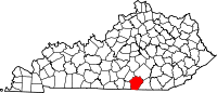 | |
|
Unincorporated communities | ||
| Ghost town | ||
|
| This Wayne County, Kentucky state location article is a stub. You can help Wikipedia by expanding it. |
Kidds Crossing, Kentucky | |
|---|---|
Kidds Crossing Kidds Crossing | |
| Coordinates: 36°45′23″N 84°40′48″W / 36.75639°N 84.68000°W | |
| Country | United States |
| State | Kentucky |
| County | Wayne |
| Elevation | 896 ft (273 m) |
| Time zone | UTC-5 ( Eastern (EST)) |
| • Summer ( DST) | UTC-4 (EDT) |
| Area code | 606 |
| GNIS feature ID | 508388 [1] |
Kidds Crossing is an unincorporated community in Wayne County, Kentucky, United States. [1] The community is on Kentucky Route 92 near the McCreary County border, 10.7 miles (17.2 km) east-southeast of Monticello. [2]
References
- ^ a b "Kidds Crossing". Geographic Names Information System. United States Geological Survey, United States Department of the Interior.
- ^ State Primary Road System: Wayne County (PDF) (Map). Kentucky Transportation Cabinet. May 2018. Retrieved August 5, 2019.
Municipalities and communities of
Wayne County, Kentucky, United States | ||
|---|---|---|
| City | | |
|
Unincorporated communities | ||
| Ghost town | ||
|
| This Wayne County, Kentucky state location article is a stub. You can help Wikipedia by expanding it. |