Khuha Sawan
คูหาสวรรค์ | |
|---|---|

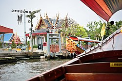
Wat Khuha Sawan, an eponymous | |
 Location in
Phasi Charoen District | |
| Coordinates: 13°44′36.9″N 100°27′34.7″E / 13.743583°N 100.459639°E | |
| Country | |
| Province | Bangkok |
| Khet | Phasi Charoen |
| Area | |
| • Total | 0.909 km2 (0.351 sq mi) |
| Population (2020) | |
| • Total | 6,063 |
| Time zone | UTC+7 ( ICT) |
| Postal code | 10160 |
| TIS 1099 | 102210 |
Khuha Sawan ( Thai: คูหาสวรรค์, pronounced [kʰūː.hǎː sā.wǎn]) is a khwaeng (subdistrict) of Phasi Charoen District, in Bangkok, Thailand. In 2020, it had a total population of 6,063 people. [2]
Denomination
Its name Khuha Sawan (lit: "celestial cavern") after a local temple, Wat Khuha Sawan, a historic Buddhist temple, formerly known as Wat Sala Si Na (วัดศาลาสี่หน้า).
Geography
It is sort of shaped like a boot with toe not far from the Bang Wa BTS Skytrain and Bang Wa MRT Subway stations. It shares a border with sister subdistrict Pak Khlong Phasi Charoen. Both areas are informally known collectively as "Bang Phai".
Khuha Sawan borders Bang Phrom and Khlong Chak Phra to the north ( Khlong Bang Chueak Nang is a borderline), Bang Khun Si and Wat Tha Phra to the east ( Khlong Bang Khun Si, Khlong Mon and Khlong Bangkok Yai are the borderlines), Pak Khlong Phasi Charoen to the south (Khlong Bang Chak is a borderline), Bang Chak and Bang Waek to the west.
It has a total area of 0.909 km2 (0.351 sq mi). Regarded as the smallest administrative area of Phasi Charoen District.
Places
- Khlong Bang Luang Artist House, also referred to as Bann Silapin
- Wat Khuha Sawan
- Wat Paknam Fang Tai
- Wat Wichitkarnnimit (Wat Nang)
- Wat Nok
- Wat Bang Waek
- Wat Bot Ittharasanpetch
- Sutham Suksa School and Wat Suwan Khiri (abandoned)
- Thonburi Commercial College
- Bang Sao Thong Police Station
- Sujinwadee School
References
-
^ Administrative Strategy Division, Strategy and Evaluation Department, Bangkok Metropolitan Administration (2021).
สถิติกรุงเทพมหานครประจำปี 2563 [Bangkok Statistics 2020] (PDF) (in Thai). Retrieved 27 November 2021.
{{
cite web}}
: CS1 maint: multiple names: authors list ( link) - ^ "Population statistics 2020" (in Thai). Department of Provincial Administration. Retrieved 12 October 2021.
Khuha Sawan
คูหาสวรรค์ | |
|---|---|

Wat Khuha Sawan, an eponymous | |
 Location in
Phasi Charoen District | |
| Coordinates: 13°44′36.9″N 100°27′34.7″E / 13.743583°N 100.459639°E | |
| Country | |
| Province | Bangkok |
| Khet | Phasi Charoen |
| Area | |
| • Total | 0.909 km2 (0.351 sq mi) |
| Population (2020) | |
| • Total | 6,063 |
| Time zone | UTC+7 ( ICT) |
| Postal code | 10160 |
| TIS 1099 | 102210 |
Khuha Sawan ( Thai: คูหาสวรรค์, pronounced [kʰūː.hǎː sā.wǎn]) is a khwaeng (subdistrict) of Phasi Charoen District, in Bangkok, Thailand. In 2020, it had a total population of 6,063 people. [2]
Denomination
Its name Khuha Sawan (lit: "celestial cavern") after a local temple, Wat Khuha Sawan, a historic Buddhist temple, formerly known as Wat Sala Si Na (วัดศาลาสี่หน้า).
Geography
It is sort of shaped like a boot with toe not far from the Bang Wa BTS Skytrain and Bang Wa MRT Subway stations. It shares a border with sister subdistrict Pak Khlong Phasi Charoen. Both areas are informally known collectively as "Bang Phai".
Khuha Sawan borders Bang Phrom and Khlong Chak Phra to the north ( Khlong Bang Chueak Nang is a borderline), Bang Khun Si and Wat Tha Phra to the east ( Khlong Bang Khun Si, Khlong Mon and Khlong Bangkok Yai are the borderlines), Pak Khlong Phasi Charoen to the south (Khlong Bang Chak is a borderline), Bang Chak and Bang Waek to the west.
It has a total area of 0.909 km2 (0.351 sq mi). Regarded as the smallest administrative area of Phasi Charoen District.
Places
- Khlong Bang Luang Artist House, also referred to as Bann Silapin
- Wat Khuha Sawan
- Wat Paknam Fang Tai
- Wat Wichitkarnnimit (Wat Nang)
- Wat Nok
- Wat Bang Waek
- Wat Bot Ittharasanpetch
- Sutham Suksa School and Wat Suwan Khiri (abandoned)
- Thonburi Commercial College
- Bang Sao Thong Police Station
- Sujinwadee School
References
-
^ Administrative Strategy Division, Strategy and Evaluation Department, Bangkok Metropolitan Administration (2021).
สถิติกรุงเทพมหานครประจำปี 2563 [Bangkok Statistics 2020] (PDF) (in Thai). Retrieved 27 November 2021.
{{
cite web}}
: CS1 maint: multiple names: authors list ( link) - ^ "Population statistics 2020" (in Thai). Department of Provincial Administration. Retrieved 12 October 2021.