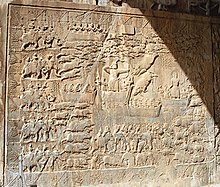
Archeological exploration about khosrow parviz hunting ground in year 2009Inscriptions from Khosrow parviz hunting ground on a stone inscription in
Taq-e Bostan
Khosrow parviz hunting ground (
Persian:شکارگاه خسرو پرویز) or Tape-ye-moradhasel (Persian:تپه مرادحاصل) is an ancient
Sasanid complex in the north of
Kermanshah city in western
Iran.[1]