Khnushinak
Խնուշինակ Xanoba | |
|---|---|
 Scenery around Khnushinak | |
 Khnushinak | |
| Coordinates: 39°45′51.8″N 47°02′25.8″E / 39.764389°N 47.040500°E | |
| Country | |
| • District | Khojavend |
| Population (2015)
[1] | |
| • Total | 615 |
| Time zone | UTC+4 ( AZT) |
Khnushinak ( Armenian: Խնուշինակ) or Khanoba ( Azerbaijani: Xanoba) is a village located in the Khojavend District of Azerbaijan, in the region of Nagorno-Karabakh. The village had an ethnic Armenian population before 2023 and in 1989. [2]
History
During the Soviet period, the village was a part of the Martuni District of the Nagorno-Karabakh Autonomous Oblast.
Historical heritage sites
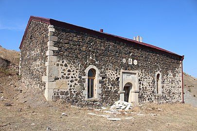
Historical heritage sites in and around the village include the 19th-century church of Surb Astvatsatsin ( Armenian: Սուրբ Աստվածածին, lit. 'Holy Mother of God'), and the 19th/20th-century village of Hin Khnushinak ( Armenian: Հին Խնուշինակ, lit. 'Old Khnushinak') [1]
Economy and culture
The population is mainly engaged in agriculture and animal husbandry. As of 2015, the village has a municipal building, a house of culture, a secondary school, two shops, and a medical centre. [1]
Demographics
The village had 664 inhabitants in 2005, [3] and 615 inhabitants in 2015. [1]
Gallery
-
 St. Astvatsatsin Church
 -
 St. Astvatsatsin Church interior
 -
 A monument for the fallen in the First Nagorno-Karabakh War
 -
 The ruined village of Hin Khnushinak


References
- ^ a b c d Hakob Ghahramanyan. "Directory of socio-economic characteristics of NKR administrative-territorial units (2015)".
- ^ Андрей Зубов. "Андрей Зубов. Карабах: Мир и Война". drugoivzgliad.com.
- ^ "The Results of the 2005 Census of the Nagorno-Karabakh Republic" (PDF). National Statistic Service of the Republic of Artsakh.
External links
Capital:
Martuni | ||
| Urban communities |  | |
| Rural communities | ||
| Not under Artsakh control |
| |

|
| This Khojavend District location article is a stub. You can help Wikipedia by expanding it. |
|
| This Artsakh location article is a stub. You can help Wikipedia by expanding it. |
Khnushinak
Խնուշինակ Xanoba | |
|---|---|
|
Scenery around Khnushinak | |
Khnushinak | |
| Coordinates: 39°45′51.8″N 47°02′25.8″E / 39.764389°N 47.040500°E | |
| Country | |
| • District | Khojavend |
| Population (2015)
[1] | |
| • Total | 615 |
| Time zone | UTC+4 ( AZT) |
Khnushinak ( Armenian: Խնուշինակ) or Khanoba ( Azerbaijani: Xanoba) is a village located in the Khojavend District of Azerbaijan, in the region of Nagorno-Karabakh. The village had an ethnic Armenian population before 2023 and in 1989. [2]
History
During the Soviet period, the village was a part of the Martuni District of the Nagorno-Karabakh Autonomous Oblast.
Historical heritage sites
Historical heritage sites in and around the village include the 19th-century church of Surb Astvatsatsin ( Armenian: Սուրբ Աստվածածին, lit. 'Holy Mother of God'), and the 19th/20th-century village of Hin Khnushinak ( Armenian: Հին Խնուշինակ, lit. 'Old Khnushinak') [1]
Economy and culture
The population is mainly engaged in agriculture and animal husbandry. As of 2015, the village has a municipal building, a house of culture, a secondary school, two shops, and a medical centre. [1]
Demographics
The village had 664 inhabitants in 2005, [3] and 615 inhabitants in 2015. [1]
Gallery
-
St. Astvatsatsin Church
-
St. Astvatsatsin Church interior
-
A monument for the fallen in the First Nagorno-Karabakh War
-
The ruined village of Hin Khnushinak
References
- ^ a b c d Hakob Ghahramanyan. "Directory of socio-economic characteristics of NKR administrative-territorial units (2015)".
- ^ Андрей Зубов. "Андрей Зубов. Карабах: Мир и Война". drugoivzgliad.com.
- ^ "The Results of the 2005 Census of the Nagorno-Karabakh Republic" (PDF). National Statistic Service of the Republic of Artsakh.
External links
Capital:
Martuni | ||
| Urban communities | | |
| Rural communities | ||
| Not under Artsakh control |
| |
|
| This Khojavend District location article is a stub. You can help Wikipedia by expanding it. |
|
| This Artsakh location article is a stub. You can help Wikipedia by expanding it. |