Photos • Location

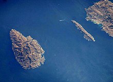
Kea (left) and Makronisos from the
International Space Station

The Kea Channel, is a passage of water in the Aegean Sea. lying between the islands of Kea and Makronisos, just off Cape Sounion, Attica on the mainland of Greece.
The channel is the location of the wreck of HMHS Britannic, sunk on 21 November 1916.

The Kea Channel, is a passage of water in the Aegean Sea. lying between the islands of Kea and Makronisos, just off Cape Sounion, Attica on the mainland of Greece.
The channel is the location of the wreck of HMHS Britannic, sunk on 21 November 1916.