Katsepy | |
|---|---|
 Light House of Katsepy | |
 Katsepy Location in Madagascar | |
| Coordinates: 15°46′S 46°14′E / 15.767°S 46.233°E | |
| Country | |
| Region | Boeny |
| District | Mitsinjo |
| Elevation | 25 m (82 ft) |
| Population (2001)
[2] | |
| • Total | 10,000 |
| Time zone | UTC3 ( EAT) |
| Postal code | 417 |
Katsepy is a municipality in Madagascar. It belongs to the district of Mitsinjo, which is a part of Boeny Region. The population of the commune was estimated to be approximately 10,000 in 2001 commune census. [2]

Katsepy has a maritime harbour. It is situated on the opposite side of the Betsiboka River from Mahajanga from where the town can be reached by a ferry. Only primary schooling is available. Farming and raising livestock provides employment for 40% and 30% of the working population. The most important crop is rice, while other important products are seeds of catechu and raffia palm. Services provide employment for 1% of the population. Additionally fishing employs 29% of the population. [2]
Before 2006, a project for building an ethanol plant was started. During two years, all studies are realized. However, the unsettled political climate in Madagascar put an end to this project. [3]
Infrastructures
Katsepy has a small riverine harbour for the ferry across the Bombetoka Bay to Mahajanga. It is also the startpoint of the unpaved National road 19 to Soalala and Maintirano.
-
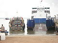 The ferry to Mahajanga
 -
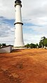 The lighthouse
 -
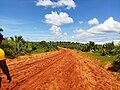 National road 19 T


Light House
In Katsepy is found a light house that was constructed in 1901. [4]
- ^ Estimated based on DEM data from Shuttle Radar Topography Mission
- ^ a b c "ILO census data". Cornell University. 2002. Retrieved 2008-03-03.
- ^ Madagascar Ethanol programm
- ^ Sea Seek: Phare de Katsepy
Capital:
Mahajanga | ||
| Ambato-Boeni (11) (403) |  | |
| Mahajanga (1) | ||
| Mahajanga II (9) (402) | ||
| Marovoay (12) (416) | ||
| Mitsinjo (7) (417) | ||
| Soalala (3) (420) | ||
6 districts; 43 communes | ||
Katsepy | |
|---|---|
|
Light House of Katsepy | |
Katsepy Location in Madagascar | |
| Coordinates: 15°46′S 46°14′E / 15.767°S 46.233°E | |
| Country | |
| Region | Boeny |
| District | Mitsinjo |
| Elevation | 25 m (82 ft) |
| Population (2001)
[2] | |
| • Total | 10,000 |
| Time zone | UTC3 ( EAT) |
| Postal code | 417 |
Katsepy is a municipality in Madagascar. It belongs to the district of Mitsinjo, which is a part of Boeny Region. The population of the commune was estimated to be approximately 10,000 in 2001 commune census. [2]
Katsepy has a maritime harbour. It is situated on the opposite side of the Betsiboka River from Mahajanga from where the town can be reached by a ferry. Only primary schooling is available. Farming and raising livestock provides employment for 40% and 30% of the working population. The most important crop is rice, while other important products are seeds of catechu and raffia palm. Services provide employment for 1% of the population. Additionally fishing employs 29% of the population. [2]
Before 2006, a project for building an ethanol plant was started. During two years, all studies are realized. However, the unsettled political climate in Madagascar put an end to this project. [3]
Infrastructures
Katsepy has a small riverine harbour for the ferry across the Bombetoka Bay to Mahajanga. It is also the startpoint of the unpaved National road 19 to Soalala and Maintirano.
-
The ferry to Mahajanga
-
The lighthouse
-
National road 19 T
Light House
In Katsepy is found a light house that was constructed in 1901. [4]
- ^ Estimated based on DEM data from Shuttle Radar Topography Mission
- ^ a b c "ILO census data". Cornell University. 2002. Retrieved 2008-03-03.
- ^ Madagascar Ethanol programm
- ^ Sea Seek: Phare de Katsepy
Capital:
Mahajanga | ||
| Ambato-Boeni (11) (403) | | |
| Mahajanga (1) | ||
| Mahajanga II (9) (402) | ||
| Marovoay (12) (416) | ||
| Mitsinjo (7) (417) | ||
| Soalala (3) (420) | ||
6 districts; 43 communes | ||