Photos • Location
You can help expand this article with text translated from
the corresponding article in Japanese. (August 2011) Click [show] for important translation instructions.
|
| Kassa Dam | |
|---|---|
 | |
| Official name | カッサダム |
| Location | Yuzawa, Niigata, Japan |
| Purpose | Power |
| Construction began | 1972 |
| Opening date | 1978 |
| Dam and spillways | |
| Type of dam | Earth fill dam |
| Impounds | Shinano River |
| Height (foundation) | 90 m (295.3 ft) |
| Reservoir | |
| Catchment area | 4.5 km² (1.74 mi²) |
| Okukiyotsu Power Plant Okukiyotsu No. 2 Power Plant | |
| Operator(s) | J-Power |
| Installed capacity | 1,000
MW 600 MW |
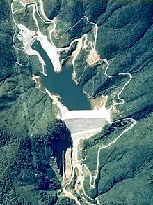
Kassa Dam (カッサダム, Kassa damu) is a dam in Yuzawa, Niigata Prefecture, Japan, completed in 1978. [1]
References
- ^ "Kassa Dam [Niigata Pref.]". damnet.or.jp. Retrieved 2 November 2019.
36°51′30″N 138°44′24″E / 36.85833°N 138.74000°E
You can help expand this article with text translated from
the corresponding article in Japanese. (August 2011) Click [show] for important translation instructions.
|
| Kassa Dam | |
|---|---|
 | |
| Official name | カッサダム |
| Location | Yuzawa, Niigata, Japan |
| Purpose | Power |
| Construction began | 1972 |
| Opening date | 1978 |
| Dam and spillways | |
| Type of dam | Earth fill dam |
| Impounds | Shinano River |
| Height (foundation) | 90 m (295.3 ft) |
| Reservoir | |
| Catchment area | 4.5 km² (1.74 mi²) |
| Okukiyotsu Power Plant Okukiyotsu No. 2 Power Plant | |
| Operator(s) | J-Power |
| Installed capacity | 1,000
MW 600 MW |
Kassa Dam (カッサダム, Kassa damu) is a dam in Yuzawa, Niigata Prefecture, Japan, completed in 1978. [1]
References
- ^ "Kassa Dam [Niigata Pref.]". damnet.or.jp. Retrieved 2 November 2019.
36°51′30″N 138°44′24″E / 36.85833°N 138.74000°E