This article needs additional citations for
verification. (February 2024) |

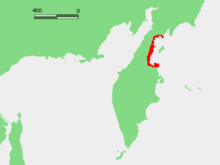
Karaginsky Gulf ( Russian: Карагинский залив) is a large gulf in the Bering Sea off the northeastern coast of Kamchatka ( Russia), which cuts 117 km (73 mi) deep inland. The depth of the gulf is between 30 and 60 m (98 and 197 ft). The largest island in the gulf is the Karaginsky Island, separated from the mainland by the Litke Strait (width: 21 to 72 km (13 to 45 mi)). [1] The Karaginsky Gulf is covered with ice from December until June.
External links
References
- ^ National Marine Fisheries Service. Marine Fisheries Review, Volume 67. NMFS, Scientific Publications Office, 2005. 13.
59°26′00″N 164°00′00″E / 59.43333°N 164.00000°E
This article needs additional citations for
verification. (February 2024) |

Karaginsky Gulf ( Russian: Карагинский залив) is a large gulf in the Bering Sea off the northeastern coast of Kamchatka ( Russia), which cuts 117 km (73 mi) deep inland. The depth of the gulf is between 30 and 60 m (98 and 197 ft). The largest island in the gulf is the Karaginsky Island, separated from the mainland by the Litke Strait (width: 21 to 72 km (13 to 45 mi)). [1] The Karaginsky Gulf is covered with ice from December until June.
External links
References
- ^ National Marine Fisheries Service. Marine Fisheries Review, Volume 67. NMFS, Scientific Publications Office, 2005. 13.
59°26′00″N 164°00′00″E / 59.43333°N 164.00000°E